Location
See also...
Keywords
Authorizations, license
-
Visible by: Everyone -
All rights reserved
-
765 visits
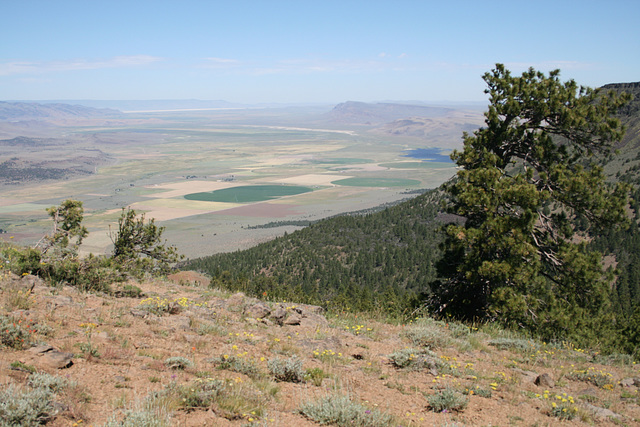
From the Abert Rim--


Looking northwest from a point, accessible to vehicles, that evidently is a popular hang-gliding takeoff spot. The Abert Rim is a large fault scarp, related to Basin and Range crustal extension, that extends some 30 miles (50 km) roughly north-south in south-central Oregon, and stands roughly 2500 ft (~760 m) above the valley floor below. We're near the southern end here. US highway 395 runs more or less horizontally across the valley below, and a cluster of trees marks Valley Falls (note), where Oregon State Route 31 takes off to run northwesterly. Summer Lake (or rather, the playa on the east side thereof) is barely visible in the far distance (note), below Winter Ridge, another fault scarp.
The Chewaucan River flows out of the mountains (Gearhart Mtns) to the left and crosses diagonally in the middle distance, eventually ending in saline Abert Lake (hidden behind the near scarp to the right). The body of water at center-right is a reservoir that stores water from the Chewaucan before it enters the lake. The inset on the right is a close up of this reservoir.
"Abert" (AY-bert) looks like a misspelling of "Albert," but the name comes from John James Abert and his son James William Abert. Both were members of the Corps of Topographical Engineers, which carried out explorations in the West before the US Civil War. The younger Abert was a member of John C. Fremont's expedition which came thru this area in 1843.
tiabunna, Peggy C, Smiley Derleth and 2 other people have particularly liked this photo
- Keyboard shortcuts:
Jump to top
RSS feed- Latest comments - Subscribe to the comment feeds of this photo
- ipernity © 2007-2024
- Help & Contact
|
Club news
|
About ipernity
|
History |
ipernity Club & Prices |
Guide of good conduct
Donate | Group guidelines | Privacy policy | Terms of use | Statutes | In memoria -
Facebook
Twitter

Admired in ~ I ❤ Nature
Seen in: Virtual EXPLORE
www.ipernity.com/group/virtualexplore
slgwv club has replied to Don Barrett (aka DBs… clubslgwv club has replied to tiabunna clubSign-in to write a comment.