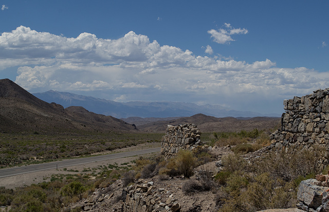
Palmetto, NV (0064)
Palmetto, NV (0062)
Palmetto, NV (0070)
Fish Lake Valley, NV (0071)
Fish Lake Valley (Dyer), NV (0074)
Fish Lake Valley (Dyer), NV (0076)
Fish Lake Valley (Dyer), NV (0077)
Fish Lake Valley (Dyer), NV (0078)
Fish Lake Valley (Dyer), NV (0079)
Fish Lake Valley (Dyer), NV (0080)
Fish Lake Valley, NV (0081)
Fish Lake Valley, NV (0082)
Bear (0514)
Scout (517)
Scout (518)
US- 6 / NV-264 (0084)
US- 6 / NV-264 (0085)
US- 6 / NV-264 (0086)
Montgomery Pass casinos, NV (0087)
Montgomery Pass casinos, NV (0088)
Montgomery Pass casinos, NV (0090)
Montgomery Pass casinos, NV (0091)
Montgomery Pass casinos, NV (0092)
Palmetto, NV (0055)
Palmetto, NV (0056)
Gold Point, NV (0054)
Gold Point, NV (0051)
Gold Point, NV (0050)
Gold Point, NV (0047)
Gold Point, NV (0046)
Gold Point, NV (0045)
Gold Point, NV (0044)
Lida Junction, NV Cottontail brothel (0043)
Lida Junction, NV airport (0042)
Lida Junction, NV Cottontail brothel (0041)
Lida Junction, NV Cottontail brothel (0040)
Lida Junction, NV Cottontail brothel (0038)
Shoshone, CA (0036)
Shoshone, CA (0035)
Shoshone, CA (0033)
Tecopa Hot Springs, CA (0029)
Tecopa Hot Springs, CA (0027)
Tecopa Hot Springs, CA (0026)
Tecopa Hot Springs, CA (0023)
Tecopa Hot Springs, CA (0019)
Location
See also...
Keywords
Authorizations, license
-
Visible by: Everyone -
Attribution + non Commercial + no derivative
-
268 visits
Palmetto, NV (0059)


Among the ruins of the stamping mill in Palmetto. The mountains in the distance are the White Mountains in California.
slgwv, Don Sutherland have particularly liked this photo
- Keyboard shortcuts:
Jump to top
RSS feed- Latest comments - Subscribe to the comment feeds of this photo
- ipernity © 2007-2024
- Help & Contact
|
Club news
|
About ipernity
|
History |
ipernity Club & Prices |
Guide of good conduct
Donate | Group guidelines | Privacy policy | Terms of use | Statutes | In memoria -
Facebook
Twitter

Here's a pic from near the top of the Palmettos (complete with my shadow and the car's--it's not one of my better efforts!) looking west. SR 266 is in the valley to the left, and the Whites are on the skyline to the right, with the high point White Mtn Peak. The Sierra crest is barely visible on the skyline to the left:
www.ipernity.com/doc/289859/22527595/in/album/431575
Don Barrett (aka DBs… club has replied to slgwv clubI've never quite understood how mountain ranges are named. I thought Sierra was a name for the broader range of mountains along the Calif/Nev border and that there were subdivisions within that. I changed the name on this one.
slgwv club has replied to Don Barrett (aka DBs… clubOne of these days we'd like to get back to the Bristlecone Grove. We were just passing thru on the way to the trailhead and didn't have time to linger. Twice a year the UC opens the Barcroft Station to the public, which saves 2 miles or so and ~1000 ft on the summit hike!
Don Barrett (aka DBs… club has replied to slgwv clubI'm relatively famous for being a little loose on some types of details, mainly because I lean towards the words the populous use unless I feel it necessary to make the distinction. (e.g., sometimes SF is the whole bay area, sometimes just the city/county). I think its the case for most Californians that there are really just two names they use for the mountains running along the west and east boundaries of the state -- the Sierras and the Coastal. (You made me just look, Mt. San Jacinto is outside my front door and I thought it was part of the Santa Rosa's, but just found I was wrong! )
Sign-in to write a comment.