Tulare County, CA orange groves (0397)
Tulare County, CA orange groves (0398)
Tulare County, CA orange groves (0401)
Tulare County, CA orange groves (0402)
Cutler, CA citrus (0403)
Cutler, CA citrus (0405)
Orosi, CA (0406)
Orosi, CA (0409)
Modesto, CA Lion Bridge (0411)
Modesto, CA Lion Bridge (0413)
Modesto, CA Lion Bridge (0414)
Modesto, CA Lion Bridge (0415)
Modesto, CA Lion Bridge (0417)
Modesto, CA Lion Bridge (0418)
Modesto, CA Lion Bridge (0420)
Modesto, CA railroad bridge (0419)
Modesto, CA SP depot (0422)
Modesto, CA SP depot (0424)
Los Banos padres bath (0501)
Dos Palos, CA Farmers Rice Co-op (0502)
Dos Palos, CA Farmers Rice Co-op (0503)
Firebaugh, CA signs (0504)
San Joaquin, CA railroad (0505)
San Joaquin, CA railroad (0506)
San Joaquin, CA railroad (0507)
Raisin City, CA (0508)
Raisin City, CA (0509)
Raisin City, CA (0510)
Caruthers, CA District Fair grounds (0511)
Hickman CA canal (1151)
Hickman CA canal egret (1154)
Hickman CA canal egret (1153)
Hickman CA canal no swimming (1150)
Denair CA WPA (1155)
Denair CA WPA (1156)
Denair CA WPA (1159)
Denair CA Amtrak (1161)
Denair CA Amtrak (1163)
Corcoran CA Amtrak (1171)
Fresno Buddhist temple (1165)
Fresno Buddhist temple (1169)
Amtrak San Joaquin NB (1223)
Amtrak San Joaquin (1490)
Amtrak San Joaquin (1491)
Delano CA Sierra theater (#0002)
Atwater CA Castle Air Museum B-52D(#0020)
Atwater CA Castle Air Museum B-52D(#0024)
Atwater CA Castle Air Museum RB-36H (#0032)
Atwater CA Castle Air Museum RB-36H (#0031)
Atwater CA Castle Air Museum B-29A (#0046)
Knights Landing CA (#0066)
Knights Landing CA bridge (#0068)
Meridian CA bridge (#0069)
Colusa CA forgotten Ide memorial (#0071)
Colusa CA forgotten Ide memorial (#0072)
Colusa CA forgotten Ide memorial (#0073)
Atwater CA Castle Air Museum B-24M (#0004)
Atwater CA Castle Air Museum B-24M (#0005)
Atwater CA Castle Air Museum FB-111A (#0039)
Atwater CA Castle Air Museum FB-111A (#0040)
Atwater CA Castle Air Museum C-47 (#0044)
Atwater CA Castle Air Museum B-25J (#0047)
Atwater CA Castle Air Museum B-17G (#0051)
Kern almond solar (1739)
CA -33 Romero Rd bridge (1738)
CA -33 Romero Rd bridge (1737)
CA -33 Romero Rd bridge (1734)
Gustine (1733)
Gustine (1732)
Newman California Northern Railroad (1729)
Newman California Northern Railroad (1728)
Newman California Northern Railroad (1726)
Newman John Sharp monument (1725)
Newman John Sharp monument (1724)
Newman John Sharp monument (1723)
Newman (1721)
Newman theater (1720)
Avenal, CA solar (1551)
Pyramid Hills oil (1546)
Pyramid Hills oil (1549)
Pyramid Hills oil (1544)
Kern Westside oil (1542)
Kern Westside oil CleanHarbors (1541)
Kern Westside oil CleanHarbors (1540)
Buttonwillow, CA jail (1539)
Buttonwillow, CA jail (1538)
Buttonwillow, CA San Joaquin Power (1536)
Buttonwillow, CA railroad siding (1533)
Buttonwillow, CA farm housing (1532)
Kern Westside orchard (1550)
CA -99 old route (1530)
Arvin, CA boots...(1529)
Arvin, CA Primera Iglesia Bautista church (1528)
Arvin, CA Primera Iglesia Bautista (1526)
Kern County CA-243 (1525)
Kern County CA-243 (1523)
Bakersfield National Cemetery (1521)
Bakersfield National Cemetery (1520)
Bakersfield National Cemetery (1519)
Patterson Las Palmas (0588)
Patterson Las Palmas (0587)
Sanger Hotel and Mirror Room (0598)
Sanger, CA Nash (0600)
Del Rey, CA town center (0602)
Del Rey, CA school (0601)
Tuttle, CA Wilson substation (0590)
Tuttle, CA Fancher monument (0592)
Tuttle, CA Fancher monument (0594)
Reedley, CA WCTU fountain and band shell (0604)
Reedley, CA downtown (0606)
Reedley, CA downtown (0607)
Reedley, CA downtown (0609)
Orosi temple / mosque? (0610)
Bitterwater Valley (3513)
Bitterwater Valley (3507)
Bitterwater Valley (3510)
Walnut Grove Bridge, Sacramento Delta
Bakersfield UP station (3425)
Bakersfield UP station (3423)
Tranquility CA (2229)
Taft welcome sign (0687b)
Taft welcome sign (0687)
Taft CA 1121
Taft CA 1120
Shaffer Bridge 0410a
Location
See also...
Keywords
Authorizations, license
-
Visible by: Everyone -
Attribution + non Commercial + no derivative
-
219 visits
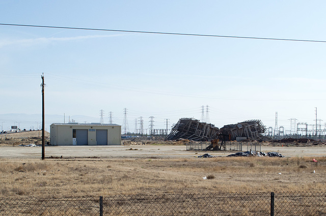
Bakersfield energy history (1741)


Energy history in Bakersfield. The collapsed structure to the right of the center of the picture is a generating facility that is being demolished, barely visible in front of it (in the center of the collapsed building) is an oil well -- all surrounded by towers for the electricity grid.
Christina Sonnenschein, have particularly liked this photo
- Keyboard shortcuts:
Jump to top
RSS feed- Latest comments - Subscribe to the comment feeds of this photo
- ipernity © 2007-2024
- Help & Contact
|
Club news
|
About ipernity
|
History |
ipernity Club & Prices |
Guide of good conduct
Donate | Group guidelines | Privacy policy | Terms of use | Statutes | In memoria -
Facebook
Twitter

Don Barrett (aka DBs… club has replied to ClintSign-in to write a comment.