Gudrun's photos
Cementerio de Trenes
| |
|
|
|
In the late 19th century Uyuni used to be a train hub with railway lines to ports on the pacific coast, mostly for freight trains carrying minerals. Construction was planned and supervised by British engineers invited by the Antofagasta and Bolivia Railway companies. In the 1940s the lines fell into disuse and after the valuable copper parts were removed the locomotives were left to rust.
Laguna Verde - view full size!
| |
|
|
|
Laguna Verde is situated at 4300m in Eduardo Avaroa National Reserve, SW Bolivia, just north of the border with Chile. Its green colour comes from mineral suspensions, among them arsenic. Flamingoes are never seen there, only in neighbouring Laguna Blanca. Because of its high mineral content Laguna Verde never freezes over, even in temperatures as low as -56°C.
EXIF: 1/160 • f/10.0 • 18.0 mm • ISO 100/ Canon EOS 350D/ 18.0-200.0 mm
Laguna Blanca
Laguna Verde
Licancábur y Laguna Verde
Laguna Miscanti - view full size!
| |
|
|
|
EXIF: 1/250 • f/9.0 • 47.0 mm • ISO 100/ Canon EOS 350D/ 18.0-200.0 mm
stitched from 21 verticals
Laguna Miscanti lies at 4140m in the Chilean Altiplano and is part of Reserva Nacional Los Flamencos . It is a brackish lake (fed only by rain and groundwater) that was separated from neighbouring Laguna Miñiques by a lava flow.
See notes and insets!
Volcanes Chiliques y Miscanti
Volcán Miñiques
Salar de Surire- view full size!
| |
|
|
|
Salar de Surire is situated at 4245m near the border to Bolivia. It is part of UNESCO's Lauca Biosphere Reserve and a Ramsar Wetland .
Nevertheless it is only listed as a Monumento Natural (the lowest level of protection) by the Chilean authorities because of Lithium mining.
EXIF: 1/160 • f/9.0 • 31.0 mm • ISO 100/ Canon EOS 350D/ 18.0-200.0 mm
stitched from 21 verticals
Sh*t happens
| |
|
|
|
Accident at the foot of Bolivia's highest mountain, Nevado Sajama (6542m).
Since Bolivia lost the province of Antofagasta and its access to the sea in the late 19th century Guerra del Pacífico, most freight goes from La Paz along Ruta 4 to the border at Tambo Quemado/ Chungará and down to the Chilean port of Arica.
Bolivia still has a Navy (on Lake Titicaca) and annually celebrates Día del Mar. Negotiations with Chile about a corridor the the sea drag along but have never come to a result.
Refuelling
| |
|
|
|
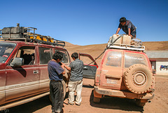
In thinly populated SW Bolivia filling stations are very rare. Cars need to carry their petrol on the roof, refuelling is done as seen in the photo. After 3 days of bumpy tracks one of the canisters started leaking and needed to be emptied.
Washing day
| |
|
|
|
A newly built salt storehouse (still lacking the stairs to the door) and a veteran truck used for drying laundry. See inset photos!
Laguna Capina
| |
|
|
|
Laguna Capina is situated at appr. 4.440m, some 30 km north of Laguna Colorada. It is mined for Borax by manual labour using pick and shovel and a simple workshop and workers' lodgings are on the shore (see inset). The "road" on the left is used by lorries.
EXIF: 1/160 • f/10.0 • 36.0 mm • ISO 100/ Canon EOS 350D/ 18.0-200.0 mm
Laguna Colorada (view on black!)
| |
|
|
|
Laguna Colorada lies at 4278m in Eduardo Avaroa National Reserve in the south western corner of Bolivia. Its red colour stems from halobacteria and algae (dunaliella salina) and a very high copper content.
Laguna Colorada is the breeding ground of several flamingo species, mainly the threatened James's flamingo. In 1990 it was designated a RAMSAR site.
EXIF: 1/100 • f/9.0 • 57.0 mm • ISO 100/ Canon EOS 350D/ 18.0-200.0 mm
Cordillera des los Andes (view on black!)
| |
|
|
|
Andean chain at sunset sen from Valle de la Luna (notes for details!).
All the mountains are volcanic and well above 5000 to over 6000m high. Láscar is one of the most active volcanoes in Chile, its last eruption was in 2013.
Chajnantor plateau (around 5000m) houses the radiotelescopes of ALMA (Atacama Large Millimeter Array) ALMA Opens Its Eyes
EXIF: 1/80 • f/5.6 • 42.0 mm • ISO 100/ Canon EOS 350D/ 18.0-200.0 mm
Sky on fire
| |
|
|
|
Stormclouds over Salar de Uyuni turning colourful at sunset
See inset photo www.ipernity.com/doc/523247/28834717
Salar de Uyuni
| |
|
|
|
The world's largest salt flat covers 10.582 km², is 3656m above sea level and contains approximately 50-70% of the world's lithium reserves in the brine under the salt crust.
en.wikipedia.org/wiki/Salar_de_Uyuni
Clickable note
After the storm
| |
|
|
|
Salar de Uyuni at the end of the dry season. In "Bolivian winter" (actually summer!) the Salar is covered by water which makes it dangerous to drive on.
en.wikipedia.org/wiki/Salar_de_Uyuni
Look up
| |
|
|
|
A rather nondescript office building opposite Afrikahaus
www.youtube.com/watch?v=hJfkyMCOsl4
Cinnamon Tower
| |
|
|
|
57m high apartment building with luxury flats in Hamburg's new HafenCity
dahlercompany.com/de/immobilien/neubauprojekte/cinnamon-tower
Stellahaus
| |
|
|
|
Stellahaus is a typical Hamburg Kontorhaus, built in 1874/75 (arch. Martin Haller). In 1922/23 the top five floors were added (arch. Albert Lindhorst, Edwin Reith und Zaulek & Hartmann)
de.wikipedia.org/wiki/Stellahaus
St. Michaelis
Vitter Kapelle
| |
|
|
|
The octogonal chapel ( designed by Karl Friedrich Schinkel) was built in 1806-16 for the fishermen of Vitt by pastor and writer Ludwig Gotthard Kosegarten.
10-Week Picture Projects: Shapes, Week 9: Diamond


