

Schiff von rechts! :-)
Hamburg, Westfield.
Alle winden sich um die Ankerwinde.
Im Laderaum der Peking.
Auf der Bussalp.
Am Alsterfleet.
Verstrickt.
Jazz Off The Wall, Ascona.
Biblioteca Popolare Ascona.
Neulich abends in Brissago.
Auf Augenhöhe mit den Alpengipfeln.
Kann ich das zurückgeben? Ich habs gelesen. ;-)
Endlich werden auch sie gewürdigt! ;-)
Heidiho was here! :-))
Der Rosenlaui-Gletscher
Gletscherschlucht Rosenlaui.
Gletscherschlucht Rosenlaui
Gletscherschlucht Rosenlaui.
Gletscherschlucht Rosenlaui.
Zugang erschwert !
Antelope Canyon, Arizona.
Blick vom Säntis auf den Altmann, 2'436 m.
Blick vom Säntis.
Neulich abends in Brissago.
25 May: Towel Day
Denkmal nach ...
Landungsbrücken und Hafen.
Landungsbrücken und Hafen.
Blau gegen Blau.
Einer der vier Masten der Peking.
Die Hamburgische Dreifaltigkeit.
Oevelgönne in der Abendsönne.
Die Elphi zur Blauen Stunde.
Hamburg - U-Bahn Station "Überseequartier"
"Fäkalien Abgang"
Neulich an der Marktstrasse in Hamburg.
Aufgestockt
Am Grünen Bunker, Hamburg
Sand aus Hamburg
Am Bremer Kai, im Hafenmuseum Hamburg.
Splash !
U-Bahn Station "Überseequartier" - Hamburg
Seemannsgarn der gröberen Art.
"Junge komm bald wieder."
Neulich im Hamburger Hafen.
1/5072 • f/1.7 • 4.2 mm • ISO 40 •
samsung SM-G950F
Location
Lat, Lng:
You can copy the above to your favourite mapping app.
Address: unknown
You can copy the above to your favourite mapping app.
Address: unknown
See also...
Keywords
Authorizations, license
-
Visible by: Everyone -
All rights reserved
-
883 visits
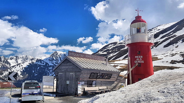
Recently on the Oberalp Pass (2'044 m)

Happy Bench Monday !
The highest lighthouse in Europe on the Oberalp Pass.
The lighthouse on the Oberalp Pass (2'044 m / 6,700 ft) is located near the source of the Rhine. The tower was built as a symbol of the connection between the beginning and end of the Rhine. The tower is a copy of a real lighthouse that once stood at the mouth of the Rhine in Rotterdam.
It is the highest lighthouse in Europe. And after the lighthouse in Puno on Lake Titicaca on the border between Peru and Bolivia (3'800 m above sea level), it is even the second highest lighthouse in the world! :-)
Water - the element of life.
The four rivers Rhine, Reuss, Ticino and Rhone rise in the Gotthard massif in Switzerland and ultimately flow into three different seas:
- The Rhine flows into the North Sea.
- The Reuss flows into the Aare -> Rhine -> North Sea.
- The Ticino flows into the Po -> Adriatic Sea.
- The Rhone flows into the Mediterranean.
The 90-kilometre "Four Springs Trail" leads to the sources of these four rivers and can be covered in one-day stages or in a continuous five-day hike. The trail allows you to discover unique landscapes and raises awareness of the importance of water as a valuable resource.
The "Four Springs Trail Foundation" was set up to realize and manage the trail.
► Swiss Map
► Leuchtturm Rheinquelle (German)
(46.65876, 08.67109); [180°]
SV1XV, Boarischa Krautmo, WiePet, niraK68 and 17 other people have particularly liked this photo
- Keyboard shortcuts:
Jump to top
RSS feed- Latest comments - Subscribe to the comment feeds of this photo
- ipernity © 2007-2026
- Help & Contact
|
Club news
|
About ipernity
|
History |
ipernity Club & Prices |
Guide of good conduct
Donate | Group guidelines | Privacy policy | Terms of use | Statutes | In memoria -
Facebook
X

hBM
polytropos club has replied to Jaap van 't Veen clubpolytropos club has replied to Gudrun clubpolytropos club has replied to Annemarie clubpolytropos club has replied to Trudy Tuinstra clubpolytropos club has replied to Wierd Folkersma clubpolytropos club has replied to Percy Schramm clubpolytropos club has replied to Roger (Grisly) clubpolytropos club has replied to Xata clubXata club has replied to polytropos clubpolytropos club has replied to Xata clubHBM and have a good week ahead
Pam J would love these lighthouse shots
polytropos club has replied to Ecobird clubI put it in the group "Pictures for Pam".
polytropos club has replied to Ko Hummel clubHBM und einen guten Start in die Woche, Poly!
polytropos club has replied to trester88 clubEine gute Woche dir!
polytropos club has replied to Pam J clubThanks a lot for your visit!
HBM en retard et agréable journée paisible et salutaire.
polytropos club has replied to Malik Raoulda clubBonne semaine à toi!
polytropos club has replied to Marije Aguillo clubpolytropos club has replied to tiabunna clubpolytropos club has replied to Franck Chabal clubpolytropos club has replied to Boarischa Krautmo clubSign-in to write a comment.