

Roger (Grisly)'s photos


Quayside Market
Another image looking across the marina from the East Quay this time to the colourful market stalls on the Southern quayside at Watchet on the Somerset Coast!
The long retired lifeboat in center of the image is possibly an ex RNLI Liverpool class boat from around 1939,
although this is not conclusive, any information would be welcome!
HWW! To all,,,,,,,,,,,,,, Large for detail!

Marina View.
Watchet Marina is a sheltered 150-berth marina located within the historic Watchet Harbour on the Somerset coast in the Bristol Channel, UK. It offers a safe haven for boats with good access for cruising along the South West England and Welsh coastlines.
The surrounding town of Watchet is a charming coastal spot with quaint houses, shops, pubs, cafés, and restaurants. Nearby attractions include the West Somerset Steam Railway (which runs alongside the marina),
HBM and a good week, planters still awaiting flowers, Wind blowing off of the channel still a little chilly.

Lady & Dog.
Contest without prize, Bridgwater Bay

From the Top, 3 Notes.
From the top of the Falkirk Wheel with the Ochil Hills as a backdrop!
The wheel resembles a giant double-headed axe or Celtic-inspired structure and rotates like a seesaw. Here's the clever mechanism:Two large gondolas (caissons) sit opposite each other on the wheel's arms, each filled with water and capable of holding boats.
Boats enter a gondola at the bottom (Forth & Clyde level) or top (via an aqueduct leading to the Union Canal).
As the wheel rotates 180 degrees (taking about 5 minutes for a full cycle), one gondola rises while the other descends.
The system stays perfectly balanced thanks to Archimedes' principle: A boat displaces its own weight in water, so the gondolas remain equal in weight regardless of the vessels inside.
Sophisticated gears (including a fixed "sun" gear and rotating "planet" gears) keep the gondolas level at all times, preventing the water and boats from tipping out.
Power required is minimal — roughly 1.5 kWh per rotation, equivalent to boiling about 8 kettles — thanks to hydraulic motors overcoming mainly friction.
HFF and a good weekend to all, A large view for detail please!
A short time lapse video available here. www.youtube.com/watch?v=ucg1O-5jsnM

Bascule Bridge.
Dunbar Harbour is a historic and scenic working harbour located in the coastal town of Dunbar, East Lothian, Scotland, on the southern shores of the Firth of Forth and the North Sea. It's about 30 miles (48 km) east of Edinburgh and 30 miles north of Berwick-upon-Tweed
It's a working fishing port that primarily lands shellfish, with a fleet of commercial boats alongside leisure craft, sailing club vessels, kayaks, paddleboards, rowers, and divers,
HWW !.........From the archives and in 16.9 format therefor a large view may be good

No Name & Blue
This is the Forth and Clyde Canal. In 1963 the canal was closed rather than construct a motorway crossing, and so it became disused and semi-derelict. Canal locks in the Falkirk area on the Union Canal near the connection to the Forth and Clyde canal had been filled in and built over in the 1930s.
As part of the millennium celebrations in 2000, National Lottery funds were used to regenerate both canals. A boatlifting device, the Falkirk Wheel, was built to connect the two canals and once more allow boats to travel from the Clyde or Glasgow to Edinburgh, with a new canal connection to the River Carron and hence the River Forth. The Falkirk Wheel opened on 27 May 2002 and is now a tourist attraction.
HBM and a good week to all, ,,,,,, in 16.9 format therefore a large view may be better!

Lighthouse with Fence
A misty view of the Loch Indaal Lighthouse, Port Charlotte, Island of Islay.
Discovered in the archives and taken on the first of many visits to The Whisky Island,
The lighthouse (also known as Rubh'an Duin or Rubha an Duin) is a picturesque, compact lighthouse on the southeast side of the Rhinns of Islay peninsula, on the island of Islay (one of Scotland's Inner Hebrides, often called the "Queen of the Hebrides" or "whisky island"). It sits near the village of Port Charlotte, overlooking the sea loch of the same name.
Built: 1869 by renowned Scottish lighthouse engineers David and Thomas Stevenson, About 13 metres (43 ft) — a relatively short, "stumpy" white cylindrical brick tower with a balcony, lantern room, black dome, and ochre/yellow trim
HFF and a good weekend ,,,,,,,, in 16.9 format therefore a large view may be good!

Religious Ruin
A somber sky and mood for this image of Bornesketaig Church, which is a ruined church on the Trotternish Peninsula of the Isle of Skye, Scotland.
It sits in the Kilmuir area, visible from Kilmuir Cemetery. The ruins stand on a grassy slope above Camus Mor Bay, overlooking the sea—making it a handy navigational landmark for vessels in the past,
Built in 1810.
Still shown as intact on Ordnance Survey maps from 1903.
Recorded as a ruin by the 1961 map (it likely fell into disuse sometime in between, possibly around the 1920s when a new church opened nearby in Balgown).
HWW to all!,,,,,,,,,,, Large perhaps !
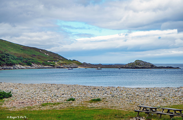
Far North
Taken from Strathan, Melness, HBM and a good week! (large please)
Talmine is a small crofting and fishing township in the Scottish Highlands, specifically in northern Sutherland. It overlooks Talmine Bay, an inlet on the western shore of Tongue Bay (also known as the Kyle of Tongue),
It's a quiet, remote spot known for its scenic beauty, with rugged coastline, rock pools, shells, a small harbour/pier, and views across the bay. The area features crofting, traditional stone buildings, and walking paths like the Talmine and Achininver Beach circuit
