Gravel Bay - Moor Cliffs Formation
East Pickard Bay panorama
East Pickard Bay - English stonecrop
Waves in Freshwater West
Druidston Haven: Cliff Section 6
Druidston Haven: Cliff Section 6 interpretation
Druidston Haven: Cliff Section 5
Druidston Haven: Cliff Section 5 interpretation
Druidston Haven: Cliff Section 4
Druidston Haven: Cliff Section 4 interpretation
Druidston Haven: Cliff Section 3
Druidston Haven: Cliff Section 3 interpretation
Druidston Haven: Cliff Section 2
Druidston Haven: Cliff Section 2 interpretation
Druidston Haven: Cliff Section 1 panorama
Druidston Haven: Cliff Section 1 interpretation
St Brides Haven solifluction deposit
St Brides Haven: colourful rocks, colourful sea
St Brides Haven - view east
Victoria Bay and Skokholm Island
Victoria Bay bedding planes in Silurian sandstones
Gateholm and Skokholm Islands
Broad Haven (S) view east to Stackpole Head and Ca…
Gravel Bay - Moor Cliffs Formation with calcretes…
Gravel Bay - Moor Cliffs Formation with calcretes…
Gravel Bay - millipede-like burrows in Moor Cliffs…
Gravel Bay - Moor Cliffs Formation 2
Gravel Bay - Moor Cliffs Formation 1
Freshwater West walkies
Spray haze over Freshwater West
Moody sky over Freshwater West
Conglomerate at Gravel Bay: close-up view 2
Conglomerate at Gravel Bay: close-up view 1
Conglomerates at Gravel Bay
Raasay: Churchton Bay, Ferry, and Ben Tianavaig on…
Raasay: Churchton Bay and Ben Tianavaig on Skye
Raasay: Inverarish from mine tramway
Raasay: No.1 Ironstone Mine adit entrance (intake)…
Raasay: No.1 Ironstone Mine adit entrance (intake)…
Raasay: No.1 Ironstone Mine adit entrance (intake)…
Raasay: No.1 Ironstone Mine tramway with silver bi…
Raasay: No.1 Mine tramway viaduct and tributary bu…
Raasay: No.1 Mine tramway viaduct - north pier
Raasay: No.1 Mine tramway viaduct piers
Raasay: Tramway junction
1/200 • f/6.3 • 16.0 mm • ISO 100 •
Canon EOS 600D
EF-S15-85mm f/3.5-5.6 IS USM
Location
See also...
Keywords
Authorizations, license
-
Visible by: Everyone -
All rights reserved
-
104 visits
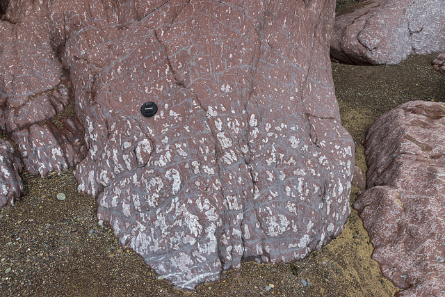
Gravel Bay - calcrete horizon in Moor Cliffs Formation


Freshwater West, Gravel Bay and East Pickard Bay
Moor Cliffs Formation in Gravel Bay.
This photo shows an even closer view of a calcrete soil development in mainly reddened mudstone beds in the Moor Cliffs Formation at the western end of Gravel Bay. The white mottled patches are irregular carbonate patches.
The lens cap is 72 mm in diameter.
Background:
The Moor Cliffs Formation overlies the Freshwater East conglomerates, seen in previous photos, and spans the boundary between the Silurian and Devonian periods. It consists of red mudstones and siltstones with occasional thin sandstone beds. These were deposited on a low-reflief floodplain at the edge of an arid continental margin, the sandstones being deposited by seasonal braided streams, the muds and silts deposited in ephemeral marginal lakes. When not inundated, the muds and silts developed carbonate-rich calcrete (caliche) soil horizons along dessication cracks, burrows and early plant root systems.
- Keyboard shortcuts:
Jump to top
RSS feed- Latest comments - Subscribe to the comment feeds of this photo
- ipernity © 2007-2024
- Help & Contact
|
Club news
|
About ipernity
|
History |
ipernity Club & Prices |
Guide of good conduct
Donate | Group guidelines | Privacy policy | Terms of use | Statutes | In memoria -
Facebook
Twitter

Sign-in to write a comment.