Yuma Quartermaster Depot river history (#0902)
Yuma Quartermaster Depot - Siphon exhibit (#0903)
Yuma Quartermaster Depot - Siphon exhibit (#0910)
Yuma Quartermaster Depot - Siphon canal (#0912)
Yuma Quartermaster Depot - Siphon canal
Yuma canal (#0855)
Yuma canal (#0858)
Yuma canal dog-1 (#0860)
Yuma canal dog-2 (#0861)
Yuma canal dog-3 (#0862)
Faces of Policing
Imperial County S-24 desert farming (#0800)
Laguna Dam - built in 1905 (#0806)
Imperial Dam, Hidden Shores, AZ (# 0807)
Imperial Dam, Hidden Shores, AZ (# 0818)
Imperial Dam, Senator Wash (#0819)
Imperial Dam, Senator Wash reservoir (#0821)
Imperial Dam, Hidden Shores, AZ (# 0809)
Imperial Dam, Hidden Shores, AZ (# 0812)
Imperial Dam, Hidden Shores, AZ bighorn (# 0813)
Imperial Dam, Hidden Shores, AZ bighorn (# 0820)
Arizona invaders (#0823)
Arizona invaders (#0824)
Yuma Quartermaster Depot (#0906)
Ft Yuma Indian Reservation, CA sunset (#0882)
Ft Yuma Indian Reservation, CA (#0878)
Ft Yuma Indian Reservation, CA mission (#0874)
Yuma Union Pacific (#0900)
Yuma Union Pacific (#0899)
Yuma Union Pacific (#0898)
Yuma Union Pacific (#0897)
Yuma Colorado River park (#0880)
Yuma Colorado river bridges ... and jumping (#0886…
Yuma Colorado river railroad bridge (#0875)
Yuma Colorado river bridges (#0872)
Yuma Wetlands (#0876)
Yuma Ocean-to-Ocean Highway bridge (#0885)
Yuma river & Territorial jail (#0871)
Yuma Wetlands (#0869)
Yuma Ocean-to-Ocean Highway bridge (#0883)
Yuma Territorial jail (#0867)
Yuma Ocean-to-Ocean Highway bridge (#0798)
Yuma Ocean-to-Ocean Highway bridge (#0794)
Yuma Colorado River park (#0792)
Yuma Colorado River park (#0789)
Location
See also...
Keywords
Authorizations, license
-
Visible by: Everyone -
Attribution + non Commercial + no derivative
-
157 visits
Yuma Quartermaster Depot river history (#0901)


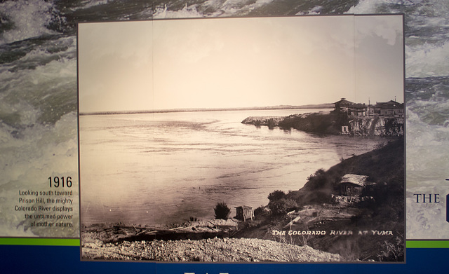
A key reason for visiting the Quartermaster Depot was its extensive history of the 'controlling' of the Colorado River. Prior to the damming of the Colorado, the river varied tremendously in volume and changed course frequently. This picture was taken after the first major dam was built in 1909 (show in later pictures) at a time when the Colorado still frequently flooded vast areas.
In the picture within the picture, the Ocean-to-Ocean bridge, which was built in 1915, would be just out of the picture at about the center right. The Territorial Prison building is on the cliff on the far side of the river in that picture. (Also see adjacent picture and pictures #0869 or #0871).
In the picture within the picture, the Ocean-to-Ocean bridge, which was built in 1915, would be just out of the picture at about the center right. The Territorial Prison building is on the cliff on the far side of the river in that picture. (Also see adjacent picture and pictures #0869 or #0871).
Clint has particularly liked this photo
- Keyboard shortcuts:
Jump to top
RSS feed- Latest comments - Subscribe to the comment feeds of this photo
- ipernity © 2007-2024
- Help & Contact
|
Club news
|
About ipernity
|
History |
ipernity Club & Prices |
Guide of good conduct
Donate | Group guidelines | Privacy policy | Terms of use | Statutes | In memoria -
Facebook
Twitter

Don Barrett (aka DBs… club has replied to ClintSign-in to write a comment.