
Hans Berger Haus
Mountaineers Rule #9
Über den Wolken: Sonnenaufgang am Untersberg (Berc…
Mountaineers Rule #10
Follow the red Points
Tightrope Walk
Marmolada, Blick zum Langkofel und Pordoi-Gruppe
Pfaffenseen
Nothing for Half-Hearted
On Top - the Classical Version
Frühmorgens an der Lamsenjochspitze
Herbst
Refuge
Abendstimmung an der Hallerangeralm
Morning has broken
Gran Zebru
In Vain - But Not For Free!
Preparing the Slopes
Helpless Answer to Global Warming
Portrait des Wilden Kaisers mit Hund und halber Ku…
Mountain windstorm and mountain chairs ++ Föhnstur…
Trentino - Upper Floor
Memory Of A Good Friend
Der Große Barmstein (851m) bei Markt Schellenberg
Hallein/ Österreich vom Kleinen Barmstein
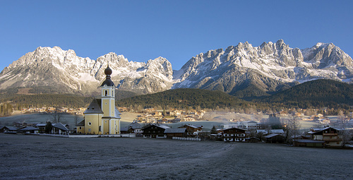
The Emperor Mountains
Going in Tyrol
Keep on going: HFF!
Interludio autunnale.
Mountaineers Rule #2 + 3
Mountaineers Rule #1
Alpine Boots - for What ?
View to Lower Kaiser Mountains
...winterlich...
# 31 ... auf dem Heimweg ...
Cascades d'Akchour
Stupas
Königsspitze - Zebru - Ortler
...auf dem Heimweg... H.F.F.
Rainbow Above the Krimml Cascade
CLOUD BANK - HAPPY FENCE FRIDAY _HFF
Wandern durchs Oytal
Blick vom Malser Höhenweg hinab nach Laatsch…
Cotton club
freedom 101
1/500 • f/11.0 • 11.0 mm • ISO 800 •
NIKON CORPORATION NIKON D7200
11.0-20.0 mm f/2.8
EXIF - See more detailsLocation
See also...
Keywords
Authorizations, license
-
Visible by: Everyone -
All rights reserved
-
1 011 visits
The Point of no Return


You may achieve the summits of the 'Kaiser Mountains' from south or from north. If you choose the northern trail, you meet the challenge, that it will take 16 to 18 hours! It's only possible in July/August. (Prior to this, there still is too much snow upon the summits, afterwards the days are too short.)
Up to the shown place ('Upper Scharlinger Ground', lefthand at the cliff is the beginning of the fixed rope route 'Kaiserschützensteig') you went 6 hours from the parking area in Kufstein. You have managed 1.200 meters of altitude until there. Here ist the 'point of no return'.
~~~~~
Man kann die Gipfel des Wilden Kaisers von Süden oder von Norden her besteigen. Wählt man die nördliche Route, muss man sich allerdings bewusst sein, dass diese Tour 16 bis 18 Stunden dauert! So was geht nur im Juli/August. (Zuvor liegt oben noch zu viel Schnee, danach sind die Tage zu kurz.)
Bis zu der hier gezeigten Stelle (Oberer Scharlinger Boden, Einstieg in den 'Kaiserschützensteig' links an der Felswand) ist man rund 6 Stunden auf den Beinen (ab Kufstein, Eingang Kaisertal) und hat die ersten 1.200 Höhenmeter geschafft. Hier ist auch die letzte Umkehrmöglichkeit.
~~~~~
The shown valley lies slightly right-hand from the beeline across the church spire to the other side of the mountains: / Der Schärlinger Boden liegt leicht rechts von der Luftlinie über die Kirchturmspitze auf die andere Seite des Kaisergebirges:
, Ko Hummel, , Ernest CH and 29 other people have particularly liked this photo
- Keyboard shortcuts:
Jump to top
RSS feed- Latest comments - Subscribe to the comment feeds of this photo
- ipernity © 2007-2024
- Help & Contact
|
Club news
|
About ipernity
|
History |
ipernity Club & Prices |
Guide of good conduct
Donate | Group guidelines | Privacy policy | Terms of use | Statutes | In memoria -
Facebook
Twitter
Deine Sommer/Herbstbilder sind auf jeden Fall immer wieder ein Erlebnis !!
s.G.Herbert
Bergfex club has replied to Wolfgang MayrWolfgang Mayr has replied to Bergfex clubSuper shot!
Bergfex club has replied to Andy Rodker clubThank you!
Andy Rodker club has replied to Bergfex clubSign-in to write a comment.