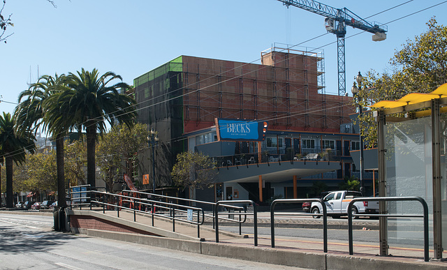
San Francisco / Castro redevelopment (# 0560)
San Francisco / Castro redevelopment (# 0561)
San Francisco / Castro redevelopment (# 0563)
San Francisco 9th & Mission – pandemic (# 0220)
San Francisco Embarcadero& Broadway – pandemic (#…
San Francisco Embarcadero& Broadway – pandemic (#…
San Francisco anti-Trump poster (# 0225)
San Francisco 9th & Mission – pandemic (# 0220)
San Francisco Embarcadero& Broadway – pandemic (#…
San Francisco Embarcadero& Broadway – pandemic (#…
San Francisco anti-Trump poster (# 0225)
SFO Bayfront park / egret / breakfast (# 0567)
SFO ANA flight / pandemic (# 0569)
SFO ANA flight / pandemic (# 0572)
SFO / pandemic (# 0565)
SFO Volga-Dnepr Airlines (# 0573)
SFO traffic jam ! / pandemic (# 0574)
SFO Bayfront park / Westin / egret (# 0575)
Monterey County / CA-198 Peachtree Ranch Wildlife…
Monterey County / CA-198 (# 0578)
Monterey County / CA-198 (# 0580)
Monterey County / CA-198 Peachtree Ranch (# 0582)
Borrego Springs, CA bighorn sheep sculptures (# 0…
San Francisco Castro Twin Peaks bar / outside (# 0…
San Francisco Castro theater (# 0549)
San Francisco Castro dining outside / justice poli…
San Francisco Castro dining (and smartphoning) out…
San Francisco Castro dining outside (# 0547)
Changes? Yes!
San Francisco Castro / homeless covid (# 0558)
San Francisco Castro / homeless covid (# 0557)
San Francisco Lands End / Golden Gate….(# 0545)
San Francisco Lands End / beach mask etiquette… (#…
San Francisco Lands End (# 0545)
Monterey Fisherman's Wharf male mask test (# 0539…
Monterey Fisherman's Wharf mask test (# 0541)
Monterey Fisherman's Wharf mask test (# 0540)
Monterey Fisherman's Wharf mask test (# 0538)
Atascadero / Lincoln environmentalist (# 0537)
Atascadero City Hall fountain (# 0536)
Atascadero Sunken Gardens and City Hall (# 0535)
Morro Bay / morning otter close-ups (# 0533)
Morro Bay / morning otters (# 0531)
Morro Bay / Morro Rock (# 0529)
Morro Bay sunset ( #0527)
Location
See also...
Keywords
San Francisco / Castro redevelopment (# 0559)


A series of four photos documenting the redevelopment/urbanization of one intersection (Market/Sanchez/15th) in the Castro; each photo contains a link to a Google Street View of the area prior to the new construction.
When this era of redevelopment started in around 2010, it didn’t seem particularly objectionable since often it was replacing an old and unused or underused building, and seemed to be providing some interesting new design. Ten years later, though, I can definitely understand why my local friends see it as the destruction of the neighborhood, of wiping out much of its culture. By being typically 5 or 6 stories (3 or more stories taller than previous), filling the entire piece of land right up to the sidewalk with a vertical box, and following a consistent angular architectural design, the style overpowers what was the defining uniqueness of the area.
In this picture, I’m surprised that Beck’s hasn’t succumbed to the redevelopment demands – it’s one of the few old fashioned motels still in existence relatively close to downtown SF. What was next to it, and is being replaced, was a funeral parlor. Below is a link to the Google Street View of the same section, taken in July, 2009.
goo.gl/maps/rQF1tyVsxq4g3LQd7
- Keyboard shortcuts:
Jump to top
RSS feed- Latest comments - Subscribe to the comment feeds of this photo
- ipernity © 2007-2024
- Help & Contact
|
Club news
|
About ipernity
|
History |
ipernity Club & Prices |
Guide of good conduct
Donate | Group guidelines | Privacy policy | Terms of use | Statutes | In memoria -
Facebook
Twitter

Sign-in to write a comment.