
Patagonian weather
Fitz Roy - weather kitchen - HFF!
El Capitán - light and shadow - 1986
Yosemite - Cathedral Rocks - 1986
Yosemite - Cathedral Rocks - 1986
Yosemite - Cathedral Rocks - 1986
Yosemite - Cathedral Rocks - 1986
Yosemite - Half Dome - 1986
Yosemite - North Dome - 1986
Zion National Park - 1986
Zion National Park - 1986
Johnson Mountain - Utah - 1986
Eagle Crags West - Utah - 1986
Pine Creek Canyon Overlook - 1986
Pine Creek Canyon Overlook - 1986
Zion NP - 1986
Zion NP - 1986
Zion NP - Angel's Landing - 1986
The Great White Throne - 1986
Laguna Azul - Torres del Paine
Speiereck - 2411 m
Kasereck - 2740 m
Kasereck - 2740 m
Weißhöhe - 2659 m
Somspitz - 2414 m
Niedere Tauern
Kasereck South Flank
Kasereck South Flank
Hochgolling - bench with a view
Mittlerer Landschitzsee - Middle Landschitz Lake
Unterer Landschitzsee - 1778 m
Unterer Landschitzsee
Unterer Landschitzsee
Niedere Tauern
Mosermandl 2680 m and Faulkogel 2654 m
Radstädter Tauern
Niedere and Hohe Tauern
Ankogel - 3252 m
Ruta 51 - getting higher
Ruta 51 - Quebrada del Toro
Ruta 51 - colorful geology
Ischigualasto - leaving on Ruta Provincial 259
Ischigualasto - Cerro Merado 1768 m
wild horses
Andes
Andes
Ruta 149 - Province Mendoza
Pampasgrass - Arroyo Upsallata
Rio Mendoza
Rio Mendozoa - Ruta 7
Rio Mendoza - Transandine Railway
Rio Mendoza - Transandine Railway
Ruta 7 - Transandine
Parque Provincial Aconcagua
Cerro Quebrada Blanca - 4499 m
Cerro Aconcagua - 6961 m
Cerro Aconcagua - 6961 m
Cerro Gemelos - 5240 m
Pico Triangular Sud - 2588 m
Paso de Uspallata - 3832 m
Cristo Redentor de los Andes
Paso de Uspallata (3832 m) - Chilean side
Valley of Rio Mendoza
Hochgolling - 2863 m
landing sites
el mirador
last glow
the long and winding
find the flower
Cerro Torre - 3128 m
Cuernos del Paine
Cerro Paine Grande
Torres del Paine - early morning
Torres del Paine
Torres del Paine - evening
Torres del Paine
Cerro Torre
islands in blue
backlight clouds
White House - Black Power
fishing red
Lofoten Shangri-La
Waiting for the sun
A very happy and peaceful New Year!
color rocks
Lefka Ori
behind
light and shadow
Mont Blanc du Tacul
in granite
Klaffernkessel
Kvænangenfjord
from zero to the summits
Lyngsalpen
Kjosen
wild land
Trollfjord
Olstinden
Reine - partially cloudy
Reine
cloud connection
Cerro Paine Grande
Torres del Paine
overview_pip's
Paine Grande
torres treeframed
torres bridgeframed
Lago Pehoé
Lago Pehoé
torres_cloudship
rusty walls
leaving El Chaltén
wilderness_fenced
Cerro Torre
Fitz Roy
far San Lorenzo
far San Lorenzo
the_throne
the throne
landscape with a peak
volcano playground
all is eroding
watch_tree
far_summit
grassy_view
Location
See also...
See more...Keywords
Authorizations, license
-
Visible by: Everyone -
All rights reserved
-
295 visits
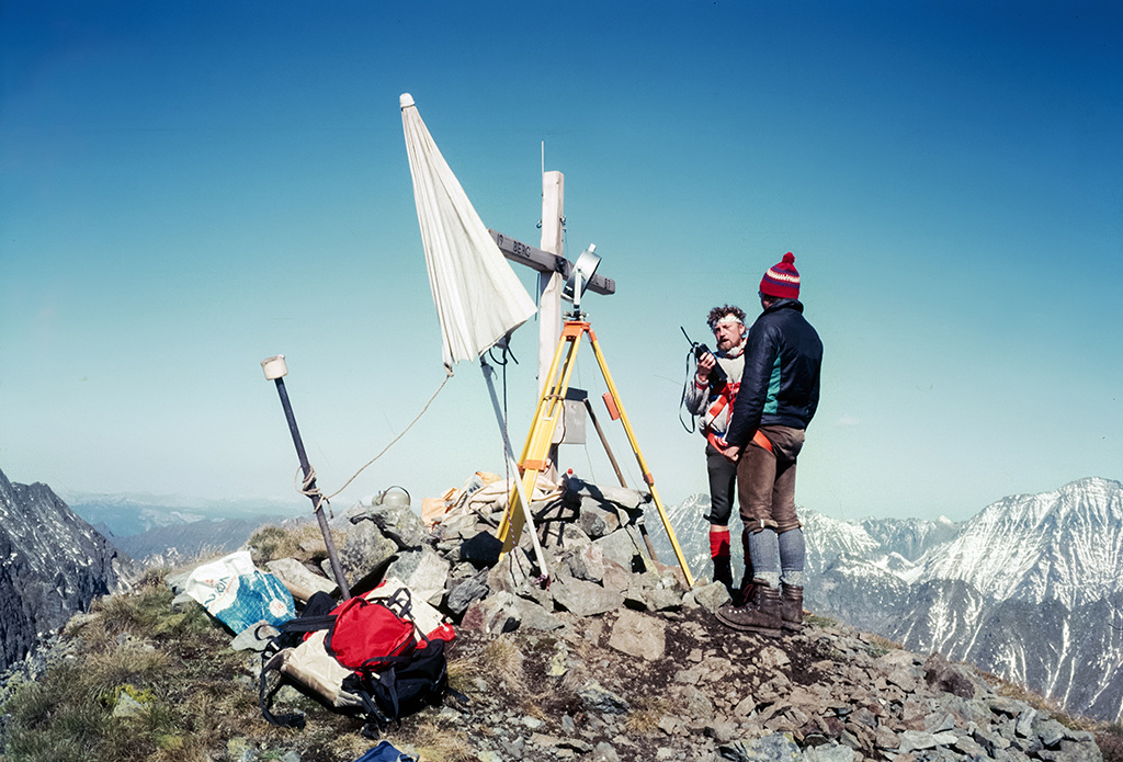
Hundstein - 2614 m


I'm back from 6 days in the "Niedere Tauern" in Salzburg and Styria.
The Hundstein is a peak in the southern part of "Schladminger Tauern", which are the highest part of the "Niedere Tauern". These mountains were always my favorite area for hiking, ski and firn glider tours. I made this peak on 11.09.1985 (solo), but you can still be sure to be alone on this very remote mountain. The peak left of the Hundstein is the Mitterspitzen (2503 m).
I added 2 scanned slides in the PiP's from 1985. It's a funny story, I reached the peak in loneliness, I met nobody the whole day. Suddenly a helicopter came and dropped 2 surveyors on the peak ;-) The 2nd PiP is a view from the peak to the north (Mitterspitzen, 2503 and Blutspitze, 2626 m), in the far background the "Hoher Dachstein".
Andreas Müller, Guy Bacca (guybac), Hervé S., Nautilus and 28 other people have particularly liked this photo
- Keyboard shortcuts:
Jump to top
RSS feed- Latest comments - Subscribe to the comment feeds of this photo
- ipernity © 2007-2024
- Help & Contact
|
Club news
|
About ipernity
|
History |
ipernity Club & Prices |
Guide of good conduct
Donate | Group guidelines | Privacy policy | Terms of use | Statutes | In memoria -
Facebook
Twitter
Sign-in to write a comment.