Scenery 2
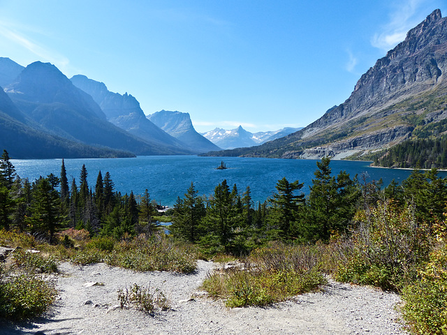
Saint Mary Lake and Wild Goose Island, Glacier National Park
We had a quick stop at Saint Mary Lake with its tiny Wild Goose Island (seen in my photo), on our drive north from Yellowstone National Park to Calgary. We had planned to drive the Going-to-the-Sun Road, but road works had already closed the road just the day before we arrived. Instead, we drove in from the west as far as we could, turned around, drove all the way south and east to eventually enter the park through the east gate.
"Saint Mary Lake is the second largest lake in Glacier National Park. Located on the east side of the park, the Going-to-the-Sun Road parallels the lake along its north shore. At an altitude of 4,484 feet (1,367 m), Saint Mary Lake's waters are colder and lie almost 1,500 feet (460 m) higher in altitude than Lake McDonald, the largest lake in the park, which is located on the west side of the Continental Divide. Here, the great plains end and the Rocky Mountains begin in an abrupt 5,000 feet (1,500 m) altitude change, with Little Chief Mountain posing a formidable southern flank above the west end of the lake. St. Mary lake has a surface area of 3,923 acres (15.88 km2)." From Wikipedia.
The lake is 9.9 miles (15.9 km) long and 300 feet (91 m) deep. The waters of the lake rarely rise above 50 °F (10 °C) and are home to various species of trout. During the winter, the lake often is frozen completely over with ice up to 4 feet (1.2 m) thick." From Wikipedia.
en.wikipedia.org/wiki/Saint_Mary_Lake
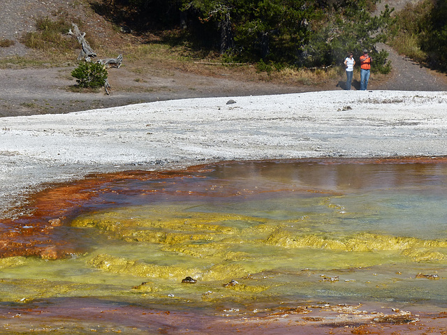
Mother Nature's paint pot
Some of the amazing natural colours formed around many of the hot springs and geysers in Yellowstone National Park. Taken at Fountain Paint Pots Trail, Lower Geyser Basin, on 13 September 2012, the third day of a wonderful week's trip with my amazing friends from England, Linda and Tony.
"Bacteria and other thermophiles (heat loving microorganisms) usually form the ribbons of color like you see here. Green, brown, and orange mats are cyanobacteria, which can live in waters as hot as 167 F (73 C). At this temperature they are usually yellow-green. They become orange, rust, or brown as the water cools. In cooler water other thermophiles may appear that will modify the colors even more. Color may also change due to stress, such as the intense sunlight of mid summer."
www.nps.gov/features/yell/tours/fountainpaint/bacteria.htm
Opal Pool, Midway Geyser Basin, Yellowstone National Park
On day three of my wonderful week's trip down to Yellowstone National Park and Grand Teton National Park with special friends from England, Linda and Tony (explanation is in my "US holiday, September 2012" set), we visited Midway Geyser Basin, along the Firehole River. Photographed on 13 September, Yellowstone. Grand Prismatic Spring, Excelsior Geyser Crater and Turquoise Pool are also at this Basin.
"Opal Pool is a hot spring in the Midway Geyser Basin of Yellowstone National Park, Wyoming. Opal Pool usually has a temperature of approximately 132 °F (56 °C). Though usually active as a hot spring, Opal Pool is considered a fountain-type geyser.
The first recorded eruption of Opal Pool was in 1947, recurring in 1949, 1952 and 1953, then ceasing. Eruptions resumed in 1979, happening at least once in most following years. Eruption heights are typically under 30 feet (9.1 m) in height, but some eruptions have been seen with heights of 70 feet (21 m) to 80 feet (24 m). Eruptions occur suddenly following visible convection in the pool, but are unpredictable. The eruption consists of one, huge, burst that throws water 20-80 feet high, making Opal Pool the largest active geyser at Midway Geyser Basin. Much smaller splashes seconds apart stretch the total duration to about 1 minute. Sometime in 2005 Opal completely drained, but it refilled as a beautiful green pool in 2008." From Wikipedia.
www.everytrail.com/guide/midway-geyser-basin-yellowstone-...
15 Sep 2012
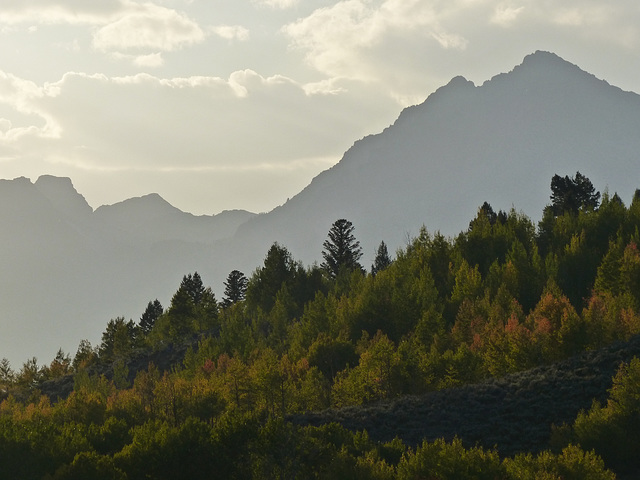
Waiting for sunset, Grand Teton National Park, Wyoming
On our recent week's trip down to Yellowstone National Park and Grand Teton National Park, we pulled off at a viewpoint and, as the time for the sun to set was approaching, we decided to stay there and witness sunset over the Grand Teton Range. While we were there, we noticed an Elk stag down in the valley in the far, far distance. There was also a photographer hiding in the bushes quite near to him. It was rather disturbing to see how stressed the stag was, taking a few steps in one direction, then turning around and looking back at the photographer, then pacing in the opposite direction, repeating continuously. Not sure that any photo is worth putting wildlife through that kind of stress.
Calgary:
"It's the dreaded "S" word for many Canadians, but parts of Alberta could be seeing SNOW this week. "A low pressure system that brought snow to the Yukon on Monday will continue to sink south into Alberta," says Brian Dillon, a meteorologist at The Weather Network. "Areas along the foothills will pick up around five centimetres of wet snow through Tuesday and by Wednesday, places like Calgary and Lethbridge may also see some scattered flurries mix in." As the low pressure system tracks over the Rockies, temperatures are set to dip as well. Most places continued to feel the summer-like conditions on Monday, but as the cold front slides through, temperatures across the Prairies will drop to the low single digits." While it may seem too early to see flurries in the forecast, Alberta is no stranger to fall snow storms. On average, Calgary usually sees around five centimetres of snow in September. The city typically picks up close to 10 cm in October as well." From The Weather Netowrk.
Artemisia Geyser, Yellowstone National Park
Seen on the third day of our week's trip down to Yellowstone National Park and Grand Tetons. Artemisia Geyser is a fountain geyser in the Upper Geyser Basin of Yellowstone National Park. We parked in the parking lot, crossed the road and walked along the Artemisia Trail for quite some distance, passing several other geysers/pools. We had hoped to find the Morning Glory pool, but were out of luck.
"Artemisia Geyser is part of the Cascade Group which includes the Atomizer Geyser. It erupts for a duration of 15 to 25 minutes once or twice per day. The fountain reaches a height of 30 feet (9.1 m). Artemisia's pool overflows quietly for many hours before an eruption, but gives no visible warning of an impending eruption until the sudden increase in overflow that marks the eruption's onset. Eruptions are accompanied by a strong underground thumping caused by steam bubbles collapsing in the geyser's channels.
Artemisia also experiences minor eruptions lasting about 5 minutes. These minor eruptions are followed by major eruptions within six hours. Minor eruptions are rare. Years may pass between episodes of minor eruptions. In 2009, intervals between eruptions ranged from 9 to 36 hours, averaging 18 hours, 43 minutes." From Wikipedia.
Grand Prismatic Spring, Yellowstone National Park, Wyoming
Another view taken at Grand Prismatic Spring. This is such an amazing hot spring, photographed on 13 September 2012, during my recent week's trip with friends down to Yellowstone National Park and Grand Teton National Park. This photo was taken from the boardwalk, but there is also a hill you can climb to get a higher view over the whole spring - we ran out of time to do this.
"The Grand Prismatic Spring in Yellowstone National Park is the largest hot spring in the United States, and the third largest in the world, after Frying Pan Lake in New Zealand and Boiling Lake in Dominica. It is located in the Midway Geyser Basin.
Grand Prismatic Spring was noted by geologists working in the Hayden Geological Survey of 1871, and named by them for its striking coloration. Its colors include blue, green, yellow, orange, red and brown, and recall the rainbow disperson of white light by an optical prism.
The vivid colors in the spring are the result of pigmented bacteria in the microbial mats that grow around the edges of the mineral-rich water. The bacteria produce colors ranging from green to red; the amount of color in the microbial mats depends on the ratio of chlorophyll to carotenoids and on the temperature of the water which favors one bacterium over another. In the summer, the mats tend to be orange and red, whereas in the winter the mats are usually dark green. The center of the pool is sterile due to extreme heat.... The spring is approximately 250 by 300 feet (80 by 90 m) in size and is 160 feet (50 m) deep. The spring discharges an estimated 560 US gallons (2,100 L) of 160 °F (70 °C) water per minute." From Wikipedia.
en.wikipedia.org/wiki/Grand_Prismatic_Spring
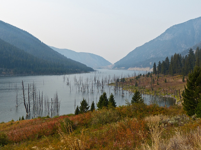
Quake Lake, Montana
Taken on the only dull day in the week I was away with friends in Yelowstone National Park and Grand Teton National Park. It was a very long day of driving, so was a good day for the weather to be less good for photography. This was one of the places we stopped at en route - Quake Lake, Montana. It had a very eerie feel to it, seeing the dead tree trunks sticking up above the surface of the lake.
"Quake Lake (officially Earthquake Lake) is a lake in southwestern Montana, United States. It was created after an earthquake struck on August 17, 1959, killing 28 people.[2] Today, Quake Lake is 190 feet (58 m) deep and 6 miles (9.7 km) long. US 287 follows the lake and offers glimpses of the effects of the earthquake and landslide. The lake is mostly within Gallatin National Forest.
The earthquake measured 7.5 on the Richter scale (revised by USGS to 7.3 and caused an 80 million ton landslide which formed a landslide dam on the Madison River. The earthquake was the most powerful to hit the state of Montana in historic times. The landslide traveled down the south flank of Sheep Mountain, at an estimated 100 miles per hour (160 km/h), killing 28 people who were camping along the shores of Hebgen Lake and downstream along the Madison River."
en.wikipedia.org/wiki/Quake_Lake
en.wikipedia.org/wiki/1959_Yellowstone_earthquake
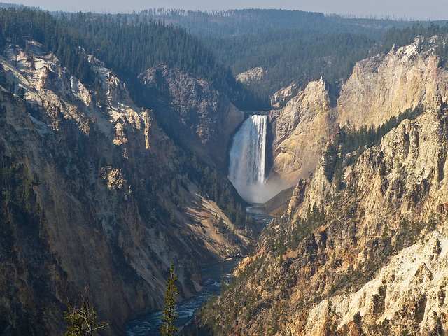
Grand Canyon of the Yellowstone
A view over the Grand Canyon of the Yellowstone, Wyoming, US, showing the Lower Falls. There are various viewpoints along the rim, giving dizzying views down into the canyon. It's a long way down! Taken on 14 September 2012 - lots of haze from several forest fires that were burning within the park. (As usual, locations marked on my maps are very approximate, more to remind myself roughly where an image was taken.)
"The Grand Canyon of the Yellowstone River slices through an ancient hydrothermal basin. The basin developed in rhyolitic lava and ash that flowed into the Yellowstone Caldera about 500,000 years ago. The river carved this spectacular canyon through the hardened lava (rhyolitic rock) and welded ash (tuff). Hot areas and steam vents still exist in the canyon. They allow heat, gases and hot water to escape from the underground Yellowstone Volcano. The canyon is about 20 miles (32 kms) long and parts of the canyon are nearly 1,200 feet (366 m) deep." Taken from a sign at the Canyon.
Loving those fall colours
I finally got out as far as Forgetmenot Pond on 27 September 2012, the far end of Elbow Falls Trail, Highway 66, west of Bragg Creek, Kananaskis. A slight exaggeration of the fall colours, as we get mainly yellow leaves, with just the very occasional yellowy-orange tree. I've only ever pulled over on this quite steep hill two or three times before, as it's not a safe place to do so. However, not another car in sight at that moment. Even though I've driven this way many times, when I come to the top of this hill, the view always takes my breath away.
Jump to top
RSS feed- Latest items - Subscribe to the latest items added to this album
- ipernity © 2007-2024
- Help & Contact
|
Club news
|
About ipernity
|
History |
ipernity Club & Prices |
Guide of good conduct
Donate | Group guidelines | Privacy policy | Terms of use | Statutes | In memoria -
Facebook
Twitter

