Scenery 2
Sandhill Slough
This is the large slough that is at the Medicine River Wildlife Centre, Spruce View, Alberta (NW of Calgary), on which five of us were lucky enough to go canoeing on 27 July 2012. Earlier in the day, we heard Sandhill Cranes in the area, but we couldn't see them.
06 Jul 2012
Layer upon layer
Just one of the many breathtaking views from the very top of Plateau Mountain, Kananaskis. Taken on 6 July 2012.
05 Aug 2012
Mirror reflection
One of the views from the Sarrail Creek Falls trail, looking out over Upper Kananaskis Lake. Taken on 5 August 2012.
Was unable to upload my photos this morning, like many other people, but I found that the old uploader worked just fine. Didn't need this hassle, as I have a very long, hot day of botanizing ahead of me today, with a very early start : ) Back later ....
Vermilion Lakes near Banff
The whole area of Vermilion Lakes is beautiful. This quick shot was taken on 12 May 2012, on the way home from a wonderful day of searching for bears with friends, Cathy and Terry.
Just south of the TransCanada Highway, the Vermilion Lakes are a series of three shallow lakes surrounded by marshland—a rich oasis for wildlife. The Vermilion Lakes drive provides classic views of Banff's signature peak, Mount Rundle (not seen in this image).
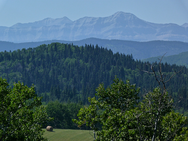
A view from Rod Handfield's
Just one of the views (zoomed in) from the property belonging to Rod Handfield, SW of Calgary and W of Millarville. We are very fortunate that Rod and his wife give us permission to explore his forest each year, searching for any new species to add to our extensive list of flora and fauna that we find there. Taken on 17 August 2012, looking westwards towards the Rocky Mountains.
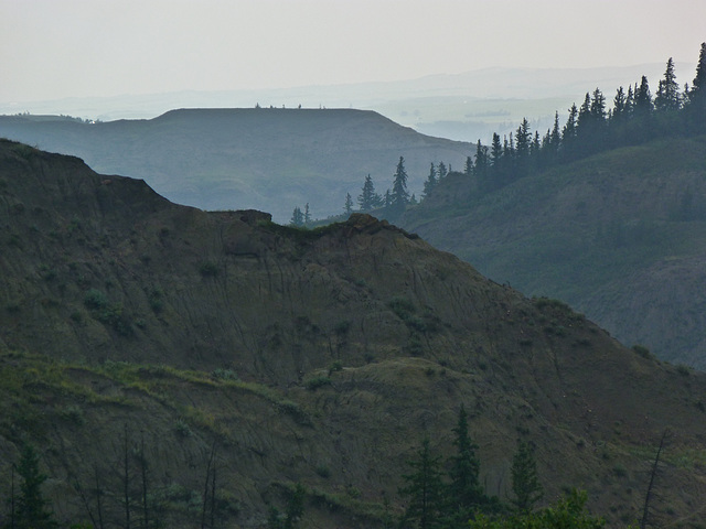
Dry Island Buffalo Jump Provincial Park in the rain
This is what the weather was like on 15 July 2012, when five of us took a long drive NE of Calgary, to spend a few hours botanizing at Dry Island Buffalo Jump Provincial Park! The day started off overcast, then turned to drizzle, which then turned into non-stop rain. There is a gate at the top of this area, which is closed when it has been, or is raining, as everywhere turns into one slippery surface. Bentonite, ancient volcanic clay ash, is prolific, and when it gets wet, it becomes very, very slippery and treacherous. Our feet slid on the surface of the gravel road that we had to walk on, and we weren't able to leave the path to explore. The gate at the top was unfortunately closed, so we had to walk all the way down to the floor of the badlands - which meant, of course, that the return walk was all uphill, which I never do well with. I'm always so thankful for very patient friends! By the time we reached the bottom, the rain was heavy and after just a few minutes, I was soaked to the skin and remained that way for the rest of the day, ha.
"Dry Island Buffalo Jump is so-named because of a flat-topped mesa called a "dry island" that rises 200 metres above the Red Deer River. In the distance you can see the grassy cliff-top of an ancient buffalo jump. Cree Indians hunted bison here by stampeding them over the high cliffs, providing enough meat, skins and other products to sustain them. The park is a mix of badlands and riparian forests where cacti and other plants typical of Alberta's grasslands are found in proximity to species normally associated with the Boreal Forest Natural Region. Prairie falcons nest on cliff faces in the park. Due to the high content of bentonite (a clay-like material) roads and trails in this area can become very slippery when wet, sometimes making them unsafe or impassable for both vehicle and foot traffic. As a result, the access road from the viewpoint to the park's day use area is often closed during wet conditions."
albertaparks.ca/dry-island-buffalo-jump.aspx
Dry Island Buffalo Jump Provincial Park
This is what the weather was like on 15 July 2012, when five of us took a long drive NE of Calgary, to spend a few hours botanizing at Dry Island Buffalo Jump Provincial Park! The day started off overcast, then turned to drizzle, which then turned into non-stop rain. There is a gate at the top of this area, which is closed when it has been, or is raining, as everywhere turns into one slippery surface. Bentonite, ancient volcanic clay ash, is prolific, and when it gets wet, it becomes very, very slippery and treacherous. Our feet slid on the surface of the gravel road that we had to walk on, and we weren't able to leave the path to explore. The gate at the top was unfortunately closed, so we had to walk all the way down to the floor of the badlands - which meant, of course, that the return walk was all uphill, which I never do well with. I'm always so thankful for very patient friends! By the time we reached the bottom, the rain was heavy and after just a few minutes, I was soaked to the skin and remained that way for the rest of the day, ha.
"Dry Island Buffalo Jump is so-named because of a flat-topped mesa called a "dry island" that rises 200 metres above the Red Deer River. In the distance you can see the grassy cliff-top of an ancient buffalo jump. Cree Indians hunted bison here by stampeding them over the high cliffs, providing enough meat, skins and other products to sustain them. The park is a mix of badlands and riparian forests where cacti and other plants typical of Alberta's grasslands are found in proximity to species normally associated with the Boreal Forest Natural Region. Prairie falcons nest on cliff faces in the park. Due to the high content of bentonite (a clay-like material) roads and trails in this area can become very slippery when wet, sometimes making them unsafe or impassable for both vehicle and foot traffic. As a result, the access road from the viewpoint to the park's day use area is often closed during wet conditions."
albertaparks.ca/dry-island-buffalo-jump.aspx
Moraine Lake
I couldn't decide whether to add a frame or not to this photo, and if I did, whether to use black or grey. In the end, I more or less just clicked on one and here it is - black, ha. This was taken yesterday, when I went with friends from England to the Banff area, Lake Louise, and Moraine Lake (seen in the image above). We had some sunshine at the beginning of our trip, but it poured with rain for the rest of the day. Took a few photos, anyway, and some seem to have come out reasonably, despite the weather and very low cloud cover. Surprisingly, the colour of the lake still looked turquoise, which is part of the magic of this very popular destination. The color is due to the refraction of light off the rock flour deposited in the lake on a continual basis. Had a great day, though, thanks to Linda and Tony!
en.wikipedia.org/wiki/Moraine_Lake
Waterton Lakes National Park, seen from the Prince of Wales Hotel
I got back last night from an absolutely amazing week away with my friends from England, Linda and Tony. Believe it or not, this was only my second holiday in about 30 years! Some of you may just remember that when my Brother in England died almost two years ago, several of my long-time friends who lived in the same city all stepped forward and helped me deal with everything long distance, from my Brother's funeral to finding everything possible in the house a good home (sold or donated). All my parents' belongings were there, too, so it was a mammoth task to go through everything and put aside every single personal item or document, which were then shipped to me here. Just one of the priceless things was when Linda went through all my Father's old movies, picked out every inch of them that she thought I would want to have, and then took them to be copied to DVD. Of course, everything was done thoughtfully and lovingly - and it still has me shaking my head that anyone could spend so much time doing SO much for someone else. There are still a few things that Linda is seeing to! Anyway, to cut a very long story short, Linda told me many months ago that she and Tony were coming to Canada again and Linda really hoped I would join them for a week getting down to Yellowstone National Park and back. Because I hadn't been away in so long, I was extremely hesitant : ) However, I did go and had the most wonderfully enjoyable (and spectacular!) time going to not only Yellowstone, but also Grand Tetons, Glacier and Waterton! Can never thank Linda and Tony enough for this! I've known Linda since she was a baby (she's about four? years younger than I am, around my Brother's age), so we had a week's precious time to "catch up". I'd only ever met Tony once, when they came to Canada for a holiday six years ago. He deserves a medal for putting up with me for a whole week!! And now I have over 2,500 images (plenty of repeats, though) to go through, lol, so please bear with me, especially when it seems that all I have to post are these holiday shots! Gosh, I miss my friends' company already!
Took this photo on 17 September 2012 from high above the lake - though it almost looks from my photo as though I was level with the water. The unique Prince of Wales Hotel was behind me, to my right.
"In 1932, Waterton-Glacier International Peace Park was formed from Waterton and Glacier. It was dedicated to world peace by Sir Charles Arthur Mander on behalf of Rotary International. Although the park has a lot of diversity for its size, the main highlight is the Waterton lakes—the deepest in the Canadian Rockies—overlooked by the historic Prince of Wales Hotel National Historic Site.
In 1979, Waterton and bordering Glacier National park in the US were designated as World Biosphere reserves, preserving mountains, prairie, lakes and freshwater wetlands ecosystems. Habitats represented in the parks' range include: prairie grasslands, aspen grove forests, alpine tundra/high meadows, lower subalpine forests, deciduous and coniferous forests.
The park is part of the Waterton-Glacier International Peace Park, designated as World Heritage Site in 1995 for their distinctive climate, physiographic setting, mountain-prairie interface, and tri-ocean hydrographical divide. They are areas of significant scenic values with abundant and diverse flora and fauna"
en.wikipedia.org/wiki/Waterton_Lakes_National_Park
Jump to top
RSS feed- Latest items - Subscribe to the latest items added to this album
- ipernity © 2007-2024
- Help & Contact
|
Club news
|
About ipernity
|
History |
ipernity Club & Prices |
Guide of good conduct
Donate | Group guidelines | Privacy policy | Terms of use | Statutes | In memoria -
Facebook
Twitter


