20170503 150121
20170503 145404
20170503 152217
20170503 151837
20170503 150624
20170503 145918
20170503 150118 001
"Dog Bone Pond"
Flooded
"Dog Bone Pond"
IMG 4244
IMG 4083
20170503 145052 001
20170503 145026 001
Wingfield Park
20170503 144923 001
Washout
IMG 4313
IMG 4306
IMG 4298
Geology in Action!
IMG 4992
Indian Creek--in flood!
IMG 4641
Indian Creek in flood, II
IMG 4635
IMG 4634
IMG 4633
Indian Creek in flood, III
IMG_3775
Flooded, III
IMG 4018
The Once and Future Lake
Portland Creek
Portland Creek
Bent
A storm in the desert--
3-28-Glen_Cyn_spillway_ig_adj
3-32-above_G_C_dam_ig_adj
3-34-Powell_above_dam_ig_adj
3-35-above_G_C_dam_ig_adj
3-27-Glen_Cyn_spillway_ig_adj
3-31-Glen_Cyn_dam_adj
18-AZ_falls
14-near_overton_adj
13-near_overton_adj
12-near_overton_adj
11-echo_bay_adj
10-echo_bay_adj
05-echo_bay_ig_adj
06-echo_bay_ig_adj
03-echo_bay_ig_adj
3-11-Boulder_Beach_ig_adj
3-30-Glen_Cyn_dam_adj
3-12-lake_view_ig_adj
3-15-lake_view_adj
3-16-Boulder_Beach_ramp_adj
3-17-Boulder_Beach_ramp_adj
3-22-Lee's_Fy_ig_adj
3-18-Boulder_Beach_ramp_adj
3-23-Glen_Cyn_Dam_adj
3-21-Lee's_Fy_adj
3-25-Glen_Cyn_dnstream_ig_adj
3-26-Glen_Cyn_Dam_adj
02-back_of_Hoover_Dam_ig_adj
11-by_Laughlin_ig_adj
10-by_Laughlin_ig_adj
09-by_Laughlin_ig_adj
08-Davis_Dam_spillways_ig_adj
Location
Keywords
Authorizations, license
-
Visible by: Everyone -
All rights reserved
-
474 visits
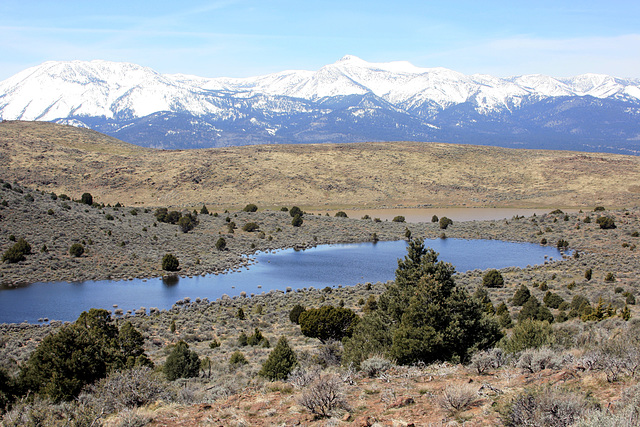
"Dog Bone Pond"


Our informal name for this unnamed, and usually dry, basin. Part of the "inner valley" basin, which is also flooded, can be seen over the low saddle in the middle distance. Looking west; the snow-clad mountains are the Carson Range. The summit to the left is Slide Mountain, while Mount Rose (10,776 ft/3285 m) is the high point just right of center. It's the centerpiece of the Mt. Rose Wilderness area. Reno, Nevada, lies in the basin off to the right of the pic.
Nouchetdu38, Don Barrett (aka DBs travels), Roger (Grisly), Andy Rodker and 4 other people have particularly liked this photo
- Keyboard shortcuts:
Jump to top
RSS feed- Latest comments - Subscribe to the comment feeds of this photo
- ipernity © 2007-2024
- Help & Contact
|
Club news
|
About ipernity
|
History |
ipernity Club & Prices |
Guide of good conduct
Donate | Group guidelines | Privacy policy | Terms of use | Statutes | In memoria -
Facebook
Twitter

www.ipernity.com/group/virtualexplore
Sign-in to write a comment.