

London Thames Barrier satellite
London Thames Barrier (#0235)
London Thames Barrier (#0203)
London Thames Barrier / Xylonite sailing barge (#0…
Coachella Valley Preserve (#0971)
Coachella Valley Preserve (#0966)
Coachella Valley Preserve (#0962)
Coachella Valley Preserve (#0961)
Coachella Valley Preserve (#0958)
Coachella Valley Preserve (#0951)
Coachella Valley Preserve (#0946)
Coachella Valley wild flowers (#0943)
Coachella Valley rain (#0938)
London Thames Barrier/Thames Clipper (#0219)
London Thames Barrier (#0215)
London Thames Barrier / Royal Wharf (#0216)
London Thames Barrier / Canary Wharf (#0217)
London Thames Barrier / Royal Wharf (#0218)
London Thames Barrier / sugar & slavery policy (#0…
London Thames Barrier / Royal Iris (#0231)
London Greenwich Old Royal Naval College (#0250)
London Greenwich Old Royal Naval College (#0251)
London Greenwich mystery picture (#0256)
London Greenwich Millenium Village (#1069)
London Greenwich Peninsular Park (#1071)
London Greenwich Antigallican (#1072)
London Albert Bridge / Cadogan Pier (#0199)
London Albert Bridge / Cadogan Pier (#0194)
London Albert Bridge and Cadogan Pier (#0190)
London Albert Bridge (#0198)
London Albert Bridge (#0196)
London Thames at Chelsea (#0178)
London Chelsea Embankment Sphinx bench (#0187)
London Thames Albion Riverside (#0186)
London Cheyne Wharf / Whistler (#0183)
London Cheyne Wharf / Chelsea Waterfront (#0180)
London Cheyne Wharf / Chelsea Yacht & Boat (#0177)
London Cheyne Wharf luxury houseboat (#0176)
London Chelsea Waterfront / Chelsea Ram (#0169)
London Chelsea Waterfront/Lots power station (#017…
London Chelsea Waterfront development (#0175)
London Chelsea Waterfront development (#0165)
London Chelsea Waterfront/London pumping station (…
Palm Springs Women's March (?) (#1386)
Palm Springs Women's March (?) (#1383)
Location
Lat, Lng:
You can copy the above to your favourite mapping app.
Address: unknown
You can copy the above to your favourite mapping app.
Address: unknown
See also...
Keywords
Authorizations, license
-
Visible by: Everyone -
Attribution + non-Commercial + no derivative
-
211 visits
London Thames Barrier (#0234)
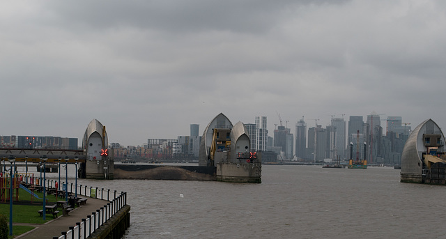

From a different angle and further away, another shot of the closed gate that’s near the south shore and of one of the wider gates in the main channel. I didn’t focus on it at the time, but the narrow gate to the left of the closed gate (a little difficult to see) indicates one of the positions that the gates can be open – they can be rotated to the top so that they are above and parallel to the water line, rather than blocking flow. The GOV link provides a good description of how the gates work.
In the distance is the development at Canary Wharf, a good illustration of the importance of the gates for protection from a tidal surge from the North Sea. The Daily Mail link below has an image of the area that would be flooded without the Thames Barrier – in that image, the China Wharf area (all in the flood zone) is the area surrounded by a large u-shaped dip in the Thames.
The Thames has a long history of flooding from tidal surges, from very heavy rains inland, and from the unfortunate times when heavy inland rain combines with very high tides. A 1953 North Sea Flood that killed 307 in the UK was the impetus to come up with a form of defense, but a means for defense was not figured out until 1966 and the construction didn’t begin until 1974, finishing in 1984. (See the Gizmodo link.) The barrier is regularly tested and was relatively lightly used as defense until recent history – per the Daily Mail link, it was used as a defense 29 times in the winter of 2013/14.
Sources:
Wikipedia: en.wikipedia.org/wiki/Thames_Barrier
Gov link: www.gov.uk/guidance/the-thames-barrier
Gizmodo link: www.gizmodo.co.uk/2016/10/behind-londons-wall-of-steel-designing-the-thames-barrier
Daily Mail: www.dailymail.co.uk/sciencetech/article-2559399/Thames-Barrier-turns-30-Stunning-images-reveal-complex-machinery-thats-shielding-London-floods.html
(Part of a documentation of 2018 exploration/reflection on Brexit and populist movements in Europe, keyword Europe2018)
In the distance is the development at Canary Wharf, a good illustration of the importance of the gates for protection from a tidal surge from the North Sea. The Daily Mail link below has an image of the area that would be flooded without the Thames Barrier – in that image, the China Wharf area (all in the flood zone) is the area surrounded by a large u-shaped dip in the Thames.
The Thames has a long history of flooding from tidal surges, from very heavy rains inland, and from the unfortunate times when heavy inland rain combines with very high tides. A 1953 North Sea Flood that killed 307 in the UK was the impetus to come up with a form of defense, but a means for defense was not figured out until 1966 and the construction didn’t begin until 1974, finishing in 1984. (See the Gizmodo link.) The barrier is regularly tested and was relatively lightly used as defense until recent history – per the Daily Mail link, it was used as a defense 29 times in the winter of 2013/14.
Sources:
Wikipedia: en.wikipedia.org/wiki/Thames_Barrier
Gov link: www.gov.uk/guidance/the-thames-barrier
Gizmodo link: www.gizmodo.co.uk/2016/10/behind-londons-wall-of-steel-designing-the-thames-barrier
Daily Mail: www.dailymail.co.uk/sciencetech/article-2559399/Thames-Barrier-turns-30-Stunning-images-reveal-complex-machinery-thats-shielding-London-floods.html
(Part of a documentation of 2018 exploration/reflection on Brexit and populist movements in Europe, keyword Europe2018)
Marco F. Delminho has particularly liked this photo
- Keyboard shortcuts:
Jump to top
RSS feed- Latest comments - Subscribe to the comment feeds of this photo
- ipernity © 2007-2026
- Help & Contact
|
Club news
|
About ipernity
|
History |
ipernity Club & Prices |
Guide of good conduct
Donate | Group guidelines | Privacy policy | Terms of use | Statutes | In memoria -
Facebook
X

.jpg)
Sign-in to write a comment.