
H.F.F. - In Gargellen (AT)
Matterhorn
H-F.F. - From Gornergrat (CH)
Behind The Scenes
Zermatt
Mystic Mountain Tour (2)
Mystic Mountain Tour (3)
The World Above 3.000 Meters
Mystic Mountain Tour (1)
Walking With Crampons
H.F.F. - At Martin Busch Hut
Short Rest At Martin Busch Hut
Martin Busch Hut
At The End Of The Modern World
Similaun Tour - The Start
Ötztal Alps (8000 x 3000 px resolution)
Unconquerable Ice Throne
Lake 'Brizzi' and Saykogel (3,355 m)
The residents of the valley (1)
The residents of the valley (2)
During The Exploration Tour
Kreuzspitze (3,455 m)
Dying Glacier
Kreuzspitze (3,455 m)
Kreuzspitze (3,455 m)
Training Hike
Glacier 'Mutmalferner'
Evening In A Hut
Evening In A Hut
The Descent
Similaun, View from 'Kreuzspitze'
This Is NOT Ötzi
'Hiking Trail' To The Ötzi Site
Similaun Hut (3,016 m)
Next Goal: Ötzi Discovery Site (3,210 m)
Ötzi Discovery Site (3,210 m)
Ötzi Monument
Ready To Conquer The Summit
Similaun Glacier
Altitude Profil Of The Similaun Tour
Similaun Glacier
Yes, It's Cold!
On Top
1,910 Meters Deep View
The Arrival
First Visual Contact To The Peak
Crossing The Similaun Glacier (1)
Crossing The Similaun Glacier (2)
The Descent
Meltwater Outflow
Glacier Runlet
Martin Busch Hut
H.F.F. - Without Smartphones
Kitzbüheler Horn (1.996 m)
In the via ferrata 'Kitzbüheler Horn' (2)
In the via ferrata 'Kitzbüheler Horn' (1)
150 Metres Below The Peak
Armrest
Natural Climbing (12 sec)
Easy Climbing (19 sec)
Happy Caged Friday
Goats at the 'Kitzbüheler Horn'
Ski Season Is Coming Soon
Climbing the 'Habicht' (2)
Climbing the 'Habicht' (3)
Climbing the 'Habicht' (4)
Climbing the 'Habicht' (5)
Climbing the 'Habicht' (6)
Climbing the 'Habicht' (7)
Climbing the 'Habicht' (8)
Climbing the 'Habicht' (9)
Climbing the 'Habicht' (10)
Climbing the 'Habicht' (11)
Climbing the 'Habicht' (12)
Climbing the 'Habicht' (13)
Climbing the 'Habicht' (14)
Climbing the 'Habicht' (15)
Climbing the 'Habicht' (16)
Climbing the 'Habicht' (17)
Climbing the 'Habicht' (18 - end)
HFF - At An Alpine Hut (2,844 m)
Wildes Mannle (3,023 m)
Glacial Lake
Trail Without Bridge
Breslau Hut (2,844 m)
Trails For Water And People
Crossing
At 3,000 m
At 3,000 m (holiday picture version)
HFF - Despite An Unfortunate Situation
Rofenkarferner (cutout)
Dying Glacier (see PiP)
Schalfkogel (3,537 m)
Similaun (3,606 m)
Mutmalspitze (3,533 m)
Sundown Over The Alps
In The Vertical (2)
In The Vertical (3)
In The Vertical (4)
The exit
Sporty Family (2)
Sporty Family (3)
Via Ferrata 'Lake Reintal' (6)
Via Ferrata 'Lake Reintal' (5) (PiP)
Via Ferrata 'Lake Reintal' - The Entrance
The Decisive Section (1)
The Decisive Section (2)
The Decisive Section (3)
H.A.N.W.E - In The Decisive Section
The Decisive Section (5)
The Decisive Section (6)
Sporty Family (1)
I Still Can
Via Ferrata 'Lake Reintal' (1)
Via Ferrata 'Lake Reintal' (2)
Via Ferrata 'Lake Reintal' (4)
Via Ferrata 'Lake Reintal' (5)
Lake Reintal
Lake Reintal (PiP)
H.F.F. - At The Lakeside
After The Climb
Getting Up
s'Schuastagangl
s'Schuastagangl
Schuastagangl Topo
Location
Lat, Lng:
Lat, Lng:
You can copy the above to your favourite mapping app.
Address: unknown
Lat, Lng:
You can copy the above to your favourite mapping app.
Address: unknown
Keywords
Authorizations, license
-
Visible by: Everyone -
All rights reserved
-
182 visits
Climbing the 'Habicht' (3,277 m) (1)
 (1)")

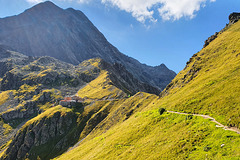
View of the Gschnitztal, a side valley of the Wipptal through which the Brenner motorway runs. You can see the small mountaineering village of Gschnitz (population 427), and at the bottom right the hikers' car park (PiP) at 1,244 metres above sea level. There is no mountain railway. The only way to climb the mountains here is under your own feet. It is accordingly quiet here.
~~~~~
Blick in das Gschnitztal, einem Seitental des Wipptals, durch das die Bernnerautobahn führt. Man sieht das kleine Bergsteigerdorf Gschnitz (427 Einwohner/innen), und ganz unten rechts den Wanderparkplatz (PiP) auf 1.244 Metern Seehöhe. Eine Bergbahn gibt es nicht. Hier kann man die Berge nur mit eigener Kraft erklimmen. Dementsprechend still geht es hier zu.
~~~~~


Translate into English
~~~~~
Blick in das Gschnitztal, einem Seitental des Wipptals, durch das die Bernnerautobahn führt. Man sieht das kleine Bergsteigerdorf Gschnitz (427 Einwohner/innen), und ganz unten rechts den Wanderparkplatz (PiP) auf 1.244 Metern Seehöhe. Eine Bergbahn gibt es nicht. Hier kann man die Berge nur mit eigener Kraft erklimmen. Dementsprechend still geht es hier zu.
~~~~~
HelenaPF, Eric Desjours, Angelofruhr, Fred Fouarge and 3 other people have particularly liked this photo
- Keyboard shortcuts:
Jump to top
RSS feed- Latest comments - Subscribe to the comment feeds of this photo
- ipernity © 2007-2024
- Help & Contact
|
Club news
|
About ipernity
|
History |
ipernity Club & Prices |
Guide of good conduct
Donate | Group guidelines | Privacy policy | Terms of use | Statutes | In memoria -
Facebook
Twitter
Bergfex club has replied to Guido Werner clubDas Bild hier entstand nach etwa 2 Stunden bei einer solchen Rast.
wie klein ist der Mensch und das, was er baut -
Bergfex club has replied to Elbertinum clubBergfex club has replied to Eric Desjours club;-))
Eric Desjours club has replied to Bergfex clubBergfex club has replied to Eric Desjours clubMit 70 geht es nicht mehr wie mit 50, auch wenn man sich oft noch so fühlt.
Den Unterschied merke ich daran, dass mich inzwischen viele überholen.
Aber meine Freude ist dennoch ungetrübt.
Sign-in to write a comment.