All the potatoes
House guest
Full moon over pigeon spikes and roof
Mars presiding
The view from my desk
Shrooms by my door
Moon at Noon reimagined
Volunteer
My end of Town
Flea beetle, I think
Water glass
Mighta bin. Coulda bi.
Staring at some birds
Poppy
Greedy-guts again
Spring 2004: Che -- your example lives; your idea…
Pedestrian bridge in Cuba. Probably Boca de Camari…
Hallowe'en Moon
One of our neighbourhood crow family
In the day's honour
Warm night, long ago
Inside the Louvre, looking out
Junks into splits
Above us, only sky
Another accidental Linaria
Lesson learnt. Maybe.
Green bottle fly in the thistledown
Cocoon and poplar leaf
Not a fish soup
Some Linaria
Lazing on a sunny afternoon
Another unexpected poppy
Unexpected poppy
Water-doctor dancing
Wondering just why the cat door to the basement is…
Self on Cathedral Street
Fruit fly doing the dog paddle in the suds of my T…
I am glad I live in the 21st century
European cabbage white butterfly sucking up some h…
Waxing crescent
Industrial yellowjacket
Gone to seed
Some bee in the fireweed
Shaky but pretty
Cabbage white eating hawkweed
Location
See also...
Keywords
Authorizations, license
-
Visible by: Everyone -
All rights reserved
-
41 visits
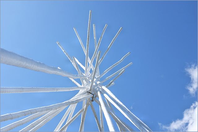
At the Peace Garden


It is always a surprise and a thrill to find artwork well away from roads and buildings.
This picture is looking up through the Peace Monument at the site of a meeting between English colonists and Beothuk local people in 1612. They all enjoyed each others' company, singing and dancing together and making plans for the next year.
The Peace Monument is the shape of the frame of a Beothuk wigwam. It sits on what is called Frenchman's Island, joined to the mainland of Newfoundland by a tiny beach. At low tide today, we walked there over that three- or four-metre-wide beach.
The water around it -- an inlet of Trinity Bay -- was named Truce Sound in 1612, in honour of the peaceful meeting. The name never stuck -- the arm was later called Bull Arm (probably for the walruses found in the early years of European exploitation there). But the "Truce" name is retained in the name of the trail we walked to get there, Truce Sound Trail and Peace Garden.
In the 1600s, that truce itself did not hold either. A long period of enmity developed, with two centuries of impoverishment, alienation, ethnic cleansing, and murder of the Beothuks. Culturally (and by most reports entirely) the Beothuk were no longer in existence by the mid-19th century. A very sad story.
And "Why," you might ask, "is it called Frenchman's Island?"
At the end of the 1600s, the French military used the island as a temporary prison for Englishmen they had captured in Trinity Bay. Those prisoners were being transported overland to the French territory in Placentia Bay. That was just five or ten kilometres south but over difficult terrain. This was a well-hidden winter home for the French forces.
The site was dug by archaeologists about fifteen years ago and today a permanent commemorative marker is under the wigwam frame.
The marker does not say who made the monument except that it was a joint work by residents of the nearby community of Sunnyside and Heritage Canada.
- Keyboard shortcuts:
Jump to top
RSS feed- Latest comments - Subscribe to the comment feeds of this photo
- ipernity © 2007-2024
- Help & Contact
|
Club news
|
About ipernity
|
History |
ipernity Club & Prices |
Guide of good conduct
Donate | Group guidelines | Privacy policy | Terms of use | Statutes | In memoria -
Facebook
Twitter

Sign-in to write a comment.