Footpath to Firs Farm
Bole Hill Plantation view to south-west
Bole Hill Plantation view to south
Lonely sycamore
Lichen on wall
Lichen on wall - detail
Spring meadow
Garden meadow
Garden wilderness
Cat's ear at ground level
Altocumulus with fallstreaks
Comet Neowise from near Burbage Bridge
Midnight clouds and stars
Lonely sycamore in September
Lonely sycamore and Wigley Farm fields
Wigley Farm fields view to Castle Dyke Lodge 1
Wigley Farm fields view to Castle Dyke Lodge 2
Wigley Farm fields view to Castle Dyke Lodge 3
Looking to Fulwood Hall
Beech in the spotlight
Handfasting Ground devastation 1
Handfasting Ground devastation 2
Early autumn colours in Rough Standhills 1
Bole Hill Plantation - 'holly smelter' slag 1
Bole Hill Plantation - 'holly smelter' slag tip 2
Bole Hill Plantation - 'holly smelter' slag tip 1
Bole Hill Plantation - 'holly smelter' stone work
Bole Hill Plantation - 'holly smelter' site
Limb Valley Bole Hill disturbed ground 4
Limb Valley Bole Hill disturbed ground 3
Limb Valley Bole Hill disturbed ground 2
Limb Valley Bole Hill disturbed ground 1
Limb Valley bluebells 2
Limb Valley bluebells 1
Clematis and bee
Japanese Maple
Greater Celandine
Bluebells focus stack
Marigold
Blue sky and Leylandeii
Summit chestnuts - sepia
Summit chestnuts
Spreading beech - sepia
Spreading beech
Winter woodland disorder
1/60 • f/8.0 • 121.0 mm • ISO 100 •
Canon EOS 600D
55-200mm
Location
See also...
Keywords
Authorizations, license
-
Visible by: Everyone -
All rights reserved
-
130 visits
Bole Hill Plantation - 'holly smelter' slag 2


Limb Valley Bole Hill lead smelting site
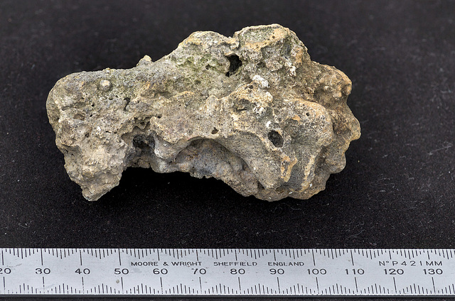
A close-up view of a piece of slag from the 'holly smelter' site slag tip, adjacent to the stone-walled remains of what was almost certainly a lead smelting bole, high up on the northern edge of the Bole Hill Plantation in the Limb Valley, and possibly of 18th or early 19th century age. The slag has a ropy and porous, almost frothy texture, indicative of its former semi-molten condition.
A small square feature, depicting a building or structure of some sort appears on the 1st edition six-inch to one mile Ordnance Survey map published in 1854. It was probably disused even then, as the map shows the plantation all around it. Subsequent editions of the maps fail to show it, although curiously the feature has been resurrected on the latest OS maps, even though the structure has long since disappeared!
There are many 'Bole Hills' in Sheffield and along the west-facing sandstone and gritstone escarpments of the Eastern Edges. Their elevated locations were ideal for wind-blown furnaces ('boles') for smelting lead ore which was brought in by pack-horses from the Peak District mines further to the west.
- Keyboard shortcuts:
Jump to top
RSS feed- Latest comments - Subscribe to the comment feeds of this photo
- ipernity © 2007-2024
- Help & Contact
|
Club news
|
About ipernity
|
History |
ipernity Club & Prices |
Guide of good conduct
Donate | Group guidelines | Privacy policy | Terms of use | Statutes | In memoria -
Facebook
Twitter

Sign-in to write a comment.