
Portland light rail, Old Town
Portland Steel Bridge
Portland Albers Mill Building
Union Station Portland
Union Station Portland
US Coast Gaurd, Humboldt
Lost Coast, Humboldt County
Arcata, CA
Pigeon Point Lighthouse
Monterety, Fisherman's Wharf
Monterey
Monterey, Harbor seals
Bixby bridge, CA-1
Camp Pendleton, birthday of Marine Corps
Camp Pendleton
San Joaquin National Cemetery
Kern Westside oil (2877)
Pyramid Hills oil field (3976)
Carrizo Plain National Monument, Soda Lake
Carrizo Plain National Monument
Bakersfield, Fox theatre
Bakersfield, Nile theatre
Bakersfield High School
Oceanside, CA
Faro, Yukon
Faro, Yukon
Taking a dip in the Arctic Ocean
Tuktoyaktuk & the DEW line
Tuktoyaktuk international airport
Tuktoyaktuk
Inuvik, NWT
Peel River crossing
Arctic Circle
Dempster Highway
Dempster Highway 560a1
Dawson City, Yukon 542a1
Dawson City, Yukon 543a1
Cassiar Highway 520a1
Telegraph Creek 515a1
Cassiar Highway 510a1
Portland Canal fjord 498a1
Hyder, Alaska 500a1
Fraser River Hells Gate 475a1
St George, UT LDS Temple 540a
Snow Canyon State Park
Location
See also...
Keywords
Authorizations, license
-
Visible by: Everyone -
Attribution + non Commercial + no derivative
-
247 visits
CA-62: Rice Army Airfield -- remembering wars


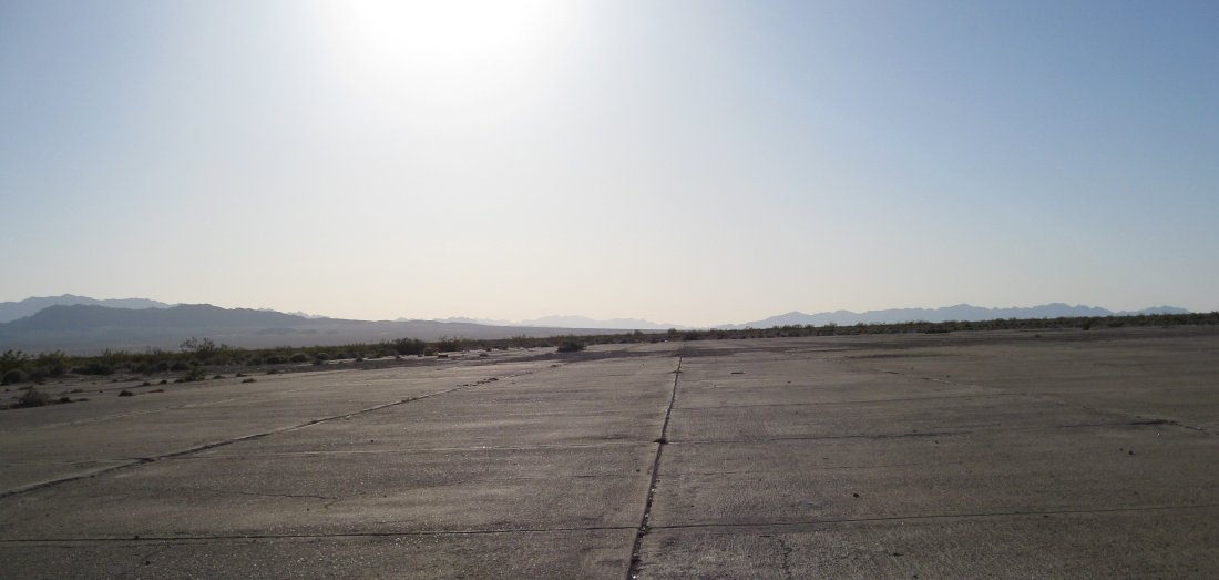
This may look boring, but it has historic importance.
Quite a bit east of Twentynine Palms, on CA 62, is the former town of Rice. There are no remains of the actual town of Rice but there are remains of an airfield. Looking up the Rice airfield on the web revealed three interesting facts. One was that the airfield had been one of about a dozen airfields that had been used in the desert during WW II and then abandoned. A second was that the airfield was much larger than one would guess just based on the immediately visible evidence. The third was the reminder of how permanent is construction in the desert. Even though very much of the airfield was apparently unpaved, quite a bit of the unpaved structure remains visible -- particularly in the satellite view (see map). From the ground, the remainder of some of the buildings are visible and a large aircraft parking area on the north end. But if you compare other markings on the ground to recent satellite photos of the site, you can clearly still tell the location of various taxiways even though the airport was decommissioned at least 50 years before these pictures were taken. This picture is of the only visible paved area of the airport, a large pad with tie-down rings, on the north end. In the satellite photo, this is the white pad on the north end.
Despite the featureless quality of these pictures, it is important to step back in time and reflect on what it was like to be here in the vast and empty desert, learning to fly and preparing for combat missions (and possible death) in WW II.
This would have been the late afternoon view of many who were training for war.
****
In January, 2013, plans were announced to convert the former airfield to a solar energy plant
slgwv has particularly liked this photo
- Keyboard shortcuts:
Jump to top
RSS feed- Latest comments - Subscribe to the comment feeds of this photo
- ipernity © 2007-2024
- Help & Contact
|
Club news
|
About ipernity
|
History |
ipernity Club & Prices |
Guide of good conduct
Donate | Group guidelines | Privacy policy | Terms of use | Statutes | In memoria -
Facebook
Twitter
Don Barrett (aka DBs… club has replied to slgwv clubslgwv club has replied to Don Barrett (aka DBs… clubDon Barrett (aka DBs… club has replied to slgwv clubslgwv club has replied to Don Barrett (aka DBs… clubDon Barrett (aka DBs… club has replied to slgwv clubSign-in to write a comment.