
Cow in Cream
Here and Now . . . ?
H.F.F. - Well Strapped
The Eastern Chiemgau Alps
Springtime Meets Wintertime
Watzmann
Professionals
Descent from Watzmann
Südspitze of Watzmann
What Goes Up Must Come Down
Go on, or Back?
Hocheck Refuge
Hocheck Summit Cross
Crossing Watzmann
Alpine Hut Watzmannhaus
Watzmann
Difficulty A/B
The Ridge
Fake News
H.F.F in the "Free State of Bavaria"
A Warmly Welcome to Tyrol
Flight In The Sun
Highest 'beer garden' of Germany
Sundown Over The Alps
Waiting For Sunrise
Birth Of A New Day
Scree Running
The Highest Point of Austria
Crossing the Alps (7)
Autumn in Tyrol
Better NOT Barefooted in Wintertime
Exaltation
Loyal Friendship
* Christmas Mountains *
Tre Cime
Looking Back
It's Your Own Risk
Mountaineers Rule #14
Kiss of the Morning Sun
Τ = Toleranz
My Dream
To the Mitterhorn via "Naked Dog"
Mitterhorn, 2.506m
Lofer Mountains from the West
Mountaineers Dreams
Chapel St. Antonius
Lofer Mountains
Solitude !
Solitude ?
Monte Casale
Via FERRATA
The WALL
H.F.F with Che Guevara
Lago di Toblino
Monte Casale
Follow the red Points
1/400 • f/16.0 • 90.0 mm • ISO 200 •
NIKON CORPORATION NIKON D7200
18.0-250.0 mm f/3.5-6.3
EXIF - See more detailsLocation
See also...
Keywords
Authorizations, license
-
Visible by: Everyone -
All rights reserved
-
1 033 visits
* Embossment *


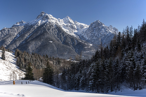
Mitterhorn, 2.506m, Lofer Mountains (Tyrol, Austria)
~~~~~
Was man kaum glauben mag: Vom Gipfel gibt es eine Abfahrmöglichkeit für Tourenskigeher, die Diagonalrinne, welche schräg nach rechts unten in die Schneegrube führt. (Das ist im Bild dort, wo der leichte Nebel liegt.) Von dort geht es dann - nur unwesentlich leichter - weiter nach unten, bis ins Lastal nach St. Ulrich am Pillersee. Einstufung "anspruchsvoll, felsdurchsetzt, Stellen bis 45Grad, Stürze nicht empfehlenswert, Nachahmung auf eigene Gefahr". Na denn, wer's braucht . . .
Tour Nr. 5 aus: www.schmidt-zabierow.at/media/Skitourenauswahl.jpg
~~~~~
The Lofer Mountains:
Translate into English
~~~~~
Was man kaum glauben mag: Vom Gipfel gibt es eine Abfahrmöglichkeit für Tourenskigeher, die Diagonalrinne, welche schräg nach rechts unten in die Schneegrube führt. (Das ist im Bild dort, wo der leichte Nebel liegt.) Von dort geht es dann - nur unwesentlich leichter - weiter nach unten, bis ins Lastal nach St. Ulrich am Pillersee. Einstufung "anspruchsvoll, felsdurchsetzt, Stellen bis 45Grad, Stürze nicht empfehlenswert, Nachahmung auf eigene Gefahr". Na denn, wer's braucht . . .
Tour Nr. 5 aus: www.schmidt-zabierow.at/media/Skitourenauswahl.jpg
~~~~~
The Lofer Mountains:
* ઇઉ *, autofantasia, ColRam, and 16 other people have particularly liked this photo
- Keyboard shortcuts:
Jump to top
RSS feed- Latest comments - Subscribe to the comment feeds of this photo
- ipernity © 2007-2024
- Help & Contact
|
Club news
|
About ipernity
|
History |
ipernity Club & Prices |
Guide of good conduct
Donate | Group guidelines | Privacy policy | Terms of use | Statutes | In memoria -
Facebook
Twitter
Marie-claire Gallet has addedVu et admiré sur Fée NATURE
"Essis leichta auffi z'kaxln, als wie an g'scheits Bild davon zu machen."
Bis zu dem Fotopoint ist man nämlich volle zwei Stunden auf Tourenski unterwegs.
(Aufnahme mit leichtem Reisezoom und Polfilter.)
Beste Grüße
Tanja
Sign-in to write a comment.