Photography - Rephotography
Folder: Miscellany
Turnoff to Boulder City, Nevada.
Looking southwest. The top photo is from the L.F. Manis collection (#100-1113) at the University of Nevada, Las Vegas, and was taken ca. 1935. I took the lower photo on 13 June 2011.
There's been just a bit of development! I think the exact original photography stance is now under the modern highway. Note, however, that not only is the big water tank on the skyline still there, but also the building skylined on the knoll to the right (outlined). I think it was one of the government's original offices for the Boulder Canyon Project (Hoover Dam).
Mt. Wheeler, Spring Mountains.
From Indian Springs looking south. Top photo is from the Chester R. Longwell collection (#311-0117) at the University of Nevada, Las Vegas, and was taken ca. 1925. The lower photo is by me, 10 June 2011.
Mt. Wheeler is the skylined peak to the left of center. There has been some development in the intervening 85 years, although this part of Indian Springs seems abandoned. Perhaps it was base housing back around WWII. There's a big air force base behind me (Creech) which is still very active--you can often see Predators flying there--and which dates back to WWII.
Note that this is NOT the Mt. Wheeler in Great Basin National Park, although it's named after the same explorer.
Mt. Wheeler, Spring Mountains, Nevada
Looking south. Top photo is from the Chester R. Longwell collection (#311-0116) at the University of Nevada, Las Vegas, and was taken ca. 1925. The lower photo is by me, 10 June 2011.
Wheeler Pass is the prominent notch to the left of Mt. Wheeler, the peak in the middle. This is only a mile or so beyond Indian Springs, to the north on US-95, but here there are very few changes. The only new cultural feature is the barbed-wire fence! The exact position of the original photo is probably covered by the modern highway.
Note that this is NOT the Mt. Wheeler in Great Basin National Park, although it's named after the same explorer.
Frenchman Mountain, outside Las Vegas.
Looking northeast. The top photo is from the Chester R. Longwell collection (#311-0071) at the University of Nevada, Las Vegas, taken ca. 1925. The bottom photo is by me, 14 June 2011. The rephoto location is on Russell Road, on the on-ramp leading up to the 515 freeway. Obviously it's thus a bit higher than the original stance, but that makes the comparison possible because we can see over all the development. The Clark Generating Station is just off the photo to the left.
Frenchman Mountain is a classic fault-block mountain that has starred in a number of geology textbook illustrations.
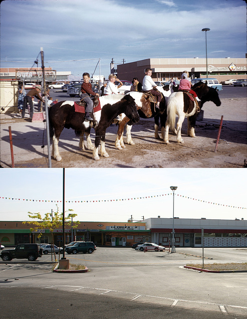
Twin Lakes Plaza, Las Vegas, NV, 1960 and 2011
Another view, roughly northeast. Still winter, 1960, in Las Vegas on Rancho Rd. northeast of the intersection with Washington. Here the amount of development in the last 50+ years is much more obvious. Still, the part of the shopping center that was there in 1960 has survived. The old Sprouse-Reitz variety store (this was long before Big Box retail) is now a beauty supply store.
Again, the little boy in the white sweater is me, the girl in the white sweater is my kid sister, and I don't know who any of the other children are.
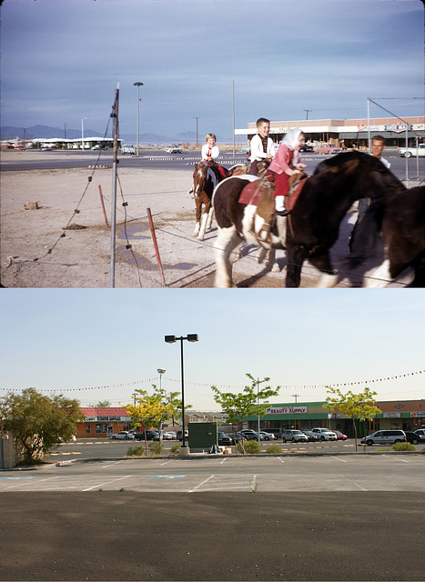
Twin Lakes Plaza, Las Vegas, NV, 1960 and 2011
Winter, 1960, in Las Vegas on Rancho Rd. northeast of the intersection with Washington. Looking more or less east. It's utterly amazing that this late 1950s shopping center has survived, but it has. The stores are all different, and they've filled in some stores in the vacant space between the old Faiman's Market and the rest of the center (that had already happened by the mid 1960s, IIRC), but the buildings are still there.
I didn't quite get the angle right on this one, due to squinting at the monitor in bright sun. It's pretty close, though.
The little boy in the white sweater on the pony in the middle is yours truly, and the girl behind me, also in a white sweater, is my kid sister. I have no idea who the other kids are. Yes, another thing that dates the photo--pony rides in Twin Lakes Plaza!
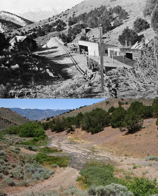
Mahoney mine, then & now
Top photo is courtesy Nevada Historical Society; bottom photo is by me, 14 July 2011. The date on the original is given as "ca. 1920" but judging from production records (Nevada Bureau of Mines & Geology Bull. 70, 1969) it's probably more like 1910. It's not much earlier than that, though; note the power pole (outlined). By and large mines weren't electrified till after 1900. In fact, the power pole looks very similar to the one I photographed about a mile east:
www.flickr.com/photos/34117538@N08/3348753733/in/set-7215...
and maybe this was one of the destinations on that line.
I didn't get the angle exactly right, but it's close enough to give the flavor. The water on the old dump (the flat area in the middle) is flowing out of the old adit. Like many such sites, it's now a spring.
This was a minor gold producer.
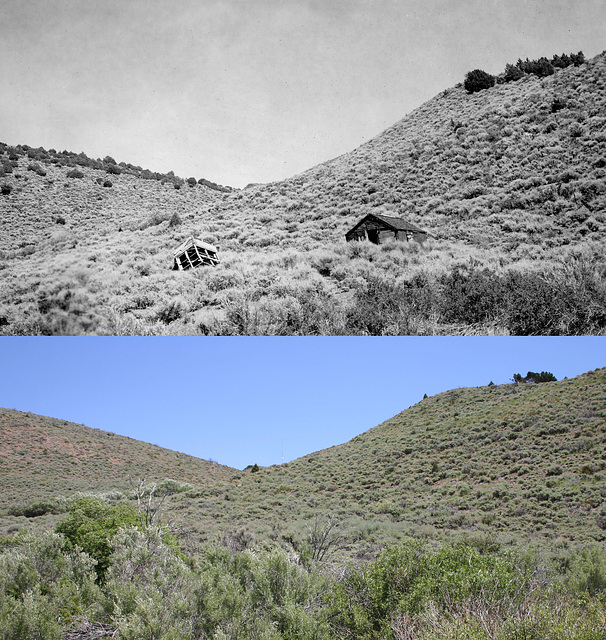
Near Jumbo
About a half mile downstream from the main town site, just above the old mill foundation:
www.flickr.com/photos/34117538@N08/5552654863/in/set-7215...
Upper photo is courtesy Nevada Historical Society, and is probably by Gus Bundy, ca. mid 1930s; lower photo is by me, 14 July 2011. The photos are looking roughly east up a side canyon off Jumbo Grade.
Not much left of the old buildings! In striking contrast to the view above Jumbo itself, there were also more piñon/juniper trees in the 1930s than now, especially on the slope to the left. This evidently is the result of a fire a few decades back; there are lots of snags on that slope, and some are even skylined in the modern photo (view at large scale). It's also possible that that fire finished off what was left of the buildings.
There is a modern cultural feature: a tall communications tower right on the range crest to the right of the bluff peeking out in the middle of the canyon (outlined; view large). It was built only a couple of years ago.
The photo stance was hard to recover; it's now down in the steep gully formed by the 1997 flood. Apparently there had been some surface build-up due to sedimentation since the 1930s that was subsequently channeled by the flood. I'm sure Bundy took his photo from what then was the ground surface.
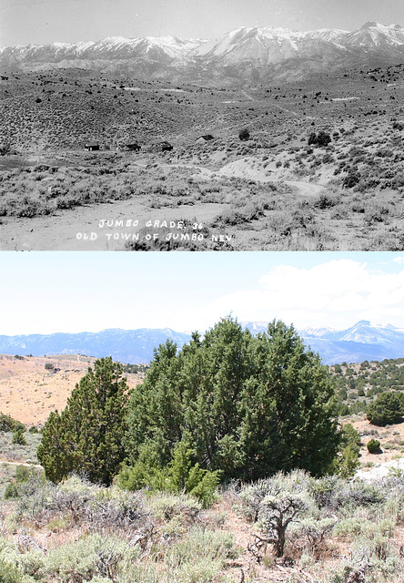
Jumbo then & now
Jumbo, Nevada, ca. 1936 and 2011. Top photo courtesy of Nevada Historical Society (uncredited postcard); bottom photo by me, 14 Jul 2011.
In fact, the actual original photo stance is somewhere under those juniper trees in the foreground. This was a hard photo to recover, and not just because of all the vegetation that's grown up. It turns out the road in the foreground of the original pic no longer exists, too. It's been realigned to run up along the wash at right, presumably because of washouts over the years. I ended up matching the stance by lining up the rocky outcrop on the left of the hill in the middle distance (outlined) against the Carson Range (the skyline), and also by comparing the location of the distinctive whitish rhyolite roadcut in the middle of the picture.
I've put a photo from a different position, from about 100 yards southeast, in the comments that gives a much better flavor of the changes. None of the buildings or surface mine workings exist now, and the piñon/juniper forest has made a huge comeback. I imagine the trees had all been logged off in the 1860s to fire the boilers in Virginia City, about 5 miles behind me over the Virginia Range. The wildfire scar on the left in the modern photo dates to a few years ago. It was lightning-caused, IIRC.
I've also highlighted the headframe of the Pandora shaft. This shaft was filled in several years back by the BLM, as part of their mine-safety program.
Jump to top
RSS feed- Latest items - Subscribe to the latest items added to this album
- ipernity © 2007-2024
- Help & Contact
|
Club news
|
About ipernity
|
History |
ipernity Club & Prices |
Guide of good conduct
Donate | Group guidelines | Privacy policy | Terms of use | Statutes | In memoria -
Facebook
Twitter


