Photography - Rephotography
Folder: Miscellany
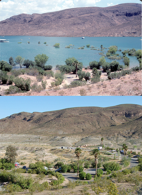
Flood vs. Drought: Echo Bay, Lake Mead, Nevada
Top photo is from July 1983, during the record high lake level; bottom photo is during the current drought (July 2010). Note that the palm trees that were flooded, some up to their fronds, in 1983 not only survived but have grown a lot in the intervening 27 years (outlined).
Here's a link to the top photo alone:
Echo Bay, flood of 1983
with some more information.
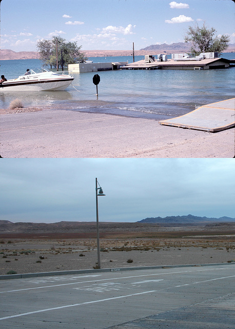
Flood vs. Drought: Overton Beach, Lake Mead, Nevada
Top photo is from July 1983, during the record high lake level; bottom photo is during the current drought (Dec 2009). Nearly all the cultural features are different; I had to use the mountains on the skyline as the referents. Evidently the building was so damaged as to be demolished after the flood. The trees were probably removed at the same time. Here's a link to the upper photo alone:
www.ipernity.com/doc/289859/23604901/in/album/453963
with some additional information.
Btw, the site of St. Thomas
www.ipernity.com/doc/289859/23558737
is off the photos to the left--in about 100 ft of water in 1983!
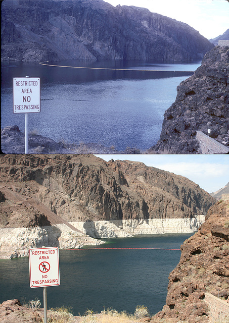
Flood vs. Drought: Lake Mead Upstream from Hoover Dam
Looking toward the Nevada side. Top photo is from July 1983, during the record high lake level; bottom photo is during the current drought (July 2009). Note that the "No Trespassing" sign has been changed as well.
Here's a link to the upper photo alone, as well as to more information:
www.ipernity.com/doc/289859/23604893/in/album/453963
Flood vs. Drought: Overton Beach II, Lake Mead, Nevada
This is a bit to the right of the other photo from Overton Beach. The mountains in the background on the right are the Virgin Mountains, which are just on the Nevada side of the NV-AZ state line. As in the other photo, I had to key off the mountain skyline to match the vantage point, because the only cultural feature remaining is the pavement! The river visible at the right in the 2009 photo (below) is the Virgin River, which flows south out of Utah on its way to join the Colorado. Lake Mead is so low that the river has returned to its channel. The Overton Arm of Lake Mead is the flooded lower valley of the Virgin River, and at high water it extends up to here.
Here's a link to the upper photo alone:
www.ipernity.com/doc/289859/23604899/in/album/453963
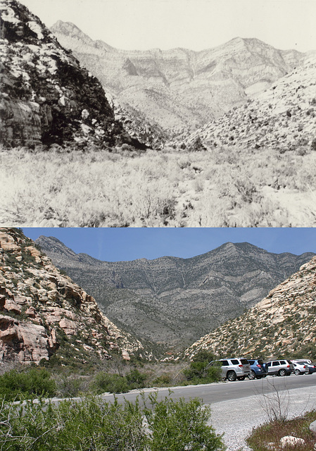
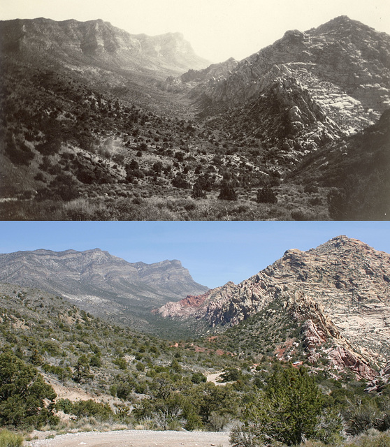
Red Rock Wash - Willow Spring Gap
Upper photo is from 1908(!), from the Helen J. Stewart collection (#104-0220) at the University of Nevada, Las Vegas; the lower photo is by me, on 15 April 2011. Both photos are looking roughly west.
Helen J. Stewart was a Las Vegas pioneer, and quite a lady. Here's a link to her bio:
www.1st100.com/part1/stewart.html
Not too many changes; just the pavement and parking for the Willow Spring picnic area. Good thing the Red Rock area was protected years ago, or there'd be McMansions carved out of those hills!
Red Rock Wash
Upper photo is ca. 1925, from the Chester R. Longwell collection (#311-0174(2)) at the University of Nevada, Las Vegas. I took the lower photo on 15 April 2011. Photos are looking pretty much due north.
Longwell was the "grand old man" of southern Nevada geology. He started mapping on horseback in 1919, and his last published paper was in 1974. He recognized and defined most of the large-scale features of the geology around Las Vegas and in Clark County that we now take for granted.
The road I'm on (which evidently didn't exist when Longwell took his photo) is a barely passable Jeep track, still open to motorized traffic, that goes through Willow Spring gap in the Red Rock escarpment along Red Rock Wash, and then south behind the escarpment up a steep canyon. It eventually exits into Lovell Canyon road and the Pahrump highway. However, structures like stonework around culverts indicate this road was once in much better shape, and it may have been a CCC (Civilian Conservation Corps) project from the 1930s.
The upper part of Red Rock Wash follows the swale in the upper center of the photos. It marks the trace of the Keystone Thrust, which Longwell named, where gray Paleozoic limestones have been shoved over the light-colored sandstone to the east. The thrust also continues to the south, parallel to and near the road I'm on.
There are not many changes visible in almost 100 years. The road is the only obvious change. Other than that, the vegetation seems sparser in the 1920s. In particular, there's now a heavy growth of piñon-juniper in upper Red Rock Wash.
Lower Lee Meadows, Lee Canyon, Spring Mountains, Nevada
Looking west toward Charleston Peak (skylined on the right). The upper photo is from the Chester R. Longwell collection (#311-0035) at the University of Nevada, Las Vegas, and was taken ca. 1925. I took the lower photo on 15 June 2011.
The most striking change is that the trees are taller! The Lee Canyon highway is also barely visible to the left of center in the modern photo (outlined). And, of course, there are no animals grazing right now, but I'm sure that you can still see them sometimes. ;)
Highway to Hoover (Boulder) Dam, Nevada
Looking northeast. The upper photo is from the L. F. Manis collection (#100-3348) at the University of Nevada, Las Vegas, and was taken in the early 1930s. The lower photo is by me, 13 June 2011.
The highway isn't all that different, but there are now lots of high-voltage transmission towers of various vintages. I think the steel frame tower on the left dates from the dam's construction, while the pylons on the right are considerably newer. The edge of the new Hoover Dam Bypass Bridge is visible at the extreme right in the modern photo (outlined).
Boulder City turnoff, Nevada
Looking west. The upper photo is from the L.F. Manis collection (#100-1112) at the University of Nevada, Las Vegas, and was taken ca. 1935; I took the lower photo on 13 June 2011. The exact original photo position is unrecoverable because of all the road construction and housing development. (I'm standing on a built-up terrace for a development behind me.) Again, the amount of development in the last 75 years is astonishing.
Jump to top
RSS feed- Latest items - Subscribe to the latest items added to this album
- ipernity © 2007-2024
- Help & Contact
|
Club news
|
About ipernity
|
History |
ipernity Club & Prices |
Guide of good conduct
Donate | Group guidelines | Privacy policy | Terms of use | Statutes | In memoria -
Facebook
Twitter

