

Wupatki National Monument 1646a
Wupatki National Monument 1647a
Wupatki National Monument 1651a
Wupatki National Monument 1652a
Wupatki National Monument 1653a
Wupatki National Monument 1655a
Wupatki National Monument 1656a
Wupatki National Monument 1657a
Wupatki National Monument 1658a
Wupatki National Monument 1659a
Cameron, AZ Suspension Bridge 1662a
Cameron, AZ Suspension Bridge 1663a
Cameron, AZ Suspension Bridge 1664a
Cameron, AZ Suspension Bridge 1665a
Cameron, AZ Suspension Bridge 1666a
Cameron, AZ Suspension Bridge 1670a
Cameron, AZ Suspension Bridge 1671a
Cameron, AZ Suspension Bridge 1669aa
Cameron, AZ Suspension Bridge 1669a
Cameron, AZ Suspension Bridge (1672)
Navajo National Monument 1673a
Navajo National Monument (1682)
Navajo National Monument 1683a
Sunset Crater Volcano NM 1644a
Sunset Crater Volcano NM 1642a
Sunset Crater Volcano NM (1641)
Sunset Crater Volcano NM 1640a
Sunset Crater Volcano NM 1638a
Sunset Crater Volcano NM 1636a
Kingman, AZ airport 1635a
Kingman, AZ airport 1634a
Kingman, AZ airport 1632a
Kingman, AZ airport 1631a
Needles, CA El Garces 1629a
El Garces, Needles, CA 1628a
Needles, CA 1627a
CA-62, Camp Rice 1626a
CA-62, Camp Rice 1625a
Rice, CA 1624a
Rice, CA 1623a
Desert Center, CA (1615a)
Desert Center, CA (1614a)
Desert Center, CA (1613a)
Desert Center Eagle Mountain Railroad caboose, Des…
Eagle Mountain Railroad (1606a)
Location
Lat, Lng:
You can copy the above to your favourite mapping app.
Address: unknown
You can copy the above to your favourite mapping app.
Address: unknown
Keywords
Authorizations, license
-
Visible by: Everyone -
Attribution + non-Commercial + no derivative
-
211 visits
Wupatki National Monument 1645a
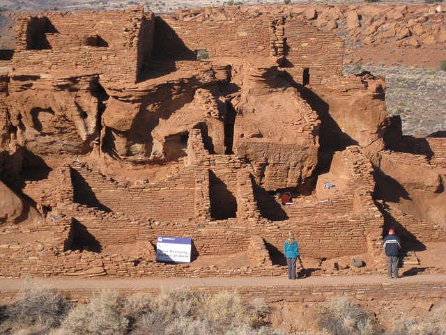

I've visited Wupatki National Monument at least 3 times over the past 20 years and found each visit to be worthwhile. Every time I've visited there have been relatively few other visitors, thus it is one of the few Native American ruins where it is quiet enough to be able to spend time reflecting on what life must have been like for the original inhabitants.
The vistas to the east are of seemingly uninterrupted grasslands and canyons going on forever, thus adding to the sense of spectacular isolation.
Per the National Park Service website, the ruins date back to 1100's when the area was most densely populated. The eruption of a nearby volcano (see Sunset Crater photos) forced populations to move and at the same time the volcanic ash held moisture in the soil so that crops were easier to grow. Settlement here lasted until about 1250.
Updated 7/13/2014: Per the link below, excavation began in 1933 and much of the early labor for excavation and stabilization of the ruins was provided through two New Deal agencies: Civil Works Administration and Civilian Conservation Corps.
www.library.arizona.edu/contentdm/newdeal/brochure.pdf
- Keyboard shortcuts:
Jump to top
RSS feed- Latest comments - Subscribe to the comment feeds of this photo
- ipernity © 2007-2026
- Help & Contact
|
Club news
|
About ipernity
|
History |
ipernity Club & Prices |
Guide of good conduct
Donate | Group guidelines | Privacy policy | Terms of use | Statutes | In memoria -
Facebook
X


Sign-in to write a comment.