

Martin M. Miles' photos

Baillargues - Saint-Antoine
| |
|
|
The chappel "Saint-Antoine-de-la-Cadoule" is - a garage since decades and part of a farm. We learned from the owners, that the 12th century-chappel once belonged to a Knights Templar. Note the nice lombard band under the roof. The wooden door, seen behind the 2CV, is only three generations old.
Baillargues - "Course Camarguaises"
| |
|
|
|
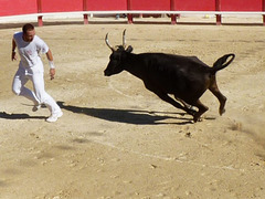
The "Course Camarguaises", we could see in the arena of Baillagues, has nothing to do with Spanish-style bullfighting. This is a bloodless spectacle. The "raseteur" has to snatch a rosette from the head and small bands from the horns of the bull. The "raseteurs" have to be very fast and pretty smart.
Baillargues
| |
|
|
|
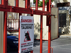
Stayed in Baillargues and learned that not only Pamplona in Spain has a "Running of the Bulls". Baillargues has that too - and many other villages in the Languedoc. When the bulls run, the inner part of the village is secured by iron grills. When I took that photo, the gates were still open - and no bulls around.

Near Baillargues
| |
|
For many kilometers the GR653 runs parallel to the A9-Motorway (Languedocienne), so the "singing" of the cicadas mixes with the noise of the cars. I had to cross this ford, but the little stream was dried out. Just a few minutes later a pretty long Green Whip Snake crossed my way. I was way too slow, to portray the snake.

Cigale - Cicada
| |
|
To walk in Southern France during summer means to hear the constant noise of these insects. The male cicadas "sing" as soon, as the sunshine has produced a certain temperature - and they will not stop until sunset. These insects do not even have a siesta over noon, like most others.
Villetelle - Pont d'Ambrussum
| |
|
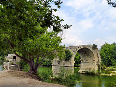
An arch of a Roman bridge crossing the Vidourle near Villetelle. Built within the 1. century BC - and once consisting out of upto eleven arches, this bridge was part of the Via Domitia linking Italy and Spain. The ruins of the Roman Oppidum of Ambrussum are being excavated currently. When Gustave Courbet painted this bridge in 1857, two arches were left. The second one got lost in a flooding 1933 - so this is the last.
Approaching Villetelle
| |
|
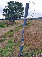
This red/white mark is the navigation-system, as it indicates the "Grande Randonnée" (here GR653)
I was on. But I was not the only creature using this kind of navigation . Hundreds of small snails had followed the sign as well - vertically.

Gallargues-le-Montueux
| |
|
This building was the "Hopital St. Jaques" during the middle ages. It has changed over the time - only the traces of some former windows can bee seen. I learned from the blue plate over the door, that it was from 1789 on used as "asile ouvert aux indigents de la commune et aux vagabonds". An asylum open to the needy of the town and vagrants.

Vauvert - Autour d´un Olivier
| |
|
Stayed in "Autour d´un Olivier", a lovely and very comfortable "Chambre d’hôte" in Vauvert.
The center of it is this yard around a 700 years old olive-tree. There is even a swimming-pool!
Mercy beaucoup for your hospitality, William!
Of course, there is a website:
www.fr.autourdunolivier.com/main.html

Approaching Vauvert
| |
|
Having crossed lots of orchards (peaches and nectarines) I walked next to vinyards again. Straight on. On the right the irrigation channel "Bas-Rhône Languedoc". The water from this channel forms the landscape.

St. Gilles - Abbey
| |
|
In a niche of the crypt is the grave of Pierre de Castelnau, his remains were burnt during the Regilious Wars in 1562, so it is probably empty. - 1202 he was appointed by Pope Innocent III. as a legat for the suppression of the Cathar heresy in Southern France. What he did, he suspended the bishops of Toulouse and Béziers and excommunicated Raymond VI. of Toulouse. Pierre de Castelnau was assassinated on 15.01.1208, allegedly by an agent of Raymond, in the nearby village of Trinquetaille. This assassination triggered the Albigensian Crusade, as now Innocent III declared a crusade, offering the lands of the Cathars to any French nobleman willing to take up arms. This War lasted for 20 years. After that decades many villages and towns were totally destroyed and vast areas in Southern France were depopulated.

St. Gilles - Abbey
| |
|
The huge crypt of the former benedictine monastry St. Gilles. In the foreground the tomb of St. Gilles. Three walking sticks are placed there, as still pilgrims flock here - as they did in the middle ages.
This crypt has not been destroyed during the Wars of Religion and the Revolution, but was used as a cellar. The most walls around are covered with graffittis dating back to that "secular" times.

St. Gilles-du-Gard - Abbey
| |
|
The immense portal of the former benedictine monastry St. Gilles, founded within the 7th century. A hermit of noble, greek descendance (later St. Gilles) lived here - with a hind. After Visigothic King Wamba had injured this hind during a hunt (other legends tell, he injured St. Gilles himself) Wamba founded a monastry - and St. Gilles was the first abbot there. St. Gilles was one of the most popular saints in the middle ages, pilgrims flocked to his tomb in the crypt of this church - and continued to Santiago from here. St. Gilles today is still one of the Fourteen Holy Helpers.
During the Wars of Religion the abbey and the church were totally destroyed and burnt down, what was in 1562. 1622 the campanile got demolished. After that only the crypt, part of the clocher, some eastern walls of the choir existed. The portal, which reminds on roman Triumph-arches (like St. Trophime, Arles) got demolished after the french revolution, - but puzzled together again within the 19th century, when the parish church was built.. This may not be the original version, but even though, it is a masterpiece.

Le Petit Rhône
| |
|
Crossing the Rhône´s western arm, Le Petit Rhône, via a modern bridge and so leaving the Camargue and entering Gard. On the horizont the water tower of St. Gilles.

Saliers
| |
|
The by far most interesting building in the very small village of Saliers is this. Nowadays mostly ugly silos or modern barns are used to to store crops. In former times crops were stored in such elegant structures. Obviously wine was kept here as well. See the barrel on the gable.

Camargue
| |
|
The river Rhône forms two arms. I had crossed the eastern arm, the "Grand Rhône", in Arles and was on my way to the the western arm, the "Petit Rhône". Inbetween these arms, forming a great delta, lies the "Camargue", a formerly marshy and hostile area. Now most of the land is cultivated, even rice is grown here. The Camargue is as well known for black bulls, white horses and pink flamingos. I walked a long and pretty boaring road. No shadow, no bulls, no horses no flamingos. Not even cars for hours.

Arles - Saint-Trophime
| |
|
|
A little closer look onto the portal of Saint-Trophime. Here are some of the finest examples of romanesque carvings existing in southern France. I´ll upload details later. End of July 1178 Frederick I Barbarossa, walked through this portal, when he was crowned here "King of Burgundy". His wife Beatrix was crowned a month later in the Cathedral St. Maurice - in Vienne.
This was the point, where I started the Via Tolosana.

Arles - Saint-Trophime
| |
|
The facade of Saint-Trophime with it´s portal - in shadow. Here are some of the finest examples of romanesque carvings existing in southern France. I´ll upload details later. The structure of the church behind, seen here like an architectural model, is that of a basilica (a high nave, two low aisles). This church was the center of a diocese upto the french revolution. End of July 1178 Frederick I Barbarossa, was crowned here "King of Burgundy". His wife Beatrix was crowned a month later in the Cathedral St. Maurice - in Vienne.
This was the point, where I started the Via Tolosana.
