
Saline Valley Radar Image with note
Marble Tub (0221)
Marble Tub (0222)
Marble Tub (0223)
Marble Tub (0224)
Marble Tub (0235)
Marble Tub (0231)
Marble Tub (0232)
Marble Tub (0238)
Marble Tub (0240)
Marble Tub (0233)
Marble Tub (0234)
Marble Tub - distance from the road (0239)
Marble Tub - the road (0219)
Marble Tub - the turnout (0220)
Marble Tub - the turnout (0241)
Marble Tub (0225)
Marble Tub (0226)
Marble Tub (0227)
Marble Tub (0228)
Marble Tub (0229)
Marble Tub (0230)
Bats Drinking From The Wizard Pool
Burro (1427)
Burro (1500)
Burro (1838)
Burro Eating Cardboard (1495)
Burro (1839)
Burro Eating Cardboard (1494)
Burro Eating Cardboard (1496)
Burro Eating Cardboard (1497)
Burro Eating Cardboard (1498)
Burro Eating Cardboard (1499)
Chicken Strip (2296)
Chicken Strip (2294)
Chicken Strip (2292)
Chicken Strip (2313)
Chicken Strip (2312)
Chicken Strip Log (2310)
Chicken Strip Tiedowns (2302)
Chicken Strip Logs (2307)
Chicken Strip Registry (2309)
Chicken Strip remains (2299)
Chicken Strip Terminal Area (2300)
Chicken Strip Can (2306)
Chicken Strip Champagne Corks (2308)
Chicken Strip End Of Runway Markers (2311)
Chicken Strip (2297)
Chicken Strip (2298)
Chicken Strip (2305)
Chicken Strip View Of Lower Springs (2315)
Chicken Strip Welcome Area (2303)
Chicken Strip Welcome Area Equipment (2304)
Military Flight (0265)
Military Flight (0266)
Military Flight (0273)
Military Flight (0276)
Military Flight (0277)
Military Flight (0278)
Military Flight (0279)
Military Flight (0280)
Military Flight (0281)
Military Flight (1435)
Wine & Cheese (0184)
Crystal Pool (0175)
Crystal Pool (0174)
By The Crystal Pool (0169)
Burros (0197)
Wizard Pool & Burros (0208)
Untreated Water (0176)
Tucker (0187)
Saline Valley (0191)
Burro (0203)
Burro (0202)
Burro (0201)
Burro (0200)
Dogs & Rattlesnake Resting (0212)
Desert Holly (0189)
Rattlesnake near Volcano Pool (0210)
Nick & Bob (0190)
Heat Kills (0168)
Wizard Pool (2495)
Dogs & Rattlesnake Resting (0213)
Burro (0199)
Burro (0198)
Burros (0195)
Burro (0196)
Burro (0194)
At The Warm Springs (0167)
At The Warm Springs (0166)
Ben & Rattlesnake (0211)
Burro (0214)
Saline Valley (2491)
Saline Valley (2490)
Pool at Warm Springs (0164)
Nick & Bob Fixing Flat Tire (2492)
In The Wizard Restroom (0162)
Saline Valley Rock Art (2501)
Saline Valley Road (2489)
Saline Valley Road (2488)
Saline Valley May 2009
Saline Valley Road (2487)
At Warm Springs (0163)
Pat's Saline Valley Bat (3400)
Salt Tram Transfer Point & Saline Valley (1829)
Salt Tram Transfer Point (1835)
View Into Saline Valley (1862)
Salt Tram Transfer Point (1865)
Saline Valley Hot Springs (1869A)
Saline Valley Hot Springs (1869)
Saline Valley Hot Springs (1830)
Saline Valley (1798)
Saline Valley (1797)
Saline Valley (1868)
Burgess Mine View of Saline Valley (1776)
Burgess Mine View of Saline Valley (1774)
Burgess Mine View of Saline Valley (1773)
Burgess Mine View of Saline Valley (1772)
Burgess Mine of Saline Valley Hot Springs (1777)
Saline Valley from Burgess Mine (1770)
Salt Tram Transfer Station (7)
Saline Valley to Owens Valley (5)
Saline Valley to Owens Valley (3)
Star On The Desert (1658)
Saline Valley Road Sign (1671)
See also...
Keywords
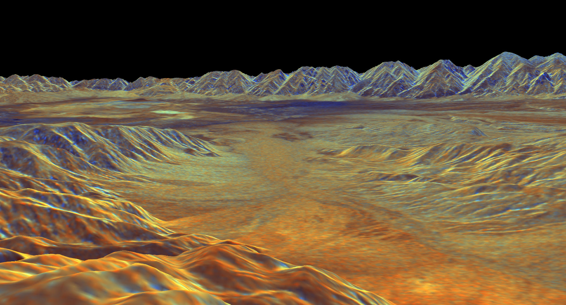
Saline Valley Radar Image


From NASA.
This is a three-dimensional perspective view of Saline Valley, about 30 km (19 miles) east of the town of Independence, California created by combining two spaceborne radar images using a technique known as interferometry. Visualizations like this one are helpful to scientists because they clarify the relationships of the different types of surfaces detected by the radar and the shapes of the topographic features such as mountains and valleys. The view is looking southwest across Saline Valley. The high peaks in the background are the Inyo Mountains, which rise more than 3,000 meters (10,000 feet) above the valley floor. The dark blue patch near the center of the image is an area of sand dunes. The brighter patches to the left of the dunes are the dry, salty lake beds of Saline Valley. The brown and orange areas are deposits of boulders, gravel and sand known as alluvial fans. The image was constructed by overlaying a color composite radar image on top of a digital elevation map. The radar image was taken by the Spaceborne Imaging Radar-C/X-band Synthetic Aperture Radar (SIR-C/X-SAR) on board the space shuttle Endeavour in October 1994. The digital elevation map was produced using radar interferometry, a process in which radar data are acquired on different passes of the space shuttle. The two data passes are compared to obtain elevation information. The elevation data were derived from a 1,500-km-long (930- mile) digital topographic map processed at JPL. Radar image data are draped over the topography to provide the color with the following assignments: red is L-band vertically transmitted, vertically received; green is C-band vertically transmitted, vetically received; and blue is the ratio of C- band vertically transmitted, vertically received to L-band vertically transmitted, vertically received. This image is centered near 36.8 degrees north latitude and 117.7 degrees west longitude. No vertical exaggeration factor has been applied to the data. SIR-C/X-SAR, a joint mission of the German, Italian, and the United States space agencies, is part of NASA's Mission to Planet Earth. Sensor: Space Shuttle/SIR-C/X-SAR.
This is a three-dimensional perspective view of Saline Valley, about 30 km (19 miles) east of the town of Independence, California created by combining two spaceborne radar images using a technique known as interferometry. Visualizations like this one are helpful to scientists because they clarify the relationships of the different types of surfaces detected by the radar and the shapes of the topographic features such as mountains and valleys. The view is looking southwest across Saline Valley. The high peaks in the background are the Inyo Mountains, which rise more than 3,000 meters (10,000 feet) above the valley floor. The dark blue patch near the center of the image is an area of sand dunes. The brighter patches to the left of the dunes are the dry, salty lake beds of Saline Valley. The brown and orange areas are deposits of boulders, gravel and sand known as alluvial fans. The image was constructed by overlaying a color composite radar image on top of a digital elevation map. The radar image was taken by the Spaceborne Imaging Radar-C/X-band Synthetic Aperture Radar (SIR-C/X-SAR) on board the space shuttle Endeavour in October 1994. The digital elevation map was produced using radar interferometry, a process in which radar data are acquired on different passes of the space shuttle. The two data passes are compared to obtain elevation information. The elevation data were derived from a 1,500-km-long (930- mile) digital topographic map processed at JPL. Radar image data are draped over the topography to provide the color with the following assignments: red is L-band vertically transmitted, vertically received; green is C-band vertically transmitted, vetically received; and blue is the ratio of C- band vertically transmitted, vertically received to L-band vertically transmitted, vertically received. This image is centered near 36.8 degrees north latitude and 117.7 degrees west longitude. No vertical exaggeration factor has been applied to the data. SIR-C/X-SAR, a joint mission of the German, Italian, and the United States space agencies, is part of NASA's Mission to Planet Earth. Sensor: Space Shuttle/SIR-C/X-SAR.
- Keyboard shortcuts:
Jump to top
RSS feed- Latest comments - Subscribe to the comment feeds of this photo
- ipernity © 2007-2024
- Help & Contact
|
Club news
|
About ipernity
|
History |
ipernity Club & Prices |
Guide of good conduct
Donate | Group guidelines | Privacy policy | Terms of use | Statutes | In memoria -
Facebook
Twitter
Sign-in to write a comment.