Stairs with Succulents
Circular Stairway
Falcate Orangetip
Red Shouldered Hawk
Hawk Pair
Noccalula Falls Double Rainbow
Crop Irrigation Circles
Spring Beauty
Yellow Star Grass
Bluets
Eastern Box Turtle
Eastern Phoebe
Two Vintage Buicks
!934 or 35 Buick
Hood Ornament
1933 Buick
Hood Ornament
Pasadena City Hall at Night
Pasadena City Hall
Ornate Doorway
Entrance to Gamblel House
Elevator Doors
Elevator Doors
Ornate Elevator Panels
Ornate Elevator Panels
Ornate Elevator Panels
Himmelman's Plume Moth
Sunrise
High Falls
High Falls
High Falls
High Falls
High Falls
Scenic Overlook
View from Bald Rock
Scenic Overlook
Scenic Overlook
Bald Rock
Bald Rock Boardwalk
Hood Ornament
1929 Graham-Paige
1929 Graham-Paige
1929 Graham-Paige
Civilian Consevation Corps Worker Statue
Bunker Tower Weathervane
Bunker Tower Weathervane
Bunker Tower Interior Stairwell
Bunker Tower Interior Stairwell
Bunker Tower
1930 Cadillac V16
1930 Cadillac V16 - Interior
1930 Cadillac V16 - Interior
Hood Ornament
1930 Cadillac V16
1930 Cadillac V16 - Wheels
1930 Cadillac V16
1930 Cadillac V16
1930 Cadillac V16 - Detail
Hood Ornament
1950-51 Ford Crestliner
1950-51 Ford Crestliner
Pre-War Buick
Pre-War Buick
Koi
Trapeze School
Goslings
Young Canada Goose Goslings
Canada Goose Gosling
Canada Goose Gosling
Canada Goose Goslings
Canada Goose Goslings
Canada Goose Goslings
Canada Goose Goslings
Canada Geese and Goslings
Canada Geese and Goslings
Warning - Leave Our Young'uns Alone!
Little River Falls
Lesser Goldfinch (Female)
Lesser Goldfinch (Male - Western Form)
Lesser Goldfinch Pair (Western Form)
Lesser Goldfinch (Male - Western Form)
Lesser Goldfinch (Male - Western Form)
Lesser Goldfinch (Female)
Lesser Goldfinch (Male - Western Form)
Lesser Goldfinch (Male - Western Form)
Clark Mountain
Cajon Pass at Swarthout Canyon Road
Mojave Desert
Cima Dome & Volcanic Field National Natural Landma…
Clark Mountain
Mojave Desert
Stairwell
Stairwell
Stairwell
Stairwell
Richard H. Chambers United States Court of Appeals
Pasadena City Hall at Night
Whooping Crane
Cardinal Flower
Cardinal Flower
Cardinal Flower
Cardinal Flower
Green Treefrog
Green Treefrog
Green Treefrog
Green Treefrog
Frog
Balloons at a Night Glow Show
Alabama Jubilee Hot Air Balloon Classic
1960 Chevrolet Nomad Station Wagon and Camping Tra…
Drone
Ornamentation Detail
Egrets at a Rookery
On a Nest
Baby Tending
Ergerts in a Rookery
Great Egret in a Rookery
Tiled Bench Back
Great Egrets on their Nest
Great Egret Pair
Baby Tending
American Coot
American Coot
Goldfinch (Male0
Northern Cardinal - Female with Pine Siskins
See also...
Keywords
Authorizations, license
-
Visible by: Everyone -
All rights reserved
-
216 visits
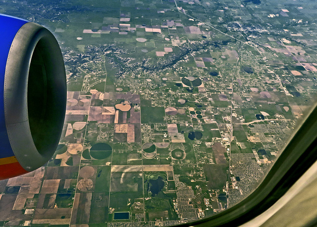
Aerial View - Randall County, Texas


At the lower right is Amarillo, Texas. The airport between the developments on the lower right is Tradewind Airport. The lake at the bottom center is in Southeast Park. The airport on the upper left in front of the engine is River Falls Airport. The lake above and to the right of the airport is Lake Tanglewood formed by the damming of Palo Duro Creek. The canyon top center is Timbercreek Canyon. The diagonal highway upper right is Interstate 27. (IMG_4867)
ROL/Photo, Eunice Perkins, Pam J have particularly liked this photo
- Keyboard shortcuts:
Jump to top
RSS feed- Latest comments - Subscribe to the comment feeds of this photo
- ipernity © 2007-2024
- Help & Contact
|
Club news
|
About ipernity
|
History |
ipernity Club & Prices |
Guide of good conduct
Donate | Group guidelines | Privacy policy | Terms of use | Statutes | In memoria -
Facebook
Twitter

I love to see the land from the air !
Congrats on Explore.
the same photo
Sign-in to write a comment.