Melbury Road W14
Mosaic
Remember
Waterfall
Earth would be less fair ...
Pond
Ribbons of Glass
Africa
Asia
The Americas
Europe
Cast Courts 2
Cast Courts 3
Cast Courts 1
Cast Courts 4
Ceramic Staircase, V&A Museum
Faux Shop in Kensington Church Walk
Bus shelter, Exhibition Road
Fragments
Cemetery Gates
Central Avenue
Brunel Family Tomb
E M Lander Ltd
Covered Angels
Tile & Ivy
Ninon
Tangled
In Memoriam
Mulready
Guardian
Foxes
Sievier Monument
Anglican Chapel
Iron & Wood
Conkers
Celestial Conkers Game
Graves & Gasometer
Angel of the Gasometer
Reformers Memorial 1
Mosaic 1
Reformers Memorial 2
Sainsbury's Pigeon
The Birds!
Blue & Orange
Mosaic 6
^^^^^
Mosaic 2
Orange & Blue
Color blocks
Mosaic 3
Mosaic 4
Mosaic 5
Victoria & George
Carmelite Monastery
Phiz Lived Here
Bevington Ladies
Spanish School
Temptation Alley
Lion 20p
Subterranean Loo
La Muralla 2
La Muralla 1
La Muralla 3
Dairy Produce
Banksy Painter
Sax Player
Colville School
Former Dairy
Trailer
Gate Cinema
Rotten Row
Ladbroke Square Gardens Gate
Coronet Cinema
Ladbroke Square Gardens W11
A Peak into the Garden
White Facades
The Feddens Live Here
Magpie
Kensington Park Gardens Sign W11
Serpentine Pavilion 2009 (Bunny ears)
Location
See also...
Keywords
Authorizations, license
-
Visible by: Everyone -
All rights reserved
-
242 visits
Cottages


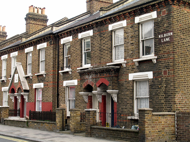
Queen's Park Estate, Kilburn Lane. I saw only one terrace block of these sweet little houses, but when I did my geotagging I could see that there are several streets of similar terraces, with variations in the gables and entrances.
Found this online at www.findaproperty.com/areaguidebook.aspx?edid=00&sale... : "The 1868 Artisans & Labourers Dwelling Act had given local authorities the power to clear slums, and this estate was built between 1870 and 1890 by the Artisans, Labourers and General Dwelling Company.
Their 2,000 brick terraced cottages have remained eternally popular and the company's aim reeks of Victorian paternalism: "To provide the labouring man with an increase of the comforts and convenience of life whilst providing full compensation for the capitalist".
Most of the homes are now privately owned and a strict conservation area is in force, with no double glazing and only Welsh slate allowed as a roofing material."
See where this picture was taken. [?]
- Keyboard shortcuts:
Jump to top
RSS feed- Latest comments - Subscribe to the comment feeds of this photo
- ipernity © 2007-2024
- Help & Contact
|
Club news
|
About ipernity
|
History |
ipernity Club & Prices |
Guide of good conduct
Donate | Group guidelines | Privacy policy | Terms of use | Statutes | In memoria -
Facebook
Twitter

Sign-in to write a comment.