Coastal
Photos taken at or near the coast.
Syncline in Lower Coal Measures sandstones: Swallo…
| |
|
Saundersfoot to Swallowtree Bay geological structures
Just south of the previous photo in Swallowtree Bay, Lower Coal Measures sandstones have been folded into a broad open syncline. The sandstones display cross-bedding and erosive channel bases.
Asymmetric anticline, Swallowtree Bay north
| |
|
Saundersfoot to Swallowtree Bay geological structures
An asymmetric anticline chevron fold developed in Lower Coal Measures sandstones just north of Swallowtree Bay near Saundersfoot. The fold has a vertical to slightly overturned northern limb. In the centre of the photo, minor thrusts disrupt the fold axis slightly, to accommodate the 'space problem'.
Ladies Cave Anticline: interior hinge zone
| |
|
Saundersfoot to Swallowtree Bay geological structures
The Ladies Cave Anticline is a well-known and much visited structure in Lower Coal Measures rocks, just south of Saundersfoot harbour.
This is a photo of the hinge zone in the 'cave', developed in the hinge zone of the fold. The weaker mudstones have 'flowed' up into the thickened fold hinge to form saddle structures. There are also small scale thrusts, marked by disruption of the brown ironstone layers.
The horizontal ridges on the underside of the steep northern limb probably indicate development of a fan cleavage, although it does not appear to be present on the opposite limb.
The main anticline photo is here:
Ladies Cave Anticline
| |
|
|
|
Saundersfoot to Swallowtree Bay geological structures
The Ladies Cave Anticline is a well-known and much visited structure in Lower Coal Measures rocks just south of Saundersfoot harbour.
This is a fine example of a chevron fold, often developed in alternating layers of stronger and weaker rocks. The fold is asymmetric; the axis dips steeply to the south (left). Accommodation structures as a result of the 'space problem' include thinning of the fold limbs in the weaker mudstones layers, 'flowing' up into the thickened fold hinge to form saddle structures.
There are also small scale thrusts in the hinge zone:
Earlier photos here (September 2010)
and here (February 1993)
Extentional faults detail: Saundersfoot south
| |
|
Saundersfoot to Swallowtree Bay geological structures
Detail of the faulted Lower Coal Measures rocks in the previous photo. I particularly liked the colours and textures of these rock and did not want to detract from these by including a scale object. The photo is about 1 metre top to bottom. The rocks are mostly grey mudstones with brown ironstone bands and nodules.
Extentional faults: Saundersfoot south
| |
|
Saundersfoot to Swallowtree Bay geological structures
Just south of Saundersfoot harbour, immediately adjacent to the previous photo, a set of extensional ('normal') faults with a small displacements cut Lower Coal Measures rocks: mostly mudstones with ironstone bands and nodules, with thin sandstone bands and laminae in the upper part.
The small thrust with a footwall syncline in the previous photo is just visible at the lower right.
The walking stick is 0.9 m long.
Detailed part of photo here:
Small thrust and footwall syncline
| |
|
Saundersfoot to Swallowtree Bay geological structures
Just south of Saundersfoot Harbour is a small thrust with a footwall syncline in Lower Coal Measures rocks. The anticline component of the fold couplet has been sheared out by the thrust.
The rocks are mainly grey mudstones with brown ironstone bands and nodules, with thin pale grey sandy lamine in the upper part and to the bottom right.
The walking stick is 0.9 m long.
Lattice Windows sea arches and Barafundle Bay
| |
|
|
|
Broad Haven (south) to Stackpole Head
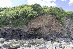
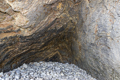
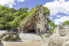
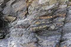
Viewed from just north of Stackpole Head, the narrow sea arches of 'Lattice Windows' form the headland at the south side of Barafundle Bay.
In contrast to the gentle southerly dip of the Carboniferous Limestone at Stackpole Head, fold structures have resulted in an increasingly steep northerly dip at Lattice Windows.
Barafundle Bay cloudscape from Stackpole Head
| |
|
|
|
Broad Haven (south) to Stackpole Head
Viewed from Stackpole Head, cloud-streets of cumulus set off the land and seascape looking towards Barafundle bay just left of centre. To the right, the light grey Carboniferous Limestone gives way to cliffs of 'Old Red Sandstone'.
Stackpole Head from Mowingword Point
| |
|
|
|
Broad Haven (south) to Stackpole Head
The cliffs of Stackpole Head consist of Carboniferous Limestone gently dipping south. There are sea caves and other solution features visible: the prominent bedding plane just below the cliff top displays palaeo-karst pot-hole-like features.
Caldey Island is on the centre skyline; Llanmadoc Hill and Rhosili Down on the Gower Peninsula can be seen in the far distance just above the headland.
Lichens and Viper's Bugloss on Mowingword Point
| |
|
|
|
Broad Haven (south) to Stackpole Head
Mowingword Point was very colourful on this beautiful summer's day, with the contrasting orange lichens and purple Viper's bugloss.
Mowingword Bay, Pinnacle Stack and Gun Cliff
| |
|
|
|
Broad Haven (south) to Stackpole Head
Viewed from Mowingword Point, Mowingword Bay, backed by Gun Cliff, is inaccessible except by sea or climbing down the cliffs (climbing equipment and experience needed). The prominent Pinnacle Stack is in the middle of the bay.
Church Rock just offshore from Broad Haven (S) is visible in the upper left.
The flat, Tertiary age '200-foot erosion surface' is well seen in this photo.
Sandy Pit doline panorama
| |
|
|
Broad Haven (south) to Stackpole Head
Immediately inland from Box Bay in the previous photo is the 'Sandy Pit' doline; a large karst solution hollow. There is a connection with the sea at the base, so marine erosion has probably contributed to the enlargement of the hollow.
The name 'Sandy Pit' possibly refers to a partial filling with post-glacial blown sand (subsequently largely exploited and excavated?)
This panoramic view shows the large size of the doline and consists of three landscape photos stitched together with Photoshop software.
Sandy Pit doline
| |
|
Broad Haven (south) to Stackpole Head
Immediately inland from Box Bay in the previous photo is the 'Sandy Pit' doline; a large karst solution hollow. There is a connection with the sea at the base, so marine erosion has probably contributed to the enlargement of the hollow.
The name 'Sandy Pit' possibly refers to a partial filling with post-glacial blown sand (subsequently largely exploited and excavated?)
The sea stack of Church Rock is visble in the distance to the left of centre.
Box Bay panorama
| |
|
|
|
Broad Haven (south) to Stackpole Head
Just east of Broad Haven and Saddle Point is Box Bay with well developed sea-caves at its eastern end. Can you see the climbers? The rocks are Carboniferous Limestone.
Box Bay is sometimes known as Sandy Pit Bay (after the doline just inland of the bay). Neither names are used on the Ordnance Survey maps.
The headlands of Mowingword and Stackpole Head are at the far right.
This is a panoramic view consisting of two landscape photos sticthed together using Photshop software. Also taken using a polarising filter. I'm pleased with how the clouds have turned out.
Box Bay with caves
| |
|
|
|
Broad Haven (south) to Stackpole Head
Just east of Broad Haven and Saddle Point is Box Bay with well developed sea-caves at its eastern end. Can you see the climbers? The rocks are Carboniferous Limestone.
Box Bay is sometimes known as Sandy Pit Bay (after the doline just inland of the bay). Neither names are used on the Ordnance Survey maps.
Church Rock from Saddle Point
| |
|
|
Broad Haven (south) to Stackpole Head
Church Rock sea stack, with its steeple-like point lies just off shore from Broad Haven. This is a view from Saddle Pooint at the eastern end of Broad Haven. The rocks here are Carboniferous Limestone.
There are two Broad Havens in Pembrokeshire. This is the southern one (the other is in the west in St Brides Bay).
Broad Haven (S) view west
| |
|
|
Broad Haven (south) to Stackpole Head
This is a view from the coast path at the eastern end of Broad Haven, looking west over the glorious beach. I liked the patterns of the waves and swash lines on the sand as the tide receded.
There are two Broad Havens in Pembrokeshire. This is the southern one (the other is in the west in St Brides Bay).
Jump to top
RSS feed- Latest items - Subscribe to the latest items added to this album
- ipernity © 2007-2024
- Help & Contact
|
Club news
|
About ipernity
|
History |
ipernity Club & Prices |
Guide of good conduct
Donate | Group guidelines | Privacy policy | Terms of use | Statutes | In memoria -
Facebook
Twitter


