Raasay: Ironstone processing works - southern end…
Raasay: view south along ironstone mine tramway
Raasay: view north along ironstone mine tramway
Raasay: No.2 Mine tramway winding house
Raasay: No.2 Mine tramway winding house interior
Raasay: No.2 Mine tramway view from winding house…
Raasay: Tramway junction
Raasay: No.1 Mine tramway viaduct piers
Raasay: No.1 Mine tramway viaduct - north pier
Raasay: No.1 Mine tramway viaduct and tributary bu…
Raasay: No.1 Ironstone Mine tramway with silver bi…
Raasay: No.1 Ironstone Mine adit entrance (intake)…
Raasay: No.1 Ironstone Mine adit entrance (intake)…
Raasay: No.1 Ironstone Mine adit entrance (intake)…
Raasay: Inverarish from mine tramway
Raasay: Churchton Bay and Ben Tianavaig on Skye
Raasay: Churchton Bay, Ferry, and Ben Tianavaig on…
Conglomerates at Gravel Bay
Conglomerate at Gravel Bay: close-up view 1
Conglomerate at Gravel Bay: close-up view 2
Moody sky over Freshwater West
Spray haze over Freshwater West
Freshwater West walkies
Raasay: Ironstone processing works - concrete gant…
Raasay: Ironstone processing works - incline and g…
Raasay: Ironstone processing works - calcining kil…
Raasay: Ironstone processing works - calcining kil…
Raasay: Ironstone processing works - ore hopper en…
Raasay: Ironstone processing works - ore hopper
Raasay: Ironstone processing works - ore hopper an…
Raasay: Ironstone processing works - ore hopper an…
Raasay: Ironstone processing works - old office bl…
Raasay: Ironstone processing works - old office bl…
Raasay: Ironstone processing works - old office bl…
Raasay: East Suisnish pier - W L Byers anchor 2
Raasay: East Suisnish pier - W L Byers anchor 1
Raasay: East Suisnish pier slipway 1
Raasay: East Suisnish pier
Raasay: Morning view over Churchton Bay to the Bla…
Raasay: Morning view over Churchton Bay to Skye
Raasay: Brae ruins 1
Raasay: Brae ruins 2
Raasay: Allt a' Bhràghad waterfall 2
Raasay: Allt a' Bhràghad waterfall 1
Raasay - Inver Bay panorama
1/125 • f/8.0 • 15.0 mm • ISO 100 •
Canon EOS 600D
EF-S15-85mm f/3.5-5.6 IS USM
Location
See also...
Keywords
Authorizations, license
-
Visible by: Everyone -
All rights reserved
-
84 visits
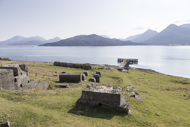
Raasay: Ironstone processing works - view down incline


Raasay Ironstone Mine and Processing Works
This is a view down the incline on the last section of the tramway which brought ore down from the mine adits to the processing plant.
The concrete blocks in the foreground are part of the crusher house foundations and just below centre are the gantry supports from which ore would have been transported from the crusher to be fed into the calcining kilns. The gantry and crusher house can be seen in the 1917 photo in the link below. East Suisnish pier and the mountains of Skye are in the background.
Background
The two adits of Raasay No.1 ironstone Mine were situated about 2.5 km north of East Suisnish pier and worked the Jurassic (Upper Lias) age siderite and chamosite ores from 1914 to 1920. The mine was owned and developed by William Baird & Co. who also built the terraces of houses in the village of Inverarish to house the mine workers, many of whom were German prisoners of war. A tramway and incline connected the mine to the processing works (crusher, calcining kilns, gantries, loading hoppers) at East Suisnish.
A second pair of mine adits (Raasay No.2 Ironstone Mine) just north of Inverarish were also opened up around the same time but never went into proper production due to geological difficulties (faulting).
There was also a small amount of opencast outcrop mining carried out near the No.1 Mine, again around the same time.
The works were dismantled by 1943 but the site is now a scheduled protected monument.
A view of the works in 1917 is here:
geoscenic.bgs.ac.uk/asset-bank/action/viewAsset?id=1343
Annemarie has particularly liked this photo
- Keyboard shortcuts:
Jump to top
RSS feed- Latest comments - Subscribe to the comment feeds of this photo
- ipernity © 2007-2024
- Help & Contact
|
Club news
|
About ipernity
|
History |
ipernity Club & Prices |
Guide of good conduct
Donate | Group guidelines | Privacy policy | Terms of use | Statutes | In memoria -
Facebook
Twitter

Sign-in to write a comment.