
Cima Presanella (3556 m)
Passo dello Stelvio (Stilfserjoch) - snake road
Rom valley - Valchava
Malojapass (Pass da Malögia) - 1812 m
Malojapass (Pass da Malögia) - 1812 m
Furkapass - Rhone glacier
Villaroger
Strada per il Rifugio Auronzo
Glaciar Perito Moreno
Rio Pinturas
Ruta 41 - Cerro Zeballos
Ruta 41 - Zeballos land
Lago Puelo
Lago Nahuel Huapi
Rio Limay - Anfiteatro
Lago Traful
Laguna Blanca - cloud watching
Ruta 40 - Laguna Nueva
Rio Grande
Paso de Uspallata (3832 m) - Chilean side
Cerro Aconcagua - 6961 m
Puente del Inca - 2744 m
Rio Mendoza - Transandine Railway
Rio San Juan - Ruta 12
Ischigualasto - El Submarino
Ischigualasto - El Submarino
Talampaya Gorge - El Tótem
Talampaya Gorge
Mirador Tres Cruces
Location
See also...
See more...Keywords
Authorizations, license
-
Visible by: Everyone -
All rights reserved
-
290 visits
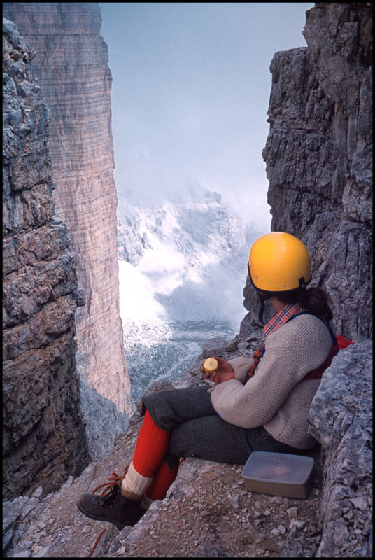
View from Rifugio Auronzo - 2330 m


Looking to the East the path leads in direction to the Zwölferkofel (Croda dei Toni, 3094 m) in the background. The "Tre Cime" to the left are not visible, therefore a PiP from an ascent to the Cima Grande (the middle one) in 1978. - scanned slides, Minolta X700
7. Strada per il Rifugio Auronzo, 2330 m, Italy - day 2
7. Strada per il Rifugio Auronzo, 2330 m, Italy - day 2
Jörg, Gabi Lombardo, Helena Ferreira, Guy Bacca (guybac) and 33 other people have particularly liked this photo
- Keyboard shortcuts:
Jump to top
RSS feed- Latest comments - Subscribe to the comment feeds of this photo
- ipernity © 2007-2024
- Help & Contact
|
Club news
|
About ipernity
|
History |
ipernity Club & Prices |
Guide of good conduct
Donate | Group guidelines | Privacy policy | Terms of use | Statutes | In memoria -
Facebook
Twitter
Sign-in to write a comment.