Shooting information for this photo
← Back to the photo page
Want to know more about EXIF?
Check wikipedia page about Exchangeable image file format (EXIF)
Check wikipedia page about Exchangeable image file format (EXIF)
Some of EXIF data are only available in English.
| Resolution: | 300 x 300 dpi |
|---|---|
| Dimension: | 1920 x 1276 pixels |
| Created on: | 2007:05:19 16:31:11+01:00 |
| Modified on: | 2007:05:19 16:31:11 |
| Software: | RoboGEO v5.0.19 |
| Copyright: | Andrew Luyten 2004 |
| Color Mode | RGB |
| Color Space | sRGB |
| Components Configuration | Y, Cb, Cr, - |
| Compression | JPEG (old-style) |
| Derived From Document ID | uuid:DB1E0B791A06DC118D2BFB5F0 366777D |
| Derived From Instance ID | uuid:419542CD1D06DC118D2BFB5F0 366777D |
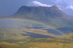
| Description | In typical NW Scotland fashion this short sharp shower made for some wonderful mountain atmosphere on Cul Mor (849m), seen here from Stac Pollaidh.. |
| Device Mfg Desc | IEC http://www.iec.ch |
| Device Model Desc | IEC 61966-2.1 Default RGB colour space - sRGB |
| Exif Version | 0221 |
| Flashpix Version | 0100 |
| Format | image/jpeg |
| ICC Profile Name | sRGB IEC61966-2.1 |
| Image Description | In typical NW Scotland fashion this short sharp shower made for some wonderful mountain atmosphere on Cul Mor (849m), seen here from Stac Pollaidh.. |
| Image Size | 1920x1276 |
| Interoperability Index | R98 - DCF basic file (sRGB) |
| Interoperability Version | 0100 |
| Marked | True |
| Metadata Date | 2007:05:19 16:48:24+01:00 |
| Native Digest | 256,257,258,259,262,274,277,28 4,530,531,282,283,296,301,318, 319,529,532,306,270,271,272,30 5,315,33432;99A48887C0A4A19B8F E194E239719077 |
| Resolution Unit | inches |
| Rights | Andrew Luyten 2004 |
| Subject | Scotland, CulMor |
| Thumbnail Offset | 714 |
| Title | Shower on Cul Mor |
| XMP Toolkit | 3.1.2-113 |
GPS Information |
|
| GPS Latitude | 58 deg 2' 38.78" N |
| GPS Latitude Ref | North |
| GPS Longitude | 5 deg 12' 20.58" W |
| GPS Longitude Ref | West |
| GPS Position | 58 deg 2' 38.78" N, 5 deg 12' 20.58" W |
| GPS Version ID | 2.2.0.0 |
Jump to top
- ipernity © 2007-2024
- Help & Contact
|
Club news
|
About ipernity
|
History |
ipernity Club & Prices |
Guide of good conduct
Donate | Group guidelines | Privacy policy | Terms of use | Statutes | In memoria -
Facebook
Twitter
