Manitoba - Military
23 May 2015
1 comment
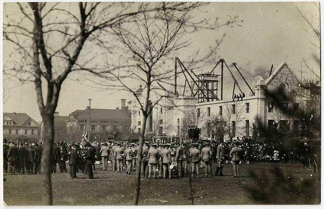
WP1905 WPG - (CONSTRUCTION OF CENTRAL POWER HOUSE)
Unposted.
Publisher / Photographer: Unidentified
An interesting image showing the Central Power House (on Memorial Blvd.) under construction - dating this photograph to 1915, when it was built. This is likely a military assembly of some kind. The group of men in grey suits are uniformed members of a marching band, instruments in-hand.
The Vaughan Street Jail is in the background. The tower-like scaffolding behind the powerhouse has a sign reading "National Construction'.
02 Jun 2015
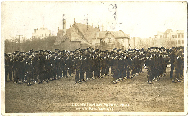
WP1912 WPG - DECORATION DAY PARADE WINNIPEG MAY 11, 1913
Posted: May 17, 1913 from Winnipeg to Elizabethtown, PA
Publisher / Photographer: Unidentified
It is too bad that this image has postal inking on it. It is the only postcard image I have seen of the original (seemingly-wooden) All Saints Church at the intersection of Broadway & Osborne. At this time, Osborne Street ended at Broadway and this church stood at the north side of the intersection. In the early 20's the City decided to extend Osborne through to Portage Avenue - which precipitated the demolition of this church and the construction of the new (current) stone one somewhat to the west of the original site.
I assume that the large building in the back left is likely the McDonagh and Shea Brewery on Colony Street.
29 Nov 2016
2 comments
WP2160 WPG - [TENTS ON FIELD SOUTH OF MINTO ARMOURY]
POSTCARD
Date: Not evident. Not Posted.
Publisher / Photographer: Unidentified
Notation: This is a tented camp in the field just south of Minto Armouries (969 St Matthews Ave, Winnipeg). The field is currently a parking lot and athletic field. The Minto Armouries were opened in 1915 and, based on the Cyko stamp box on the reverse, this photo was taken prior to 1920. I am not certain, but I believe I read that during WWI troops camped outside the Armouries prior to going to Camp Hughes.
The feature of this card that most caught my attention, however, is the cylindrical tower on the skyline.
This large gas storage tank sometimes referred to as the "Gasometer" was constructed in 1910 (as reported on page 10 of the September 19, 1910 edition of the Free Press). Located in the Wolseley area, I have heard that the tank held a reserve of gas which was manufactured by the Winnipeg Electric Company. It was dismantled in 1959 (as reported on page 3 of the April 15, 1959 edition of the Free Press).
Over the years, I have read many reports and heard many opinions as to the exact location of the tank. Thanks to Christy C. at the Winnipeg Public Library, I now have a definitive photograph to refer to. (See below.) The tank itself seems to have stood on the south side of Palmerston Avenue, roughly between Lipton Street on the west and the Lipton/Ruby back lane on the east.
This image was found at: www.mhs.mb.ca/docs/organization/stmarysacademy.shtml and entitled “Aerial view St. Mary’s Academy and surrounding Crescentwood neighborhood, 1923” Source: Archives of Manitoba, FA23/1-72, C10, Box 15, 1960-2.
The gas tank appears in another postcard in my collection: WP2002 WPG - ASSINABOINE RIVER ICE GOING OUT
Jump to top
RSS feed- Latest items - Subscribe to the latest items added to this album
- ipernity © 2007-2024
- Help & Contact
|
Club news
|
About ipernity
|
History |
ipernity Club & Prices |
Guide of good conduct
Donate | Group guidelines | Privacy policy | Terms of use | Statutes | In memoria -
Facebook
Twitter


![WP2160 WPG - [TENTS ON FIELD SOUTH OF MINTO ARMOURY] WP2160 WPG - [TENTS ON FIELD SOUTH OF MINTO ARMOURY]](http://cdn.ipernity.com/200/58/60/43915860.f7df19cd.640.jpg?r2)