
Charles Darwin's study
Panels of an Assyrian Writing Board in the Metropo…
Alles Gute im neuen Jahr - All the best for the ne…
Öffentlicher Bücherschrank (BOKX)
Bullock (Ox) wagons in Buenos Aires
Bronze Statues of Girls Chasing Partridges in the…
Bronze Statues of Girls Chasing Partridges in the…
Bronze Statues of Girls Chasing Partridges in the…
Bronze Statues of Girls Chasing Partridges in the…
Bronze Statues of Girls Chasing Partridges in the…
Bronze Statues of Girls Chasing Partridges in the…
Bronze Statues of Girls Chasing Partridges in the…
Bronze Statues of Girls Chasing Partridges in the…
Bronze Statues of Girls Chasing Partridges in the…
Bronze Statues of Girls Chasing Partridges in the…
Bronze Statues of Girls Chasing Partridges in the…
Bronze Statues of Girls Chasing Partridges in the…
Bronze Statues of Girls Chasing Partridges in the…
Bronze Statues of Girls Chasing Partridges in the…
Bronze Statues of Girls Chasing Partridges in the…
Bronze Statues of Girls Chasing Partridges in the…
St. Elmo's Fire
Bahia, Brazil
McCord United Church
vigilant prairie dog 2
vigilant prairie dog
Pella Sietas Werft
Estesperrwerk in Cranz
Am Airbuswerk in Hamburg-Finkenwerder
Join us ...
See also...
Keywords
Authorizations, license
-
Visible by: Everyone -
All rights reserved
-
10 visits
Photo by Dinesh
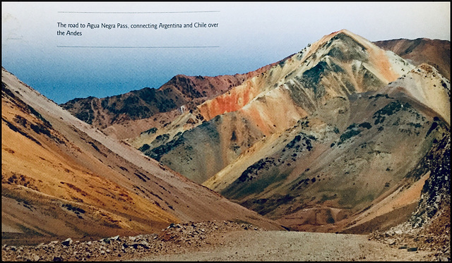

The road to Qgua Negra Pass, connecting Argentina and Chile over the Andes
en.wikipedia.org/wiki/Agua_Negra_Pass
en.wikipedia.org/wiki/Agua_Negra_Pass
- Keyboard shortcuts:
Jump to top
RSS feed- Latest comments - Subscribe to the comment feeds of this photo
- ipernity © 2007-2024
- Help & Contact
|
Club news
|
About ipernity
|
History |
ipernity Club & Prices |
Guide of good conduct
Donate | Group guidelines | Privacy policy | Terms of use | Statutes | In memoria -
Facebook
Twitter
Because of its altitude, the current pass is subject to frequent closures due to bad weather and this route also poses challenges to drivers even in good conditions. Clearly, the construction of a new route is important to both countries and the new tunnel connection will make a major improvement in transport. The highway project consists of two parallel tunnels that will carry two traffic lanes. The tunnels run for a distance of 13.9km and have a maximum width of 11m but because the tunnels run through high mountains, the maximum incline has been limited to 4%. The Agua Negra Tunnel will be designed for a maximum speed of 100km/h, a maximum cant of 2.5% and with a radius curvature of 1,500m, as well as a maximum longitudinal incline of 3.37%.
www.worldhighways.com/wh10/wh8/feature/agua-negra-tunnel-between-chile-and-argentina
Sign-in to write a comment.