

Leon_Vienna's photos with the keyword: Wasser
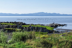
Saint Lawrence, Migrating South - 2007 (PiP)
| 23 Feb 2022 |
|
|
|

Saint Lawrence, Saint-Roch-des-Aulnaies, 80°x20°-1…
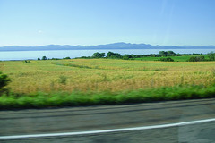
Saint Lawrence, Way down to Rivere du Loup - 2007…
| 19 Feb 2022 |
|
|
|
Travelling down the Lawrence Valley, fertile and well cared for lands are all around.
The Laurentian mountains form the background scenery. They are among the oldest geological formations on earth.
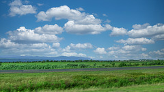
Saint Lawrence, On the Road again - 2007 (2xPiP)
| 18 Feb 2022 |
|
|
|
Travelling down the Lawrence Valley, fertile and well cared for lands are all around. Looking closer, the north end of Île d’Orléans is visible, a more middle part in PiP1.
The Laurentian mountains form the background scenery. They are among the oldest geological formations on earth.
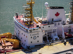
Quebec, Pierre Radisson - 2007
| 17 Jan 2022 |
|
|
|
Pierre-Esprit Radisson (frz)
Pierre-Esprit Radisson (eng)
Pierre-Esprit Radisson (deu)
Casseur de glaces
Icebreaker
Eisbrecher
Aus de.wikipedia:
Die „Pierre Radisson“ erlangte im Jahr 2015 Bekanntheit, als sie den russischen Helikopterpiloten Sergey Ananov rettete. Ananov hatte versucht, die Welt im Helikopter zu umkreisen und stürzte bei diesem Unterfangen zwischen Grönland und der kanadischen Baffininsel ab. Ananov überlebte den Crash und wurde schließlich von der „Pierre Radisson“ gerettet.
Le "Pierre Radisson" s'est fait connaître en 2015 lorsqu'il a sauvé le pilote d'hélicoptère russe Sergey Ananov. Ananov avait tenté de faire le tour du monde en hélicoptère et s'était écrasé lors de cette entreprise entre le Groenland et l'île de Baffin au Canada. Ananov a survécu au crash et a finalement été sauvé par le "Pierre Radisson".
The "Pierre Radisson" gained notoriety in 2015 when it rescued the Russian helicopter pilot Sergey Ananov. Ananov had attempted to circumnavigate the globe in a helicopter and crashed during this endeavour between Greenland and Canada's Baffin Island. Ananov survived the crash and was eventually rescued by the "Pierre Radisson".
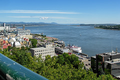
Quebec, Looking down St. Laurence River - 2007 (2…
| 16 Jan 2022 |
|
|
|
View from the terraces at Chateau Frontenac down the St. Lawrence River. Those who have read my Wikipedia references know that "Quebec" means "where the river narrows". After Quebec City, the river widens again, but firstly becomes divided into two arms by the Ile de Orleans. Behind of it, the estuary of the St. Lawrence opens, which becomes up to 60km wide.
On the right edge the east (or south?) bank is visible with some houses of neighbouring city of Levis. From the left edge to the center of the picture, Laurentian Mountains, one of the oldest mountains in the world can be seen.
Ottawa, "View on the River"-Pano - 2007
| 08 Jan 2022 |
|
|
|
Months ago already I was thinking about how to present panoramic shots here on Ipernity. One possibility for me could be a screenshot video. I have only little knowledge about that video thing and because the result was not really convincing for me, I asked Claus-Peter, Markus and Uwe for their opinion. Since none of them shouted "yarks, leave your hands of it!!" I will show you after weeks of silence what I managed to do back then. I am still not satisfied, but my time for such things is very limited and I doubt that I ever will handle moving pictures any better, than here.
An almost 180° panoramic view along and across Ottawa river can be seen here, rather little of Ottawa City ('cause it's in our back), but a lot of Gatineau and a very little of huge Quebec province.
Translated with www.deepl.com/Translator (free version)
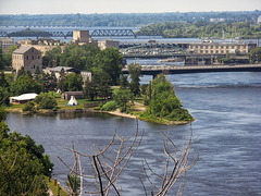
Ottawa, Victoria Island - 2007
| 15 Nov 2021 |
|
|
|
Zu sehen sind vier von sechs Brücken, die den Ottawa River hier überspannen und Ontario mit der Provinz Quebec und Ottawa City mit seiner Zwillingsstadt Gatineau verbinden. Was in der Mitte wie eine fünfte Brücke aussieht, ist ein Damm, der den Fluss aufstaut, die Chaudière Fälle fast trocken legt und das Wasser zwei Kraftwerken zuführt.
Mehr über Victoria Island hier:
en.wikipedia.org/w/index.php?title=Victoria_Island_(Ottawa_River)&oldid=1036128401
Jump to top
RSS feed- Leon_Vienna's latest photos with "Wasser" - Photos
- ipernity © 2007-2026
- Help & Contact
|
Club news
|
About ipernity
|
History |
ipernity Club & Prices |
Guide of good conduct
Donate | Group guidelines | Privacy policy | Terms of use | Statutes | In memoria -
Facebook
X
