


Rocks, minerals and fossils

Folder: Geology and Earth Science
General photos of rocks, minerals, fossils, rock faces, etc.
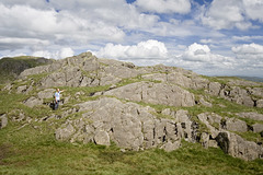
Pavey Ark - very strange rocks
| |
|
These rocks are on Pavey Ark in the Lake District National Park, England, about 350 m ENE of the summit cairn. The grid reference of the camera location is NY 28768 08076, close by the North Rake footpath.
The rocks in this photo belong to the uppermost part of the Dungeon Ghyll Member in the Borrowdale Volcanic Group (Ordovician). They are coarse, crudely bedded volcaniclastic pebbly sandstones, probably resulting from ash-fall into water, with accompanying andesite lava spatter; the whole lot subsequently disrupted by slumping and mass movement (Millward et al, 2000).
The 'strangeness' is due to the presence of curious, concentric ring-like structures which appear to be secondary (i.e. later) concretions - expanding growths of secondary minerals (epidote?) to form spheroidal masses, which are easily discernible in the main photo (zoom in). The origin of these structures is unclear, and they do not seem to be documented from anywhere else in the district, although I have seen similar but less well developed structures on Side Pike in Great Langdale and near Levers Water in the Coniston Fells.
Reference:
Millward, D. et al. 2000. Geology of the Ambleside district, British Geological Survey Memoir for 1:50000 Geological Sheet 38, London HMSO.
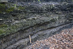
Chavery Coal and roof strata, Duckmanton Railway C…
| |
|
|
This is the Duckmanton Railway Cutting Site of Special Scientific Interest, near Chesterfield, north-east Derbyshire. In the lower part of the section is the Chavery Coal, overlain by shaly mudstones containing non-marine bivalves and ostracods. This exposure of the Chavery coal was worked (illegally) by desperate miners during the 1984-85 miners' strike. (Chris Darmon, pers. comm.)
The railway cutting is a site of international geological importance, as it contains the stratotype section for the Anthracoceras vanderbeckei (Clay Cross) marine band which is the boundary between the Langsettian and Duckmantian Stages of the Carboniferous, informally the junction between the Lower and Middle Coal Measures.
The site is managed by the Derbyshire Wildlife Trust and is accessible by permit only.
www.derbyshirewildlifetrust.org.uk/reserves/duckmanton-railway-cutting
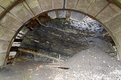
Chavery Coal and roof measures, Duckmanton Railway…
| |
|
A view of the strata exposed in the steel arch shelter in the Duckmanton Railway Cutting, near Chesterfield, north east Derbyshire. The Chavery Coal is visible in the lower left. This is overlain by shaly mudstones containing ironstone bands and nodules. Fossils in the roof mudstones include non-marine bivalves ( Anthracosia ) and and ostracods ( Geisina ).
The railway cutting is a site of international geological importance, as it contains the stratotype section for the Anthracoceras vanderbeckei (Clay Cross) marine band which is the boundary between the Langsettian and Duckmantian Stages of the Carboniferous, informally the junction between the Lower and Middle Coal Measures.
The site is managed by the Derbyshire Wildlife Trust and is accessible by permit only.
www.derbyshirewildlifetrust.org.uk/reserves/duckmanton-railway-cutting
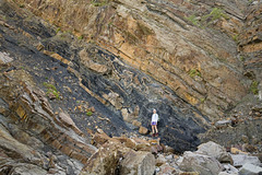
Maer Cliff incompetent deformation - detail
| |
|
Chaotically deformed and disrupted thin sandstone bands within a horizon of highly sheared dark grey shale - behind the person - in the Bude Formation (upper Carboniferous) at Maer Cliff between Northcott Mouth and Bude, north Cornwall.
As a result of compression as part of the Variscan earth movements at the end of the Carboniferous, the weak (incompetent) shale has been strongly deformed, compared with the strong (competent) sandstone beds above and below the shale. Thin sandstone beds have been caught up in the deformed shale and have undergone severe folding and fracturing. The brown sandstone beds in the upper part of the cliff have moved to the left (north) relative to the lower sandstone beds, with the planes of thrusting and shearing being concentrated in the dark shale.
This deformation probably represents substantial slippage along the bedding planes of the weak shales to accommodate the 'space' problem in the series of chevron folds which characterise this area.
Vertical bedding slab at Northcott Mouth, Cornwall…
| |
|
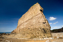
This vertical slab of sandstone is at Northcott Mouth, near Bude, north Cornwall. See geotag for exact location.
This is part of the Bude Formation (upper Carboniferous) - deltaic and some turbidite sandstones interbedded with shales. The sandstones are relatively thick, compared with the underlying Crackington Formation, and as a result, more competent. The response to the Variscan earth movements at the end of the Carboniferous was to form more open, mostly upright or slightly asymmetric angular folds, compared with the cascades of tight recumbent folds which characterise the Crackington Formation a few kilometres to the south.
This slab is the part of the vertical northern limb of an asymmetric anticline, and the view is of the underside of he bedding. There are sole structures - mostly trains of ripples/scours - on this surface, proving that it is the base of the bed.
I would guess that the local rock climbing fraternity have given this slab a name, so if anyone knows it please let me know. Thanks!
Crackington Haven sole structures 2
| |
|
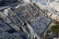
Another view of the sole structures on the inverted (upside-down) base of a turbidite sandstone slab in the Crackington Formation on the south side of the beach at its type locality, Crackington Haven, north Cornwall. The palaeo-current direction in this photo was from lower left to upper right.
The scale can be deduced from the limpets - the largest is about 4 cm across.
A full explanation of the structures and what they can tell us can be found here:
www.ipernity.com/doc/earthwatcher/39023846
Crackington Haven sole structures 1
| |
|
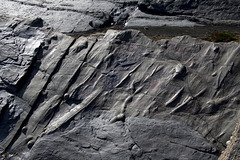
These elongated ridges are seen on the inverted bedding surface of a turbidite sandstone bed (Crackington Formation, upper Carboniferous) on the south side of Crackington Haven, north Cornwall. The scale can be deduced from the limpets - the largest is about 4 cm across.
The ridges are casts of sandstone infill into what was originally a hollow groove in the underlying sediment. The grooves were formed at the time of sediment deposition by fast-flowing water making small erosion scours around irregularities on the Carboniferous sea bed. Sometimes the current flow was sufficiently powerful to drag along pebbles and small boulders, which created long linear grooves.
Here, the rocks have been turned almost completely upside-down by intense folding at the end of the Carboniferous, so the grooves now appear as ridges. These sedimentary structures are generally known as 'sole structures' and are valuable as 'way-up' indicators - we can tell whether the rocks are the right way up or have been inverted, as is the case here.
Also in this example, the scours are asymmetrical - deeper at the upstream end (lower right) and shallowing off at the downstream end (upper left), so they also provide evidence for the water current direction at the time of deposition. So in this case, the water flowed from lower right to upper left. But the rocks have been inverted by folding, so.....
Here, the rocks are dipping (sloping) to the north (right) at about 30°, having been completely overturned by the folding. To restore this slab into its pre-folding position we need to imagine it 'flipped over', by rotating it through approx. 150° in a clockwise sense, like closing the left-hand side of an open book.
Once we do this, the sole structure ridges on the upper surface of the slab become protrusions on the underside of the slab, with the asymmetric deeper upstream side to the left (south) and the shallower downstream side to the right (north). Therefore, the original current direction which transported the sediment of the Crackington Formation was from south to north: the source of the sediment lay to the south, and was transported northwards by the water currents.
NB: The information board by the public toilets at Crackington Haven is excellent, except for where it states that the Crackington Formation sediment derivation was from the north. Sorry, but they've got that bit wrong! The evidence is there on the beach for all to see.
Heather and rock
| |
|
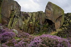
Evening light catches the heather and the Cioch Block (right) at the old millstone quarry at the south east end of the Burbage Valley in the Peak District National Park near Sheffield.
This quarry is one of several in the locality which worked the Chatsworth Grit (or Rivelin Grit) for millstones and grindstones.
Stanage End Slab
| |
|
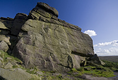
The first main climbers' crag at Stanage End, probably an old quarry face. I'm sure it has a name. Anyone care to help out please?
Stanage Edge is comprised of Rivelin Grit (aka Chatsworth Grit), Namurian age, Upper Carboniferous. The coarse-grained gritstone was deposited in a series of delta distributary channels. The gritstone is normally strongly cross-bedded, as seen here.
I Love Flamborough
| |
|
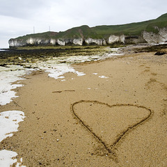
The title says it all really....
Selwicks, Bay, Flamborough, East Yorkshire.
Note the capping of brown glacial till ('boulder clay') overlying the Chalk cliffs.
Molk Hole arch
| |
|
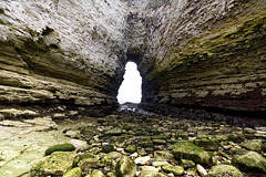
Molk Hole is an intriguing irregularly-shaped inlet at the north end of Selwicks Bay, Flamborough. A fascinating area of Chalk cliffs, sea caves and arches, hollowed out along fault and fracture zones in part of the Howardian Hills-Flamborough Fault Belt.
A lovely place to explore at low tide.
Molk Hole 2
| |
|
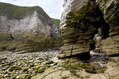
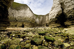
Molk Hole is an intriguing irregularly-shaped inlet at the north end of Selwicks Bay, Flamborough. A fascinating area of Chalk cliffs, sea caves and arches, hollowed out along fault and fracture zones in part of the Howardian Hills-Flamborough Fault Belt.
A lovely place to explore at low tide.
Molk Hole 1
| |
|
|
Molk Hole is an intriguing irregularly-shaped inlet at the north end of Selwicks Bay, Flamborough. A fascinating area of Chalk cliffs, sea caves and arches, hollowed out along fault and fracture zones in part of the Howardian Hills-Flamborough Fault Belt.
A lovely place to explore at low tide.
Selwicks Bay faults
| |
|
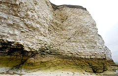
Small faults cutting the Chalk at the north end of Selwicks Bay, Flamborough. The Chalk here is disturbed by the Howardian Hills-Flamborough fault belt, although this particular bit is not particularly deformed.
I also liked the colours and textures in the lower part of the cliff.
Selwicks Bay panorama
| |
|
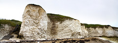
Disturbed Chalk in the Howardian Hills-Flamborough Fault belt at West Cliff, Selwicks Bay, Flamborough, East Yorkshire.
A panoramic stitching of 4 photos, using Canon's Photostitch software.
Unstable Cliffs at Old Quay, Filey, North Yorkshir…
| |
|
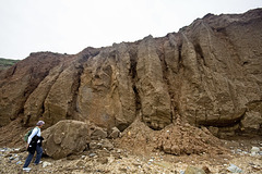
Cliffs comprised of Devensian glacial till ('boulder clay) just south of Old Quay Rocks at near Filey Brigg, North Yorkshire.
The cliffs display mud-flows and gulleying, toppling failures (note fallen block next to Jan) as well as rotational slides.
Old Quay Rocks and Filey Brigg
| |
|
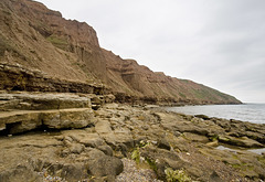
Uploaded for the Guesswhere UK group.
These splendid cliffs are at Old Quay Rocks, Filey, looking eastwards towards Filey Brigg in the distance. The foreground rocks are the Coralline Oolite Formation (Upper Jurassic) overlain by thick glacial till - 'boulder clay' (Devensian).
Disturbed Chalk stack at Selwicks Bay, Flamborough…
| |
|
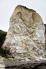
This Chalk (Upper Cretaceous, Burnham Formation) stack at West Cliff, Selwicks Bay, Flamborough, East Yorkshire, is severely deformed by folding and thrusting as part of the east-west trending Howardian Hills-Flamborough Fault belt, which is magnificently exposed in the northern part of Selwicks Bay.
Structures such as this are rare in the Chalk of northern England, but in the Flamborough area, these E-W belts of disturbed Chalk have been recognised since 1829 during the early years of geological surveying in the UK.
A comprehensive account of the structural geology of the Flamborough area is given in:
Starmer, I.C. 1995. Deformation of the Upper Cretaceous Chalk at Selwicks Bay, Flamborough Head, Yorkshire: its significance in the structural evolution of north-east England and the North Sea Basin. Proceedings of the Yorkshire Geological Society, vol 50, part 3, pp 213-228.
Includes superb maps, sections and 3D block diagrams - well worth a read.
Jump to top
RSS feed- Latest items - Subscribe to the latest items added to this album
- ipernity © 2007-2026
- Help & Contact
|
Club news
|
About ipernity
|
History |
ipernity Club & Prices |
Guide of good conduct
Donate | Group guidelines | Privacy policy | Terms of use | Statutes | In memoria -
Facebook
X
