Glacial and periglacial structures and landforms
Folder: Geology and Earth Science
Photos illustrating landforms resulting from glacial and periglacial processes.
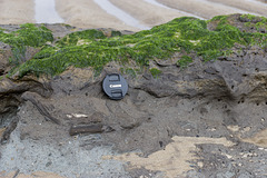
Spurn Neck close-up of peaty layer
| |
|
|
A visit to Spurn Point 2
Spurn Neck eastern low tide zone. A close-up view of the pale grey 'Basement Till', a lodgement till ('boulder clay') deposited by ice in the Wolstonian glaciation, 250,000 - 150,000 years ago. This is overlain by the chocolate-brown, rather peaty clay and silt, visible in the centre of the photo. This deposit, with its embeded woody plant remains represents the Ipswichian warm interglacial stage which lasted until 110,000 years ago. This in turn is overlain by the Skipsea Till, (not seen here) deposited by the last glaciation event, which finally ended in this area about 11,500 years ago.
The lens cap is 72 mm in diameter.
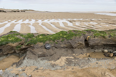
Spurn Neck Basement Till and peaty layer
| |
|
|
A visit to Spurn Point 1
Low tide at Spurn Neck exposes the pale grey 'Basement Till', a lodgement till ('boulder clay') deposited by ice in the Wolstonian glaciation, 250,000 - 150,000 years ago. This is overlain by the chocolate-brown, rather peaty clay and silt, visible in the centre of the photo. This deposit, with its embeded woody plant remains represents the Ipswichian warm interglacial stage which lasted until 110,000 years ago. This in turn is overlain by the Skipsea Till, which comprises the low cliffs seen in the far distance, deposited by the last glaciation event, which finally ended in this area about 11,500 years ago.
The lens cap is 72 mm in diameter.
St Brides Haven solifluction deposit
| |
|
Solifluction deposit ('head') on the east side of St Brides Haven, Pembrokeshire. This consists of a jumbled mass of angular sandstone fragments derived from the underlying Old Red Sandstone and was formed by freeze-thaw action at the end of the last glacial period. These deposits would have been part of the permafrost layer which partially melted during the summer months, refreezing again during the winter.
Small-scale fold-like features near the base are cryoturbation structures, probably due to ice-wedging as the refreezing permafrost layer expanded upwards.
The walking stick is about 0.9 m long.
Marros west - cryogenic anticline and solifluction…
| |
|
Marros Sands to Amroth
Just east of Amroth, we cross the county boundary into Carmarthenshire. The fine beach of Marros Sands, some 4 km east of Amroth is relatively isolated between Telpyn Point and Ragwen Point. There is no road access; the only way to get here is along the coastal paths, along the beach at lowest tide, or by boat.
At the western end of Marros Sands the Teague's Wood valley cuts down to the beach. The valley centre is filled with solifluction deposits ('Head') formed by freeze-thaw cycles of permafrost melting and refreezing at the end of the last glacial period (Devensian).
This is a closer view of the cryogenic anticlinal fold in the shales of the Bishopton Mudstone Formation The fold is probably due to valley bulging during melting of the permafrost. The fold is quite superficial and probably does not extend more than a few metres into the sub-surface.
Overlying the shales are angular, frost-shattered, shale fragments, possibly with some upward pointing ice-wedging structures. This is overlain in turn by a paler, angular, solifluction 'Head' and modern river alluvium, mostly sand with rounded pebbles and cobbles. See notes.
The walking stick is approx. 90 cm long
Marros west - cryogenic anticline and solifluction…
| |
|
Marros Sands to Amroth
Just east of Amroth, we cross the county boundary into Carmarthenshire. The fine beach of Marros Sands, some 4 km east of Amroth is relatively isolated between Telpyn Point and Ragwen Point. There is no road access; the only way to get here is along the coastal paths, along the beach at lowest tide, or by boat.
At the western end of Marros Sands the Teague's Wood valley cuts down to the beach. The valley centre is filled with solifluction deposits ('Head') formed by freeze-thaw cycles of permafrost melting and refreezing at the end of the last glacial period (Devensian).
In the centre is a cryogenic anticlinal fold in the shales of the Bishopton Mudstone Formation The fold is probably due to valley bulging during melting of the permafrost. The fold is quite superficial and probably does not extend more than a few metres into the sub-surface.
Overlying the shales are angular, frost-shattered, shale fragments, possibly with some upward pointing ice-wedging structures. This is overlain in turn by a paler, angular, solifluction 'Head' and modern river alluvium, mostly sand with rounded pebbles and cobbles. See notes.
The walking stick is approx. 90 cm long.
Marros west - Teague's Wood and drift-filled valle…
| |
|
|
Marros Sands to Amroth
Just east of Amroth, we cross the county boundary into Carmarthenshire. The fine beach of Marros Sands, some 4 km east of Amroth is relatively isolated between Telpyn Point and Ragwen Point. There is no road access; the only way to get here is along the coastal paths, along the beach at lowest tide, or by boat.
At the western end of Marros Sands the Teague's Wood valley cuts down to the beach. The valley centre is filled with solifluction deposits ('Head') formed by freeze-thaw cycles of permafrost melting and refreezing at the end of the last glacial period (Devensian).
Stac Pollaidh west end
| |
|
This is a view of western end of the Stac Pollaidh ridge. If anyone knows the name of the pinnacle on the right, please say.
Gathering Hill from the Snake Pass summit, Derbysh…
| |
|
Gathering Hill is a spur on the southern edge of Shelf Moor, itself part of the extensive Bleaklow massif in the Dark Peak.
This is a northward view from the A57 Snake Pass at its highest point at 512 m elevation. This is also where the Pennine Way crosses the road.
Canisp from Creag Dharaich
| |
|
A fine evening looking over the chaotic knock-and-lochan landscape of the Lewisian Gneiss foreland towards Canisp one of the relict Torridonian Sandstone mountains. The red Torridonian Sandstone of Canisp lies unconformably on the Lewisian Gneiss and is itself unconformably overlain by the pale grey Cambrian Basal Quartzite just visible on the summit.
A south-easterly view from the Creag Dharaich viewpoint near Lochinver, Sutherland, Scotland.
Suilven from Creag Dharaich
| |
|
|
A fine evening looking over the chaotic 'knock and lochan' landscape of the Lewisian Gneiss foreland towards Suilven, one of the relict Torridonian Sandstone mountains. The red Torridonian Sandstone lies unconformably on the Lewisian Gneiss.
A south-easterly view from the Creag Dharaich viewpoint near Lochinver, Sutherland, Scotland.
Evening over the Lewisian Foreland
| |
|
A fine evening looking over the chaotic knock-and-lochan landscape of the Lewisian Gneiss foreland towards the relict Torridonian Sandstone mountains (L-R: Canisp, Suilven, Cùl Mòr and Cùl Beag).
A south-easterly view from the Creag Dharaich viewpoint near Lochinver, Sutherland, Scotland.
Quinag: Torridonian Sandstone pavement and Sàil Gh…
| |
|
|
A day on Quinag - photo 13 .
The Torridonian Sandstone (Applecross Formation) pavement on the approach to the summit of Sàil Gharbh. The abrupt change in colour near the top marks the outcrop of the pale grey Cambrian Basal Quartzite which rests with angular unconformity on the Torridonian Sandstone.
Quinag: Spidean Còinich and Lochan Bealach Cornadh
| |
|
A day on Quinag - photo 9 .
Spidean Còinich and Lochan Bealach Cornadh viewed from part way up the south-east flank of Sàil Gharbh.
Quinag: start of the walk in
| |
|
A day on Quinag - photo 1.
The start of the walk in. Looking west to the Quinag massif from the car park next to the A894 at Grid Ref. NC 2329 2736.
Spidean Còinich (764 m) is the mountain to the left of centre, Sàil Gharbh (808 m) to the right. The path leads up to the bealach (Bealach a' Chornaidh) in the centre. A long way to go yet!
Quinag: Bealach a' Chornaidh
| |
|
A day on Quinag - photo 8 .
Another quick rest on the walk in. Looking west to the pass of Bealach a' Chornaidh. The direct route to Sàil Gharbh lies up a steep path on the flank on the right, before the bealach.
'How sweet to be a cloud,
Floating in the blue....'
Lewisian foreland from Stac Pollaidh
| |
|
A view northwards from Stac Pollaidh over the 'knock and lochan' landforms of the Lewisian Gneiss foreland. The Torridonian Sandstone mountain Suilven is visible in the distance, with Quinag just peeking out beyond on the left.
An extraordinary landscape which never fails to impress me with its stark beauty.
Suilven from Stac Pollaidh ridge
| |
|
|
Suilven and the mountains of Assynt beyond, viewed from the Stac Pollaidh ridge. Loch Sionasgaig is in the foreground.
Suilven is comprised of Torridonian Sandstone which rests unconformably on the high-grade metamorphic basement rocks of the Lewisian Gneiss which forms the 'knock and lochan' landscape in the middle ground. There is a time gap of about 700 million years separating the two rock units.
The spires of Stac Pollaidh
| |
|
|
The ridge of Stac Pollaidh looks formidable but there is an easy footpath which curves round to the north side of the mountain and up to the col on the ridge with nothing more than a bit of a steep pull up in the final stages.
This must be one of the most accessible and popular of the Torridonian mountains in the Assynt region, and understandably so - the views from the top are superb in all directions.
Jump to top
RSS feed- Latest items - Subscribe to the latest items added to this album
- ipernity © 2007-2026
- Help & Contact
|
Club news
|
About ipernity
|
History |
ipernity Club & Prices |
Guide of good conduct
Donate | Group guidelines | Privacy policy | Terms of use | Statutes | In memoria -
Facebook
X


