Spurn Point
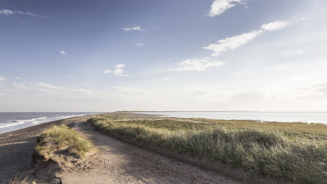
Spurn Point lies at the end of a 5 km long curved spit consisting of sand, shingle, and glacial till, extending into the mouth of the Humber Estuary. The northern portion is the narrowest part, is periodically breached by storm surges, the last one occurring in December 2013. At highest spring tides, this 'wash-over' turns the southern portion of the spit into a tidal island.
Spurn is owned by t… (read more)
Spurn is owned by t… (read more)
Spurn north end view SW over the Spurn Neck
A visit to Spurn Point 26
Looking south-west from the landward end of Spurn, over the narrow Spurn Neck (the high spring tide wash-over zone). Spurn Point itself, and the two lighthouses, are visible on the skyline towards the right.
Spurn east beach bank, swales and ripples 2
A visit to Spurn Point 25
Sand and gravel bars (possibly with a foundation of the Wolstonian age Basement Till) parallel to the coast allow the formation of elongate tidal pools, which become completely flooded by the incoming tide.
In this view the darker clayey gravel bar is in the middle distance on the left. In the foreground are large, metre-scale linguoid ripples: 'swales'. These are highly asymmetrical, with the steep lee sides facing south, indicating a predominant current direction from north to south (left to right). This is consistent with the southward longshore drift along the east of England coast
The linguoid swales in turn display centimetre-scale sand ripples on the stoss slopes. The ripples tend to be more symmetrical, indicating a current direction alternating between northward (to the left) flow on the flooding tide and southward flow (to the right) when the tide is ebbing.
In this photo the incoming tide is just beginning to flood the low swale zone.
Spurn east beach bank, swales and ripples 1
A visit to Spurn Point 24
Sand and gravel bars (possibly with a foundation of the Wolstonian age Basement Till) parallel to the coast allow the formation of elongate tidal pools, which become completely flooded by the incoming tide.
In this view the darker clayey gravel bar is in the middle distance. In the foreground are large, metre-scale linguoid ripples: 'swales'. These are highly asymmetrical, with the steep lee sides facing south, indicating a predominant current direction from north to south (left to right). This is consistent with the southward longshore drift along the east of England coast
The linguoid swales in turn display centimetre-scale sand ripples on the stoss slopes. The ripples tend to be more symmetrical, indicating a current direction alternating between northward (to the left) flow on the flooding tide and southward flow (to the right) when the tide is ebbing.
Spurn Warren view E to wind farm
A visit to Spurn Point 23
A view east from Spurn Warren, with the Humber Gateway Offshore Wind Farm visible on the horizon.
Spurn lighthouses view NE
A visit to Spurn Point 22
There are two lighthouses on Spurn; the newer 'High Lighthouse', painted black and white, was built 1893-95; the older 'Low Lighthouse' is visible on the left.
The Lower Lighthouse', was built by engineer John Smeaton and completed in 1776. But by 1892, the structure was becoming cracked and unstable, and the new 'Upper Lighthouse' was constructed to replace Smeaton's light.
The black cylinder on the top of the Lower Lighthouse is a water tank, which has replaced the former lantern turret.
Spurn Lower Lighthouse
A visit to Spurn Point 21
There are two lighthouses on Spurn; this is the older, 'Lower Lighthouse', which was built by engineer John Smeaton and completed in 1776.
By 1892, the structure was becoming cracked and unstable, and the new 'Upper Lighthouse' was constructed to replace Smeaton's light.
The black cylinder on the top is a water tank, which has replaced the former lantern turret.
Spurn High Lighthouse 3
A visit to Spurn Point 20
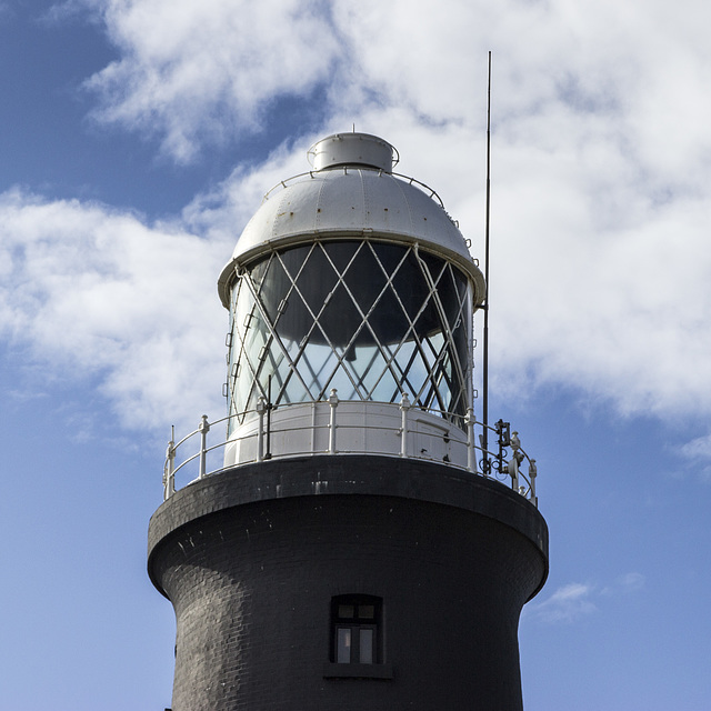
There are two lighthouses on Spurn; this is the lantern turret of the newer 'High Lighthouse', which was built 1893-95.
More details here:
historicengland.org.uk/listing/the-list/list-entry/1083476
The High Lighthouse was taken out of service in 1985 and is now managed and opened for visitors by the Yorkshire Wildlife Trust.
Spurn High Lighthouse 2
A visit to Spurn Point 19
There are two lighthouses on Spurn; this is the newer 'High Lighthouse', which was built 1893-95.
More details here:
historicengland.org.uk/listing/the-list/list-entry/1083476
The High Lighthouse was taken out of service in 1985 and is now managed and opened for visitors by the Yorkshire Wildlife Trust.
Spurn High Lighthouse 1
A visit to Spurn Point 18
There are two lighthouses on Spurn; the newer 'High Lighthouse', painted black and white, was built 1893-95; the older 'Low Lighthouse' is visible to the right of centre.
More details here:
historicengland.org.uk/listing/the-list/list-entry/1083476
The High Lighthouse was taken out of service in 1985 and is now managed and opened for visitors by the Yorkshire Wildlife Trust.
Jump to top
RSS feed- Latest items - Subscribe to the latest items added to this album
- ipernity © 2007-2026
- Help & Contact
|
Club news
|
About ipernity
|
History |
ipernity Club & Prices |
Guide of good conduct
Donate | Group guidelines | Privacy policy | Terms of use | Statutes | In memoria -
Facebook
X


