St Brides Haven: colourful rocks, colourful sea
St Brides Haven - view east
Victoria Bay and Skokholm Island
Victoria Bay bedding planes in Silurian sandstones
Gateholm and Skokholm Islands
Broad Haven (S) view east to Stackpole Head and Ca…
Church Rock from Saddle Point
Broad Haven (S) view west
Box Bay with caves
Box Bay panorama
Sandy Pit doline
Sandy Pit doline panorama
Mowingword Bay, Pinnacle Stack and Gun Cliff
Lichens and Viper's Bugloss on Mowingword Point
Stackpole Head from Mowingword Point
Barafundle Bay cloudscape from Stackpole Head
Lattice Windows sea arches and Barafundle Bay
Ladies Cave Anticline
Ladies Cave Anticline: interior hinge zone
Druidston Haven: Cliff Section 1 interpretation
Druidston Haven: Cliff Section 1 panorama
Druidston Haven: Cliff Section 2 interpretation
Druidston Haven: Cliff Section 2
Druidston Haven: Cliff Section 3 interpretation
Druidston Haven: Cliff Section 3
Druidston Haven: Cliff Section 4 interpretation
Druidston Haven: Cliff Section 4
Druidston Haven: Cliff Section 5 interpretation
Druidston Haven: Cliff Section 5
Druidston Haven: Cliff Section 6 interpretation
Druidston Haven: Cliff Section 6
Waves in Freshwater West
East Pickard Bay - English stonecrop
East Pickard Bay panorama
Gravel Bay - Moor Cliffs Formation
Freshwater West walkies
Spray haze over Freshwater West
Moody sky over Freshwater West
Conglomerate at Gravel Bay: close-up view 2
Conglomerate at Gravel Bay: close-up view 1
Conglomerates at Gravel Bay
1/60 • f/4.5 • 15.0 mm • ISO 100 •
Canon EOS 600D
EF-S15-85mm f/3.5-5.6 IS USM
Location
Lat, Lng:
You can copy the above to your favourite mapping app.
Address: unknown
You can copy the above to your favourite mapping app.
Address: unknown
See also...
See more...
Keywords
Authorizations, license
-
Visible by: Everyone -
All rights reserved
-
222 visits
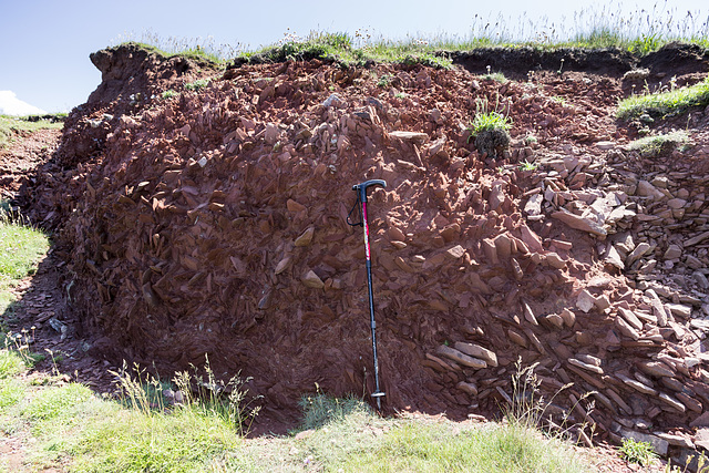
St Brides Haven solifluction deposit


Solifluction deposit ('head') on the east side of St Brides Haven, Pembrokeshire. This consists of a jumbled mass of angular sandstone fragments derived from the underlying Old Red Sandstone and was formed by freeze-thaw action at the end of the last glacial period. These deposits would have been part of the permafrost layer which partially melted during the summer months, refreezing again during the winter.
Small-scale fold-like features near the base are cryoturbation structures, probably due to ice-wedging as the refreezing permafrost layer expanded upwards.
The walking stick is about 0.9 m long.
Small-scale fold-like features near the base are cryoturbation structures, probably due to ice-wedging as the refreezing permafrost layer expanded upwards.
The walking stick is about 0.9 m long.
- Keyboard shortcuts:
Jump to top
RSS feed- Latest comments - Subscribe to the comment feeds of this photo
- ipernity © 2007-2025
- Help & Contact
|
Club news
|
About ipernity
|
History |
ipernity Club & Prices |
Guide of good conduct
Donate | Group guidelines | Privacy policy | Terms of use | Statutes | In memoria -
Facebook
X

Sign-in to write a comment.