

Cliff section east of Amroth 2
Limb Valley Autumn beeches panorama
Limb Valley Autumn trees panorama
Limb Valley Autumn trees
View south from Dunstaffnage Castle near Oban, Sco…
Ben Cruachan from Dunstaffnage Castle
Dunstaffnage Castle gatehouse top floor
Dunstaffnage Castle gatehouse middle floor
Dunstaffnage Castle Great Hall
Dunstaffnage Castle courtyard and gatehouse
Dunstaffnage Castle from south
Raasay - Inver Bay panorama
Raasay: Allt a' Bhràghad waterfall 1
Raasay: Allt a' Bhràghad waterfall 2
Raasay: Brae ruins 2
Raasay: Brae ruins 1
Raasay: Morning view over Churchton Bay to Skye
Raasay: Morning view over Churchton Bay to the Bla…
Raasay: East Suisnish pier
Raasay: East Suisnish pier slipway 1
Raasay: East Suisnish pier - W L Byers anchor 1
Raasay: East Suisnish pier - W L Byers anchor 2
Raasay: Ironstone processing works - old office bl…
West of Telpyn Point - fault in Telpyn Point Sands…
Marros west - cryogenic anticline and solifluction…
Marros west - cryogenic anticline and solifluction…
Marros west - Teague's Wood and drift-filled valle…
Telpyn-Marros panorama
Marros west cliffs
Marros Sands and Top Castle hill fort panorama
Marros Sands panorama
Marros Sands
The Settlands sand trees 3
The Settlands sand trees 2
The Settlands sand trees 1
Little Settlands - inverted thin coals and disturb…
Little Settlands - incompetent deformation 2
Little Settlands - incompetent deformation 1
Little Haven - The Settlands; detail of overturned…
Little Haven - The Settlands; detail of incompeten…
Little Haven - The Settlands; detail of incompeten…
Little Haven - The Settlands; detail of southern a…
Little Haven - The Settlands; recumbent fold, thru…
Little Haven - The Settlands; recumbent fold, thru…
Little Haven - The Settlands panorama - geological…
1/100 • f/6.3 • 27.0 mm • ISO 100 •
Canon EOS 600D
EF-S15-85mm f/3.5-5.6 IS USM
Location
Lat, Lng:
You can copy the above to your favourite mapping app.
Address: unknown
You can copy the above to your favourite mapping app.
Address: unknown
See also...
Keywords
Authorizations, license
-
Visible by: Everyone -
All rights reserved
-
309 visits
Cliff section east of Amroth 1

Telpyn Point to Amroth
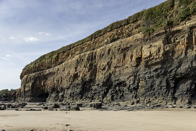
Between Amroth and Telpyn Point, magnificent cliff sections expose the upper Namurian sequence of deltaic channel-fill sandstones and intervening shale sequences.
About 1.5 km east of Amroth, this photo shows the sequence gently dipping to the west. The dark mudstones of the Gastrioceras subcrenatum Marine Band which marks the base of the Coal Measures can be seen near the top of the cliff. This is underlain by the Telpyn Point Sandstone (formerly designated as the Upper Sandstone), the uppermost main sandstone in the Namurian, and originally known as the 'Farewell Rock', so called because exploratory boreholes and shafts for coal penetrating the sandstone would no longer encounter any workable coals. Underlying the sandstone is a shale sequence, with another sandstone (pale brown-grey) visible near the base of the cliff.
See notes for details.
Between Amroth and Telpyn Point, magnificent cliff sections expose the upper Namurian sequence of deltaic channel-fill sandstones and intervening shale sequences.
About 1.5 km east of Amroth, this photo shows the sequence gently dipping to the west. The dark mudstones of the Gastrioceras subcrenatum Marine Band which marks the base of the Coal Measures can be seen near the top of the cliff. This is underlain by the Telpyn Point Sandstone (formerly designated as the Upper Sandstone), the uppermost main sandstone in the Namurian, and originally known as the 'Farewell Rock', so called because exploratory boreholes and shafts for coal penetrating the sandstone would no longer encounter any workable coals. Underlying the sandstone is a shale sequence, with another sandstone (pale brown-grey) visible near the base of the cliff.
See notes for details.
- Keyboard shortcuts:
Jump to top
RSS feed- Latest comments - Subscribe to the comment feeds of this photo
- ipernity © 2007-2026
- Help & Contact
|
Club news
|
About ipernity
|
History |
ipernity Club & Prices |
Guide of good conduct
Donate | Group guidelines | Privacy policy | Terms of use | Statutes | In memoria -
Facebook
X

Sign-in to write a comment.