

Poço da Corda (Corda Well).
Pico Viejo
Gravel Bay - Moor Cliffs Formation 1
Gravel Bay - Moor Cliffs Formation 2
Gravel Bay - millipede-like burrows in Moor Cliffs…
Gravel Bay - Moor Cliffs Formation with calcretes…
Gravel Bay - Moor Cliffs Formation with calcretes…
Gravel Bay - calcrete horizon in Moor Cliffs Forma…
East Pickard Bay panorama
Gravel Bay - Moor Cliffs Formation
Pozolana.
Canyon.
Canyon.
Canyon.
Canyon.
Canyon and mountains.
Agriculture in the canyon.
Overview to Alto Mira Valley.
Der den Fels spaltet...
Granit- und Pegmatitverwitterung
Druidston Haven: Cliff Section 6
Druidston Haven: Cliff Section 6 interpretation
Druidston Haven: Cliff Section 5
Little Settlands - incompetent deformation 1
Little Settlands - incompetent deformation 2
Little Haven - The Settlands; detail of overturned…
Little Haven - The Settlands; detail of incompeten…
Little Haven - The Settlands; detail of incompeten…
Little Haven - The Settlands; detail of southern a…
Outrage
Little Haven - The Settlands; recumbent fold, thru…
Little Haven - The Settlands; recumbent fold, thru…
Little Haven - The Settlands panorama - geological…
Little Haven - The Settlands panorama
Fox Hole Anticline - northern limb 3
Fox Hole Anticline - northern limb
Little Haven - Fox Hole Anticline
Little Haven north side geological interpretation
Little Haven north side panorama
The Settlands at Little Haven from coastal path
Calhau Volcano.
Volcanic coast.
Calhau Volcano.
Coast view.
Mount Verde (774 metres of altitude).

1/60 • f/7.1 • 15.0 mm • ISO 800 •
Canon EOS 600D
EF-S15-85mm f/3.5-5.6 IS USM
Location
Lat, Lng:
You can copy the above to your favourite mapping app.
Address: unknown
You can copy the above to your favourite mapping app.
Address: unknown
See also...
See more...
Keywords
Authorizations, license
-
Visible by: Everyone -
All rights reserved
-
263 visits
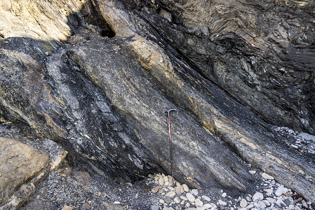
Little Settlands - inverted thin coals and disturbed bedding

Structural geology of Little Haven and The Settlands
The cliffs from Little Haven to Broad Haven (and northward) display a spectacular range of geological structures, folding, faulting and thrusting, mainly in the Lower Coal Measures. The relatively weak mudstone and shale-dominated sequences show much incompetent deformation: tight, thrusted and overturned folds, in contrast to the thicker, stronger, sandstones which have formed relatively open and concentric folds.
Immediately north of The Rain headland is a small embayment: 'Little Settlands'. Here, a chaotic looking series of disturbed bedding and downward-facing small folds are in contact with a thin coal. The whole sequence is inverted, the inversion being a continuation of the overturned structure seen on The Rain and the northern end of the main Settlands bay.
The coal is completely inverted ('up' is to down to the left). Three thin leaves of coal are visible here. Furthest to the left is the true upper leaf approx. 8 cm thick. This is underlain by pale grey seatearth (behind the walking stick), then another two thin bands of coal one by the stick handle and another beyond that. There appears to be a shear plane to the right of the stick handle; the coal leaf which uppermost in the photo may be a structural duplication repeat of the 8 cm coal leaf. See notes.
The stick is 90 cm long.
The cliffs from Little Haven to Broad Haven (and northward) display a spectacular range of geological structures, folding, faulting and thrusting, mainly in the Lower Coal Measures. The relatively weak mudstone and shale-dominated sequences show much incompetent deformation: tight, thrusted and overturned folds, in contrast to the thicker, stronger, sandstones which have formed relatively open and concentric folds.
Immediately north of The Rain headland is a small embayment: 'Little Settlands'. Here, a chaotic looking series of disturbed bedding and downward-facing small folds are in contact with a thin coal. The whole sequence is inverted, the inversion being a continuation of the overturned structure seen on The Rain and the northern end of the main Settlands bay.
The coal is completely inverted ('up' is to down to the left). Three thin leaves of coal are visible here. Furthest to the left is the true upper leaf approx. 8 cm thick. This is underlain by pale grey seatearth (behind the walking stick), then another two thin bands of coal one by the stick handle and another beyond that. There appears to be a shear plane to the right of the stick handle; the coal leaf which uppermost in the photo may be a structural duplication repeat of the 8 cm coal leaf. See notes.
The stick is 90 cm long.
- Keyboard shortcuts:
Jump to top
RSS feed- Latest comments - Subscribe to the comment feeds of this photo
- ipernity © 2007-2026
- Help & Contact
|
Club news
|
About ipernity
|
History |
ipernity Club & Prices |
Guide of good conduct
Donate | Group guidelines | Privacy policy | Terms of use | Statutes | In memoria -
Facebook
X

Sign-in to write a comment.