

Gudrun's photos

Heading for Hammerfest

Storm clouds over Barents sea
| |
|
|
|
These ominous looking clouds turned into a full storm in the Barents sea, reaching 49 kn round Nordkinn peninsula.
Click for larger size: www.ipernity.com/doc/523247/37144362/sizes/2048
EXIF: 1/80 sec. • f/8.0 • 40.0 mm • ISO 320
Canon EOS 6D, EF24-105mm f/4L IS USM

Ekstremvaeret "Ole" coming to Trondheim
| |
|
|
|
Extreme weather (force 12 with up to 20m waves out on sea) led MS Nordnorge to dock at Ila Kai instead of the regular pier. When the wind freshened up we had to leave and weathered the the storm in the fjord, going round in circles for 12 hours until the wind had calmed down a bit.
www.folkebladet.no/nyheter/article10624920.ece
The inset picture shows the scratches we got at Ila pier.

Heavenly beam
| |
|
|
|
9.35 a.m. in Toppsundet: the sun is still behind the mountains, an upper sun pillar appears over Grytøya.
www.meteoros.de/themen/halos/haloarten/ee08

Golden hour
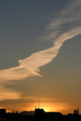
Bodø skies

Waiau Kauri grove
| |
|
|
|
8 km along 309 road a walking track leads to the most accessible and mature kauri stand on Coromandel peninsula. Kauri (agathis australis) grow very slowly and very straight, shedding their lower branches as they grow and were therefore very popular for building. There are only a few pockets of mature Kauri left, mostly in Northland and Coromandel, which are now protected.
en.wikipedia.org/wiki/Agathis_australis

Dhur Chhu
| |
|
|
|
Dhur Chhu river in Bumthang (Choekhor) valley, elevation 2650m. The valley sides are covered by pristine pinewoods.

Dochula road
| |
|
|
|
Lateral road from Wangdue Phodrang to Thimphu climbing towards Dochula pass (3100m).
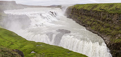
Gullfoss
| |
|
|
|
At Gullfoss the river Hvítá descends from the highlands. The river has eroded away the sedimentary layers whereas the interspersed lava flows have withstood better and form the steps over which the water falls.
Hvítágljúfur gorge
I have replaced the panorama with a new version where I have closed a few "holes" by cloning.
Made from 16 vertical shots in two rows. Canon EOS 6D, 24-105/4,0: F/8, 1/200, ISO 125

Strokkur in action
| |
|
|
|
Strokkur geyser erupts regularly every few minutes. It lies in Haukadalur geothermal area on the southern end of the Langjökull fissure swarm. The big Geysir lies dormant nearby.
The area has been experiencing repeated quake swarms and is expected to become volcanically more active with potential eruptions in Langjökull in the coming years/ decades.
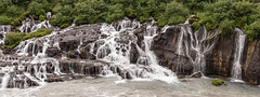
Hraunfossar
| |
|
|
|
Hraunfossar (isl.hraun=lava) are falls streaming out of porous layers of Hallmundarhraun lava field and into Hvitá river.
Hallmundarhraun covers 200 km² and was erupted around 900 A.D. from Langjökull central volcano which is in an active rift zone (western volcanic zone).

Carrito cartonero
| |
|
|
|
Scan of a photo made with a simple analogue point and shoot.
www.youtube.com/watch?v=MLGWhWBSU8I
After the crash 2001 more Porteños than before were reduced to poverty. To survive many started collecting paper in the more affluent parts of the city. Now they are organized in cooperatives, coming into the city at night, collecting all sort of reusable rubbish.
Picture in Picture!

Gracias Madres!
| |
|
|
|
The white headscarves of the Madres de Plaza de Mayo are painted on the ground where the mothers of the "Desaparecidos" have been marching weekly since 1977.

Puente Transbordador
| |
|
|
|
Puente Transbordador Nicolás Avellaneda, seen here from La Boca, spans Rio Riachuelo in Buenos Aires. Directly behind is the newer road bridge Nicolás Avellaneda, opened in 1940. The transporter bridge was opened in 1914 and stayed in operation until the 1960s. In 1999 it was declared a Monumento Histórico Nacional.
Wiki (spanish)

Acer palmatum
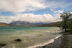
Laguna Azul
| |
|
|
|
Typical windy weather at Laguna Azul. Clouds have descended on Torres del Paine Massif, only Cerro Almirante Nieto (Paine chico) on the left can be seen.
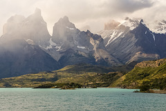
Cuernos del Paine
| |
|
|
|
Cuernos del Paine seen across Lago Pehoe. The mountains in the National Park are of granite, heavily eroded by glaciers. The Cuernos are special in that they still have a shale layer on top.
