Commorant Inn
Yelapa-Jalisco-México
Yacht Keramos Twin Foresails
Vedanta Society - San Francisco
Pigott Corner Entry Arch
Reserva Biológica Bosque Nuboso - Monteverde
Decommissioned
Before Ipernity
Tierradentro - Colombia
Masjid al-Azhar - Jakarta
Conjoined Sisters
Bikini Tree
Rainha e Suas Princesas
Morena Bahiana Tropicana
Misión San Carlos Borroméo de Carmelo
Cordillera Blanca
Mekong River Golden Triangle
Singapore - Old and New
Disfruta el Sabor
Walking on Water
Chiang Mai Teak Working Elephants
Constantine Algeria
Polo Lacrosse
Your Ship Has Sailed
Location
See also...
Keywords
Authorizations, license
-
Visible by: Everyone -
All rights reserved
-
332 visits
Mulanjescape


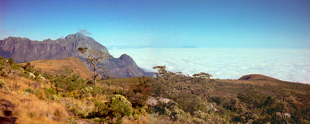
In the southern area of the Great Rift Valley on the Malawi border with Moçambique is the highest area in southern Africa. It is actual an enormous (25km diameter) granite massif with a dozen peaks, the highest reaching approximately 3,000m+. Pictured in the background is Chambe Peak 2,557 meters.
There are a series of huts where camping is allowed--all food must be packed in by foot. In the morning one can look over the tops of clouds gathered in the Great Rift Valley below. Those clouds rise into the highlands by afternoon, usually resulting in rain by early evening.
This image came from three old 35mm negatives shot from a Yashica ELECTRO 35CC camera, scanned by an HP Scanjet 5470c, merged and restored using multiple Photoshop operations.
- Keyboard shortcuts:
Jump to top
RSS feed- Latest comments - Subscribe to the comment feeds of this photo
- ipernity © 2007-2024
- Help & Contact
|
Club news
|
About ipernity
|
History |
ipernity Club & Prices |
Guide of good conduct
Donate | Group guidelines | Privacy policy | Terms of use | Statutes | In memoria -
Facebook
Twitter

Sign-in to write a comment.