

slgwv's photos
IMG_3390
| |
|
IMG_3387
| |
|
IMG_3381
| |
|
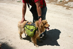
Cole and his pack

IMG_3375
| |
|
IMG_3374
| |
|
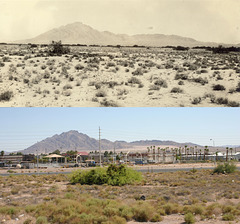
Frenchman Mountain, outside Las Vegas.
| |
|
Looking northeast. The top photo is from the Chester R. Longwell collection (#311-0071) at the University of Nevada, Las Vegas, taken ca. 1925. The bottom photo is by me, 14 June 2011. The rephoto location is on Russell Road, on the on-ramp leading up to the 515 freeway. Obviously it's thus a bit higher than the original stance, but that makes the comparison possible because we can see over all the development. The Clark Generating Station is just off the photo to the left.
Frenchman Mountain is a classic fault-block mountain that has starred in a number of geology textbook illustrations.
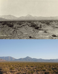
Mt. Wheeler, Spring Mountains, Nevada
| |
|
Looking south. Top photo is from the Chester R. Longwell collection (#311-0116) at the University of Nevada, Las Vegas, and was taken ca. 1925. The lower photo is by me, 10 June 2011.
Wheeler Pass is the prominent notch to the left of Mt. Wheeler, the peak in the middle. This is only a mile or so beyond Indian Springs, to the north on US-95, but here there are very few changes. The only new cultural feature is the barbed-wire fence! The exact position of the original photo is probably covered by the modern highway.
Note that this is NOT the Mt. Wheeler in Great Basin National Park, although it's named after the same explorer.
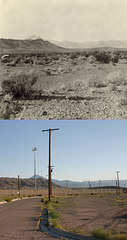
Mt. Wheeler, Spring Mountains.
| |
|
From Indian Springs looking south. Top photo is from the Chester R. Longwell collection (#311-0117) at the University of Nevada, Las Vegas, and was taken ca. 1925. The lower photo is by me, 10 June 2011.
Mt. Wheeler is the skylined peak to the left of center. There has been some development in the intervening 85 years, although this part of Indian Springs seems abandoned. Perhaps it was base housing back around WWII. There's a big air force base behind me (Creech) which is still very active--you can often see Predators flying there--and which dates back to WWII.
Note that this is NOT the Mt. Wheeler in Great Basin National Park, although it's named after the same explorer.
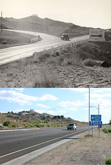
Turnoff to Boulder City, Nevada.
| |
|
Looking southwest. The top photo is from the L.F. Manis collection (#100-1113) at the University of Nevada, Las Vegas, and was taken ca. 1935. I took the lower photo on 13 June 2011.
There's been just a bit of development! I think the exact original photography stance is now under the modern highway. Note, however, that not only is the big water tank on the skyline still there, but also the building skylined on the knoll to the right (outlined). I think it was one of the government's original offices for the Boulder Canyon Project (Hoover Dam).
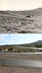
Boulder City turnoff, Nevada
| |
|
Looking west. The upper photo is from the L.F. Manis collection (#100-1112) at the University of Nevada, Las Vegas, and was taken ca. 1935; I took the lower photo on 13 June 2011. The exact original photo position is unrecoverable because of all the road construction and housing development. (I'm standing on a built-up terrace for a development behind me.) Again, the amount of development in the last 75 years is astonishing.
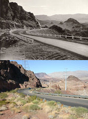
Highway to Hoover (Boulder) Dam, Nevada
| |
|
Looking northeast. The upper photo is from the L. F. Manis collection (#100-3348) at the University of Nevada, Las Vegas, and was taken in the early 1930s. The lower photo is by me, 13 June 2011.
The highway isn't all that different, but there are now lots of high-voltage transmission towers of various vintages. I think the steel frame tower on the left dates from the dam's construction, while the pylons on the right are considerably newer. The edge of the new Hoover Dam Bypass Bridge is visible at the extreme right in the modern photo (outlined).
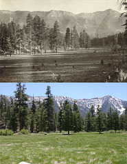
Lower Lee Meadows, Lee Canyon, Spring Mountains, N…
| |
|
Looking west toward Charleston Peak (skylined on the right). The upper photo is from the Chester R. Longwell collection (#311-0035) at the University of Nevada, Las Vegas, and was taken ca. 1925. I took the lower photo on 15 June 2011.
The most striking change is that the trees are taller! The Lee Canyon highway is also barely visible to the left of center in the modern photo (outlined). And, of course, there are no animals grazing right now, but I'm sure that you can still see them sometimes. ;)

IMG_0621
| |
|
IMG_0620
| |
|

IMG_0614
| |
|
IMG_0612
| |
|

IMG_0611
| |
|
