

slgwv's photos
IMG 5025 rot
| |
|
IMG 5024 rot adj
| |
|
IMG 5022
| |
|
IMG 5021
| |
|
IMG 5020
| |
|
IMG 5019
| |
|
IMG 5018
| |
|
IMG 5015
| |
|
IMG 5014
| |
|
IMG 5013
| |
|
IMG 5012
| |
|
IMG 5010
| |
|
IMG 5009
| |
|
IMG 5008
| |
|
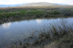
Hartson Slough close-up
| |
|
|
Note the current ripples around the weeds in the foreground. The slough is actually carrying overflow from the Susan River.
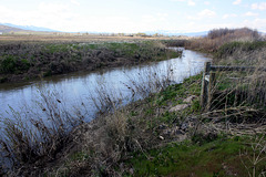
Hartson Slough
| |
|
|
|
As a follow-up to a discussion elsewhere: "slough" (locally pronounced "sloo") is widely used in the western US for a low, typically elongate shallow pond, which may even be just mud (left inset). Here the "slough" is an abandoned distributary channel of the Susan River on its way to its sump in Honey Lake. With the heavy run-off this year, the slough is actually carrying some overflow from the Susan, as can be seen by the current ripples around the weeds in the right inset.
The Susan is another landlocked river, draining eastward into the Honey Lake Basin which is within the Great Basin. It was named for Susan Roop, daughter of Isaac Roop, first territorial governor of Nevada. At that time, before any formal surveys, this area was thought to lie in Nevada.

IMG 4999
| |
|
|
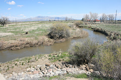
Dill Slough
| |
|
|
|
Another old distributary channel of the Susan River, carrying overflow runoff due to the heavy snowpack this season. For "slough" and the Susan River see the adjacent photo. Off US 395.
