
Little Haven - The Settlands; detail of southern a…
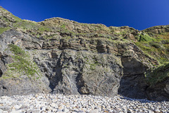
Little Haven - The Settlands; detail of incompeten…
Little Haven - The Settlands; detail of incompeten…
Little Haven - The Settlands; detail of overturned…
Little Settlands - incompetent deformation 1
Little Settlands - incompetent deformation 2
Little Settlands - inverted thin coals and disturb…
Little Haven - The Settlands; recumbent fold, thru…
Little Haven - The Settlands panorama - geological…
Little Haven - The Settlands panorama
Maer Cliff incompetent deformation
Maer Cliff incompetent deformation - detail
Folding at Monkstone Point, near Saundersfoot, Pem…
Recumbent fold near Little Haven, Pembrokeshire, w…
Thrusted Coal Measures at Ffos Las Opencast Coal S…
Thrust fault in Coal Measures at Amroth, Pembrokes…
Location
See also...
Keywords
Authorizations, license
-
Visible by: Everyone -
All rights reserved
- Photo replaced on 06 Jun 2020
-
118 visits
Little Haven - The Settlands; recumbent fold, thrusts, and overturned bedding - geological interpretation


Structural geology of Little Haven and The Settlands
The cliffs from Little Haven to Broad Haven (and northward) display a spectacular range of geological structures, folding, faulting and thrusting, mainly in the Lower Coal Measures. The relatively weak mudstone and shale-dominated sequences show much incompetent deformation: tight, thrusted and overturned folds, in contrast to the thicker, stronger, sandstones which have formed relatively open and concentric folds.
The cliffs at the east end of The Settlands bay display a series of complexly thrusted, folded and faulted Lower Coal Measures rocks. The folds are overturned to the north, becoming nearly recumbent (low-angle fold axes) near the northern headland, known as 'The Rain', seen here on the left. The complexity of the folding is mostly due to the predominance of weak mudstones and shales which undergo incompetent deformation, in contrast to the open folding in the strong sandstone Fox Hole anticline in previous photos, and in the less disturbed but overturned sandstone sequence on the left of this photo.
The principal structure in the central region of the photo is a nearly recumbent fold with several associated thrusts. There are two main thrusts and several smaller thrust splays which result in repetition of the strata, mainly around the horizon of the Amman Marine Band. Yellow arrows indicate the 'way up', younging direction, of the beds.
Interpretation linework carried out using Affinity Designer software.
More detailed view here:
This is a generalised geological interpretation of the previous photo here: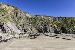
Fred Fouarge, Andy Rodker have particularly liked this photo
- Keyboard shortcuts:
Jump to top
RSS feed- Latest comments - Subscribe to the comment feeds of this photo
- ipernity © 2007-2024
- Help & Contact
|
Club news
|
About ipernity
|
History |
ipernity Club & Prices |
Guide of good conduct
Donate | Group guidelines | Privacy policy | Terms of use | Statutes | In memoria -
Facebook
Twitter
Sign-in to write a comment.