Rickets Head Black Cliff Colliery tip and Newgale
Newgale Sands 1
Newgale Sands 2
Trefrane Cliff Colliery chimney 1
Trefrane Cliff Colliery chimney 2
Trefrane Cliff Colliery chimney 3
Trefrane Cliff Colliery chimney 4
Small Copper at Trefrane Cliff Colliery
Newgale Sands 3
The Settlands at Little Haven from coastal path
Little Haven view north over Rooks Bay and The Set…
Little Haven north side panorama
Little Haven north side geological interpretation
Little Haven - Fox Hole Anticline
Fox Hole Anticline - northern limb
Fox Hole Anticline - northern limb 2
Fox Hole Anticline - northern limb 3
Fox Hole Anticline - northern limb jointing with c…
Fox Hole Anticline - northern limb with mine adit
Little Haven - The Settlands panorama
Little Haven - The Settlands panorama - geological…
Little Haven - The Settlands; recumbent fold, thru…
Little Haven - The Settlands; recumbent fold, thru…
Rickets Head end-on view
Rickets Head north mining activity panorama
Nolton Haven seaward view
Nolton Haven channel lag deposit in beach boulder…
Nolton Haven channel lag deposit in beach boulder…
Nolton Haven channel sandstones 3
Nolton Haven channel sandstones 2
Nolton Haven channel sandstones
Nolton Haven sandstone channel scours
Nolton Haven ironstone pebbles in channel lag depo…
Nolton Haven ironstone pebbles in channel lag depo…
Nolton Haven sandstone channel edge lag deposits 2
Nolton Haven sandstone channel edge lag deposits 1
Nolton Haven sandstone channel edge 2
Nolton Haven sandstone channel edge 1
Nolton Haven north west cliffs of Pennant Sandston…
Tenby Church and seafront buildings from Castle Hi…
Tenby North Sands skyscape from Castle Hill 2
Tenby North Sands skyscape from Castle Hill 1
Tenby North Sands with Inshore Rescue Boat station
Tenby from North Sands
Tenby skyscape
1/125 • f/6.3 • 15.0 mm • ISO 200 •
Canon EOS 600D
EF-S15-85mm f/3.5-5.6 IS USM
Location
See also...
See more...Keywords
Authorizations, license
-
Visible by: Everyone -
All rights reserved
-
152 visits
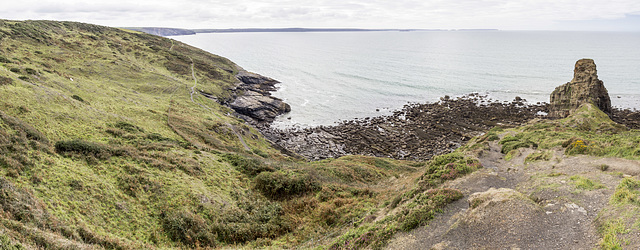
Rickets Head south mining activity panorama


Nolton Haven to Newgale
The small Nolton-Newgale coalfield is separated by faulting from the main Pembrokeshire coalfield. It lies mostly within Pennant Sandstone Formation of the Upper Coal Measures rocks.
This southward panoramic view from the coast path shows Rickets Head on the right and St Brides Bay in the background. The present-day profile of the headland is a result of former coal mining activity and the removal of overburden to access the Rickets Head Vein coal which cropped out at the base of the sandstone which comprises the up-standing pillar of rock.
The coast path climbs up from Rickets Head over the disturbed ground and spoil heaps visible in the foreground.
On the left of the photo in the flatter grassy area, are old shafts and degraded, grassed-over, spoil heaps of Rickets Head Colliery which worked the underlying Black Cliff Vein.
Stratigraphically, the rocks of Rickets Head are the highest (youngest) in the Carboniferous sequence of the Pembrokeshire coalfields.
- Keyboard shortcuts:
Jump to top
RSS feed- Latest comments - Subscribe to the comment feeds of this photo
- ipernity © 2007-2024
- Help & Contact
|
Club news
|
About ipernity
|
History |
ipernity Club & Prices |
Guide of good conduct
Donate | Group guidelines | Privacy policy | Terms of use | Statutes | In memoria -
Facebook
Twitter

Sign-in to write a comment.