Gathering Hill from the Snake Pass summit, Derbysh…
Win Hill and Parkin Clough
Over Dale, Peak District National Park
Methane vent pipe near Arkwright Town, Derbyshire
Dirtlow Rake openworks, near Castleton, Derbyshire
Moorland stripes above Glossop
Clock Tower Business Centre, Hollingwood
Pleasley colliery
Pleasley Colliery - southern aspect.
Pleasley North Shaft headframe
Pleasley North Shaft: north aspect
Pleasley Colliery South Shaft
Pleasley Colliery North Shaft headframe
Pleasley Colliery No.2 shaft winding engine
Pleasley Colliery No.1 winding engine
Pleasley Colliery No.1 winding engine drum
Pleasley Colliery No.2 South Shaft interior view
Pleasley Colliery No.2 South Shaft interior 2
Pleasley Colliery No.2 South Shaft top area
Capels and detaching hook
Pleasley Colliery No. 2 South Shaft signals
Safety reminder board at Pleasley Colliery
Recovered Westthorpe Colliery winding engine compo…
Westthorpe Colliery winding engine drum
Higger Tor from Burbage Edge
Carl Wark from Burbage Edge
Carl Wark and Higger Tor panorama
Carl Wark and Higger Tor panorama; x2 vertical exa…
Higger Tor from Burbage Edge 2
Carl Wark and Higger Tor from Burbage Edge
Carl Wark and Higger Tor from Burbage Edge; x2 ver…
Carl Wark and Sir William Hill
Stanage Edge south end from Burbage Edge
Stanage Edge south end from Burbage Edge; x2 verti…
Burbage Valley from Higger Tor
Burbage Valley from Higger Tor; x2 vertical exagge…
Burbage Valley SSE from Higger Tor
Hope Valley from Higger Tor 1
Hope Valley from Higger Tor 2
Hope Valley from Higger Tor 2; x2 vertical exagger…
Kinderscout plateau from Higger Tor, x2 vertical e…
Callow Bank and Hope Valley skyscape
Kinderscout plateau from Higger Tor
Lone Tree at Beeley Brook top
Beeley Brook top
Sunlit Chatsworth fields
Beeley Hilltop fields
Rain over Millstone Edge and the Derwent valley
Upper Lathkill Dale near Monyash, Derbyshire
Odin Sough outfall, Castleton, Derbyshire
Odin Sough tail
Crook Hill SE top from NW top
Crook Hill NW top
Crook Hill summits and wall
Chavery Coal and roof measures, Duckmanton Railway…
Duckmanton Railway Cutting SSSI
Duckmanton Railway Cutting SSSI (2)
Chavery Coal and roof strata, Duckmanton Railway C…
Amber Valley, Ashover, Derbyshire
Hyaloclastite: Upper Miller's Dale Lava front at L…
River Wye, Miller's Dale, Derbyshire
English Nature information board, Litton Mill Rail…
Grouse drinking basin 22, Stanage Edge, Yorkshire
Drinking basin 32 near Stanage End
Drinking basin 8 near High Neb on Stanage Edge
Drinking basin 14 on Stanage Edge
Drinking basin 24 near Stanage End
Stanage End Slab
Stanage End view to Moscar
Bamford Moor from High Neb
Hathersage and the Derwent valley
Stanage from High Neb
Bamford Moor and Win Hill
Crow Chin gulley and Jarvis Clough
Stanage Edge and Cattis Side Moor
Crook Hill
Ladybower and Ashop valley from Crook Hill
Far Deep Clough from Crook Hill
Crook Hill view NW from SE top
Ladybower from Crook Hill
Crook Hill view NW
Track to Bole Hill Quarries, near Hathersage.
Thorpe Cloud summit view (just!)
Abandoned pulp stones 1
Abandoned pulp stones 2
White (Edge) Christmas
Abandoned pulp stones 3
Snowy Callow Bank
The Old Snow Ent
Callow Bank and Higger Tor
Curbar Edge panoramic
Snow White Edge
Snow sheep and Ladywash
Snow Sheep
Millstone Edge panoramic
Snow textures on Sir William Hill
Millstone Edge panoramic, x2 vertical exaggeration
Millstone Edge quasi sepia
Millstone Edge snowy zoom
Padley Incline in snow
Wintry Padley
Millstone Edge in high summer
English winter landscape
Green's Mill loading point, near North Lees Hall,…
Evening grindstones
Stanage sunset
Section of the old A625 road on the Mam Tor landsl…
Mam Tor landslip, Derbyshire
Mam Tor landslip - old A625 road
Mam Tor landslip - old A625 road
1/250 • f/6.3 • 17.0 mm • ISO 100 •
Canon EOS 350D DIGITAL
Location
See also...
Keywords
Authorizations, license
-
Visible by: Everyone -
All rights reserved
-
321 visits
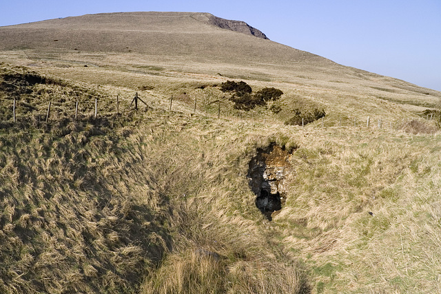
Sink Hole at the base of Mam Tor, Derbyshire


Originally uploaded for the Guesswhere UK group.
Along the western flank of Mam Tor and Rushup Edge are a series of sink holes where surface waters and streams flowing off the relatively low-permeability Mam Tor Beds and Edale Shales encounter the underlying Carboniferous Limestone. This one is near the old Windy Knoll Quarry. The water disappears underground and flows through an extensive network of cave passages before emerging at Peak Cavern and Russet Well in Castleton.
Along the western flank of Mam Tor and Rushup Edge are a series of sink holes where surface waters and streams flowing off the relatively low-permeability Mam Tor Beds and Edale Shales encounter the underlying Carboniferous Limestone. This one is near the old Windy Knoll Quarry. The water disappears underground and flows through an extensive network of cave passages before emerging at Peak Cavern and Russet Well in Castleton.
- Keyboard shortcuts:
Jump to top
RSS feed- Latest comments - Subscribe to the comment feeds of this photo
- ipernity © 2007-2024
- Help & Contact
|
Club news
|
About ipernity
|
History |
ipernity Club & Prices |
Guide of good conduct
Donate | Group guidelines | Privacy policy | Terms of use | Statutes | In memoria -
Facebook
Twitter

Sign-in to write a comment.