Location
See also...
See more...Keywords
Authorizations, license
-
Visible by: Everyone -
All rights reserved
-
1 993 visits
Sewerby cliff interpretation


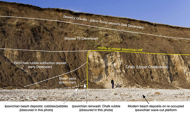
This is an interpretation of the 'buried' former Ipswichian interglacial cliff line at Sewerby, near Bridlington, East Yorkshire.
If you wish to use this photo, please ask me first.
The Ipswichian warm interglacial period occurred about 128 - 115 thousand years ago, and was followed by the Devensian glacial period which finally ended only 11,500 years ago.
The modern cliff line cuts the Ipswichian cliff ((yellow line) at an oblique angle and exposes an interglacial beach deposit overlain by rainwash (both currently obscured by mudlow). This is overlain by windblown sand and this in turn overlain by a chalk/flint solifluction deposit which marked the return of cold permafrost conditions.
The Skipsea Till is next - representing the debris 'bulldozed' and transported by the Devensian glacier, followed by the Sewerby Gravels deposited in an extensive area of melt-water channels when the glaciers eventually melted.
During the Ipswichian warm period, relative sea-levels were as high or slightly higher than the present day. The shoreline at this time extended from Sewerby to Hessle, following the foot of the Chalk Wolds, so all of present-day Holderness was under the sea. If all the glacial deposits were removed, Holderness would once again be inundated. The present-day cliff erosion is attempting to do just that!
- Keyboard shortcuts:
Jump to top
RSS feed- Latest comments - Subscribe to the comment feeds of this photo
- ipernity © 2007-2024
- Help & Contact
|
Club news
|
About ipernity
|
History |
ipernity Club & Prices |
Guide of good conduct
Donate | Group guidelines | Privacy policy | Terms of use | Statutes | In memoria -
Facebook
Twitter

Sign-in to write a comment.