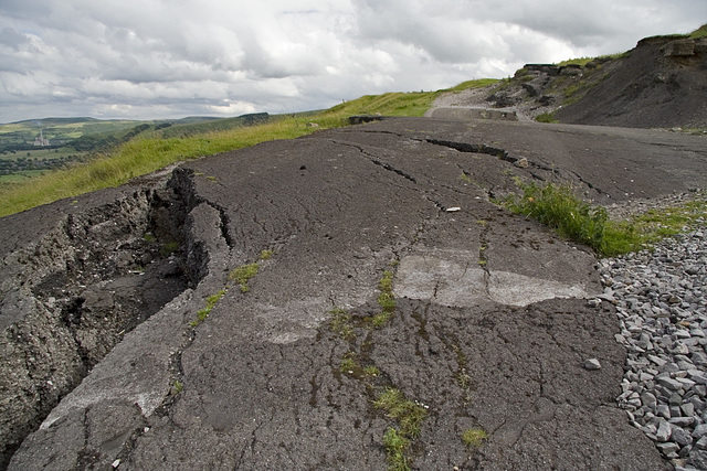
Mam Tor landslip - old A625 road
Mam Tor landslip, Derbyshire
Section of the old A625 road on the Mam Tor landsl…
Stanage sunset
Evening grindstones
Green's Mill loading point, near North Lees Hall,…
English winter landscape
Millstone Edge in high summer
Wintry Padley
Padley Incline in snow
Millstone Edge snowy zoom
Millstone Edge quasi sepia
Millstone Edge panoramic, x2 vertical exaggeration
Snow textures on Sir William Hill
Millstone Edge panoramic
Snow Sheep
Snow sheep and Ladywash
Snow White Edge
Curbar Edge panoramic
Callow Bank and Higger Tor
The Old Snow Ent
Snowy Callow Bank
Abandoned pulp stones 3
White (Edge) Christmas
Abandoned pulp stones 2
Abandoned pulp stones 1
Thorpe Cloud summit view (just!)
Track to Bole Hill Quarries, near Hathersage.
Crook Hill view NW
Ladybower from Crook Hill
Crook Hill view NW from SE top
Far Deep Clough from Crook Hill
Ladybower and Ashop valley from Crook Hill
Crook Hill
Stanage Edge and Cattis Side Moor
Crow Chin gulley and Jarvis Clough
Bamford Moor and Win Hill
Stanage from High Neb
Hathersage and the Derwent valley
Bamford Moor from High Neb
Stanage End view to Moscar
Stanage End Slab
Drinking basin 24 near Stanage End
Drinking basin 14 on Stanage Edge
Drinking basin 8 near High Neb on Stanage Edge
Drinking basin 32 near Stanage End
Grouse drinking basin 22, Stanage Edge, Yorkshire
English Nature information board, Litton Mill Rail…
River Wye, Miller's Dale, Derbyshire
Hyaloclastite: Upper Miller's Dale Lava front at L…
Amber Valley, Ashover, Derbyshire
Chavery Coal and roof strata, Duckmanton Railway C…
Duckmanton Railway Cutting SSSI (2)
Duckmanton Railway Cutting SSSI
Chavery Coal and roof measures, Duckmanton Railway…
Crook Hill summits and wall
Crook Hill NW top
Crook Hill SE top from NW top
Odin Sough tail
Odin Sough outfall, Castleton, Derbyshire
Upper Lathkill Dale near Monyash, Derbyshire
Sink Hole at the base of Mam Tor, Derbyshire
Gathering Hill from the Snake Pass summit, Derbysh…
Landslip and Cement Works
Rushup Edge and Lord's Seat from Mam Tor
Back Tor
Edale illuminations
Lose Hill Ridge from Mam Tor
Lose Hill Ridge from Mam Tor
Mam Tor face
Hope Valley from Mam Tor
Rushup Edge and Lord's Seat from Mam Tor
Lighting up the Seat of the Lord
South from Mam Tor
Winnats from Mam Tor
Odin Gorge at Odin Mine, near Castleton, Derbyshir…
Watchers on Froggatt
Columnar jointed sill at Calton Hill quarry, Derby…
White Edge 1
Erosion surface
Guidepost 1
Guidepost 2
White Edge 2
Alternative White Edge 2
White Edge 3
Alternative White Edge 4
Afternoon larches 2
White Edge grasses 2
Curbar Edge
Froggatt Edge cross bedding
Afternoon larches 1
Froggatt Edge tors 2
Froggatt Edge tors 1
Eastern Edges in the spotlight
Hay Wood birches
Hay Wood quarry cross bedding
Hay Wood evening sentinels
Hay Wood quarries
Sunlit fields of Leam
Cocking Tor panorama 2
Stone Edge chimney
Sun on Sir William
Stone fence
Cocking Tor, Ashover
Stone Edge chimney, near Ashover
Amber skyscape
Ashover from the north east escarpment
Stone Edge information plate
Stone Edge reservoir
Stone Edge reservoir and chimney
Bolehill Quarries Incline and former buildings pla…
Bungalows at Padley Chapel, Grindleford; formerly…
Gunpowder magazine, Padley Gorge, Derbyshire.
Derwent valley skyscape
Tumbling Hill evening
Grindleford skyscape
Gunpowder magazine interior, Padley Gorge, Derbysh…
Stepped topography at Shatton and Abney Moor
Mother Cap: Moor and Sky
Balancing boulder and Hargreave's Original Route
Stanage south end 3
Stanage south end 4
Padley Gorge autumnal glory
Stanage south end 1
Swine Sty and Big Moor
1/50 • f/8.0 • 17.0 mm • ISO 100 •
Location
See also...
Keywords
Authorizations, license
-
Visible by: Everyone -
All rights reserved
-
120 visits
Mam Tor landslip - old A625 road


This is a section of the old A625 Sheffield to Chapel-en-le-Frith road at the foot of Mam Tor in the Peak District. The road was built across an extensive active landslip area and was in constant need of repair. It was finally closed in 1979.
The landslip first formed about 3000 years BP, on an oversteepened slope left after Devensian. There is an 80 m high back scar in formed in the Mam Tor Beds.
The the toe of the landslip is still active today, moving at up to 2 metres per year in places.
The landslip first formed about 3000 years BP, on an oversteepened slope left after Devensian. There is an 80 m high back scar in formed in the Mam Tor Beds.
The the toe of the landslip is still active today, moving at up to 2 metres per year in places.
- Keyboard shortcuts:
Jump to top
RSS feed- Latest comments - Subscribe to the comment feeds of this photo
- ipernity © 2007-2024
- Help & Contact
|
Club news
|
About ipernity
|
History |
ipernity Club & Prices |
Guide of good conduct
Donate | Group guidelines | Privacy policy | Terms of use | Statutes | In memoria -
Facebook
Twitter

Sign-in to write a comment.