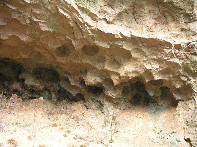
Dirtlow Rake quarry; cave system in cross section
Dirtlow Rake quarry; cave system in cross section…
Dirtlow Rake exposed vein with slickensides
Henrhyd waterfall, Coelbren, upper Swansea valley,…
View from Ard Crags, Lake District, Cumbria
As torrents in summer... 5
As torrents in summer... 4
As torrents in summer... 3
As torrents in summer... 2
As torrents in summer... 1
Approaching storm 1
Approaching storm 2
Brooding barley
Porter Waterfall 1
Porter Waterfall 2
Forge Dam weir
River Porter waterfall post-floods 1
River Porter waterfall post-floods 2
River Porter waterfall post-floods 3
River Porter waterfall post-floods 4
After the rain, the sun....
Saturday Group
Essex sunset
Dirtlow Rake quarry; vein cavity in cross section
Recumbent fold near Little Haven, Pembrokeshire, w…
Cave system exposed by Dirtlow Rake quarry near Ca…
Rain on the rose leaves
After the rain, the sun....
Rooted in stone
Porter waterfall HDR
Porter waterfall
Ox Stones again
Mayfield meadow
Field Horsetail 1
Field Horsetail 2
Gateway to Heaven - late spring
Brown Edge quarries
Different point of view
Sheffield, viewed from Fulwood Lane, Ringinglow
The Ox Stones on Burbage Moor, South Yorkshire.
Interesting footpath - Jack's Rake on Pavey Ark, L…
Walton Hall Marshes, Essex.
Thrusted Coal Measures at Ffos Las Opencast Coal S…
Bridge over the Burbage Brook, near Carl Wark, Sou…
Stitchwort 2
1/40 • f/1.8 • 7.1 mm • ISO 64 •
OLYMPUS OPTICAL CO.,LTD C5050Z
Location
See also...
Keywords
Authorizations, license
-
Visible by: Everyone -
All rights reserved
-
251 visits
Dirtlow Rake quarry; phreatic tube in cross section


This photo shows part of the modern open quarrying for fluorite and barytes along the line of Dirtlow Rake near Castleton, on the site of the former Hollandtwine Mine. This is a rather special place. On the far north-west wall, the quarrying has cut a perfect cross section through a cave system. There are vein cavities with horizontal fluting. These lead down to a meandering horizontal passage about 20 m below the original ground level. This passage must have been a phreatic tube at one time - entirely below the water table. The scalloping seen in this photo is a typical solution feature seen in these sort of tubes.
Finally, there is a lot of fine yellow-ochrous loose sediment infilling some of the swallets and partially choking up the phreatic tube. This infill can be seen in the lower part of the photo. I think this is a loess deposit - a fine wind-blown dust originating from rock 'flour' ground up by ice-age glaciers. In the last glacial period (the Devensian) the Peak District was largely free of ice, although it was under cold, permafrost conditions. Strong winds around the periphery of the ice sheets blew all the dust around which accumulated in pre-existing hollows and fissures on the formerly glaciated surface.
So, this quarry has enabled us to see karst (solution) and periglacial features that would normally only be accesible to cavers. I would hope that some of this quarry face would be preserved, but my understanding is that the whole lot will be backfilled and grassed over, so we will end up with a tidy, bland, green grassy area which tells us nothing at all. :-( But I suppose it will keep the planning authorites happy.
- Keyboard shortcuts:
Jump to top
RSS feed- Latest comments - Subscribe to the comment feeds of this photo
- ipernity © 2007-2024
- Help & Contact
|
Club news
|
About ipernity
|
History |
ipernity Club & Prices |
Guide of good conduct
Donate | Group guidelines | Privacy policy | Terms of use | Statutes | In memoria -
Facebook
Twitter

Sign-in to write a comment.